geo.wikisort.org - Island
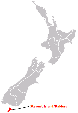
Stewart Island (Māori: Rakiura, lit. 'glowing skies', officially gazetted as Stewart Island / Rakiura) is New Zealand's third-largest island, located 30 kilometres (16 nautical miles) south of the South Island, across the Foveaux Strait. It is a roughly triangular island with a total land area of 1,746 km2 (674 sq mi). Its 164-kilometre (102 mi) coastline is deeply creased by Paterson Inlet (east), Port Pegasus (south), and Mason Bay (west). The island is generally hilly (rising to 980 metres or 3,220 feet at Mount Anglem) and densely forested. Flightless birds, including penguins, thrive because there are few introduced predators. Almost all the island is owned by the New Zealand government and over 80 per cent of the island is set aside as the Rakiura National Park.
Native name: | |
|---|---|
 | |
 | |
| Geography | |
| Location | Foveaux Strait |
| Coordinates | 47°00′S 167°50′E |
| Archipelago | New Zealand archipelago |
| Area | 1,747.74 km2 (674.81 sq mi)[1] |
| Highest elevation | 980 m (3220 ft) |
| Highest point | Mount Anglem |
| Administration | |
New Zealand | |
| Electorates | Southland (general) Te Tai Tonga (Māori) |
| MPs | Joseph Mooney (National) Rino Tirikatene (Labour) |
Local Government | |
| Regional Council | Environment Southland |
| Largest settlement | Oban |
| Territorial authority | Southland District |
| Community Board | Stewart Island/Rakiura Community Board[2] |
| Demographics | |
| Population | 440 (June 2022)[3] |
| Pop. density | 0.25/km2 (0.65/sq mi) |
Stewart Island's economy depends on fishing and summer tourism. Its permanent population was recorded at 408 people in the 2018 census,[4] most of whom live in the settlement of Oban on the eastern side of the island. Ferries connect the settlement to Bluff in the South Island. Stewart Island/Rakiura is part of the Southland District for local government purposes.
History and naming

The original Māori name, Te Punga o Te Waka a Māui, positions Stewart Island firmly at the heart of Māori mythology. Translated as "The Anchor Stone of Māui’s Canoe", it refers to the part played by the island in the legend of Māui and his crew, who from their canoe, the South Island, caught and raised the great fish, the North Island.
Rakiura is the commonly known Māori name. It is usually translated as "Glowing Skies", a reference to the aurora australis, the southern lights that are a phenomenon of southern latitudes.[5]
For some, Rakiura is the abbreviated version of Te Rakiura a Te Rakitamau, translated as "great blush of Rakitamau", in reference to the latter's embarrassment when refused the hand in marriage of not one but two daughters of an island chief.[6] According to Māori legend, a chief on the island named Te Rakitamau was married to a young woman who became terminally ill and implored him to marry her cousin after she died. Te Rakitamau paddled across Te Moana Tapokopoko a Tawhiki (Foveaux Strait) to the South Island where the cousin lived, only to discover she had recently married. He blushed with embarrassment; so the island was called Te Ura o Te Rakitamau.
Margaret Cameron-Ash claims that James Cook established the insularity of Stewart Island during his first Pacific voyage in 1770 but decided to hide his discovery for reasons of military and colonial policy.[7] However, G. A. Mawer argues that Cook was simply unsure whether it was an island because his focus was on finding the southern extent of New Zealand, and conditions were unfavourable for more closely exploring a possible strait.[8]
The strait was first charted by Owen Folger Smith, a New Yorker who had been in Sydney Harbour with Eber Bunker, from whom he probably learned of the eastern seal hunting. Smith charted the strait in the whaleboat of the sealing brig Union (out of New York) in 1804 and on his 1806 chart, it was called Smith's Straits.[9]
The island received its English name in honour of William W. Stewart. He was first officer on the Pegasus, which visited in 1809, and he charted the large south-eastern harbour that now bears the ship's name (Port Pegasus) and determined the northern points of the island, proving that it was an island.[10][11] In 1824, he initiated plans in England to establish a timber, flax and trading settlement at Stewart Island and sailed there in 1826,[10] with it becoming known as Stewart's Island.
In 1841, the island was established as one of the three Provinces of New Zealand and was named New Leinster. However, the province existed on paper only and was abolished after only five years. With the passing of the New Zealand Constitution Act 1846, the province became part of New Munster, which entirely included the South Island.[12] When New Munster was abolished in 1853, Stewart Island became part of Otago Province until 1861, when Southland Province split from Otago. In 1876, the provinces were abolished altogether.
For most of the twentieth century, "Stewart Island" was the official name, and the most commonly used. The name was officially altered to Stewart Island/Rakiura by the Ngāi Tahu Claims Settlement Act 1998, one of many such changes under the Ngāi Tahu treaty settlement.[13]
Geography


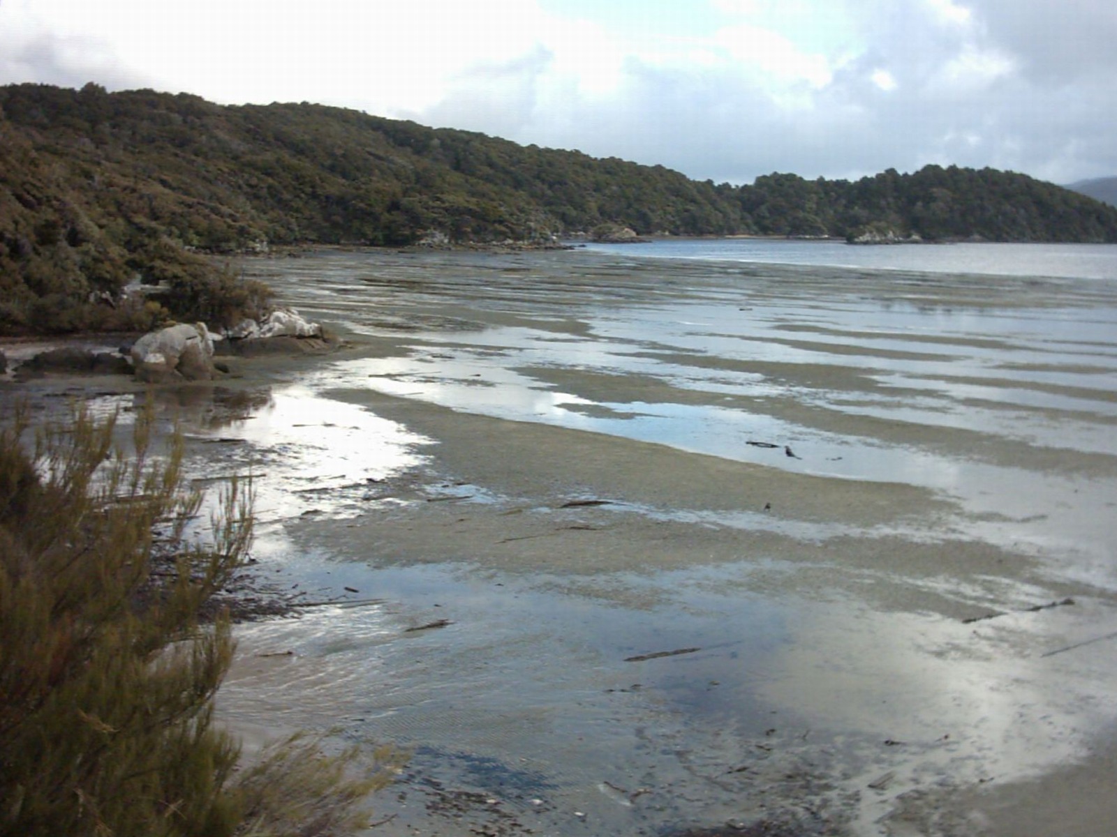
Stewart Island has an area of 1,680 square kilometres (650 sq mi).[14] Its terrain is hilly and, like most of New Zealand, Stewart Island has an Oceanic climate. The north is dominated by the swampy valley of the Freshwater River. The river rises close to the northwestern coast and flows southeastwards into the large indentation of Paterson Inlet. The highest peak is Mount Anglem (980 metres (3,220 ft)), close to the northern coast. It is one of a rim of ridges that surround Freshwater Valley.
The southern half is more uniformly undulating, rising to a ridge that runs south from the valley of the Rakeahua River, which also flows into Paterson Inlet. The southernmost point in this ridge is Mount Allen, at 750 metres (2,460 ft). Notable twin rock formations in this region are known as Gog and Magog.[15] In the southeast the land is somewhat lower, and is drained by the valleys of the Toitoi River, Lords River, and Heron River. South West Cape on this island is the southernmost point of the main islands of New Zealand.
Mason Bay, on the west side, is notable as a long sandy beach on an island where beaches are typically far more rugged. One suggestion is that the bay was formed in the aftershock of a meteorite impact in the Tasman Sea; however, no evidence has been found to support such a claim.[16][17]
Three large and many small islands lie around the coast. Notable among these are Ruapuke Island, in Foveaux Strait 32 kilometres (20 mi) northeast of Oban; Codfish Island, close to the northwest shore; and Big South Cape Island, off the southwestern tip. The Titi / Muttonbird Islands group is between Stewart Island and Ruapuke Island, around Big South Cape Island, and off the southeastern coast. Other islands of interest include Bench Island, Native Island, and Ulva Island, all close to the mouth of Paterson Inlet, and Pearl Island, Anchorage Island, and Noble Island, close to Port Pegasus in the southwest. Further offshore The Snares are oceanic islands, a volcano and some smaller islets, that were never connected to the larger Stewart Island.
Stewart Island has a temperate climate.[18] However, one travel guide mentions "frequent downpours that make 'boots and waterproof clothing mandatory",[19] and another guide says that rainfall in Oban, the principal settlement, is 1,600 to 1,800 mm (63 to 71 in) a year.[20]
Owing to an anomaly in the magnetic latitude contours, this location is well placed for observing Aurora australis.
Approximately 18,000 years ago during the Last Glacial Maximum when sea levels were over 100 metres lower than present day levels, Stewart Island / Rakiura and its surrounding islands were connected to the rest of New Zealand. Sea levels began to rise 7,000 years ago, eventually separating Stewart Island / Rakiura from the mainland.[21]
Demographics
Stewart Island covers 1,747.74 km2 (674.81 sq mi)[1] including the offshore islands, the most sizeable being Ruapuke Island, Codfish Island / Whenua Hou and Taukihepa / Big South Cape Island. It had an estimated population of 440 as of June 2022,[3] with a population density of 0.25 people per km2.
| Year | Pop. | ±% p.a. |
|---|---|---|
| 2006 | 402 | — |
| 2013 | 378 | −0.88% |
| 2018 | 408 | +1.54% |
| Source: [4] | ||
Stewart Island had a population of 408 at the 2018 New Zealand census, an increase of 30 people (7.9%) since the 2013 census, and an increase of 6 people (1.5%) since the 2006 census. There were 222 households. There were 216 males and 195 females, giving a sex ratio of 1.11 males per female. The median age was 49.3 years (compared with 37.4 years nationally), with 54 people (13.2%) aged under 15 years, 57 (14.0%) aged 15 to 29, 204 (50.0%) aged 30 to 64, and 90 (22.1%) aged 65 or older.
Ethnicities were 93.4% European/Pākehā, 19.9% Māori, 1.5% Pacific peoples, 0.7% Asian, and 2.2% other ethnicities (totals add to more than 100% since people could identify with multiple ethnicities).
The proportion of people born overseas was 16.9%, compared with 27.1% nationally.
Although some people objected to giving their religion, 67.6% had no religion, 23.5% were Christian, 0.7% were Buddhist and 2.9% had other religions.
Of those at least 15 years old, 84 (23.7%) people had a bachelor or higher degree, and 63 (17.8%) people had no formal qualifications. The median income was $33,500, compared with $31,800 nationally. 57 people (16.1%) earned over $70,000 compared to 17.2% nationally. The employment status of those at least 15 was that 207 (58.5%) people were employed full-time, 54 (15.3%) were part-time, and 3 (0.8%) were unemployed.[4]
International Dark Sky Sanctuary
In January 2019, Stewart Island/ Rakiura was accredited as a Dark Sky Sanctuary by the International Dark-Sky Association. This designation is given for sites in very remote locations to increase awareness of their dark sky characteristics and promote long term conservation. The application for accreditation was made by Venture Southland, an agency responsible for the region's economic and community development initiatives and tourism promotion, with the aim of attracting more visitors, particularly in the winter period.[22][23]
Settlements
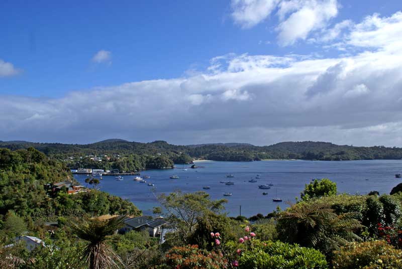
The only town is Oban, on Halfmoon Bay.
A previous settlement, Port Pegasus, once boasted several stores and a post office, and was located on the southern coast of the island. It is now uninhabited, and is accessible only by boat or by an arduous hike through the island. Another site of former settlement is at Port William, a four-hour walk around the north coast from Oban, where immigrants from the Shetland Islands settled in the early 1870s. This was unsuccessful, and the settlers left within one to two years, most for sawmilling villages elsewhere on the island.
Since 1988 the electricity supply on Stewart Island has come from diesel generators; previously residents used their own private generators. As a consequence electric power is around three times more expensive than in the South Island, at NZ$0.59/kWh in 2016.[24] After photovoltaic and wind generation were tested on the island,[24] the government Provincial Growth Fund put $3.16 million towards building wind turbines on Stewart Island.[25] The effort was defeated by local landowners who refused to grant access to the site through their property and general obstruction efforts by various parties.[26]
Economy and communications
Fishing has been, historically, the most important element of the economy of Stewart Island, and while it remains important, tourism has become the main source of income for islanders. There has also been some farming and forestry.[citation needed] Oban has mainly sealed main roads, and some gravel roads on the outskirts.
Stewart Island Flights links Ryan's Creek Aerodrome and Invercargill Airport and aircraft also land on the sand at Mason Bay, Doughboy Bay, and West Ruggedy Beach. A regular passenger ferry service runs between Bluff and Oban. The only ferry/barge link to the South Island for vehicles is to Bluff.
Stewart Island is able to receive most AM and FM radio stations broadcast in the Southland region. Television services are available via satellite using Sky or Freeview. Analogue terrestrial television services could be received on Stewart Island from the Hedgehope television transmitter located in the South Island prior to the analogue switch off on 28 April 2013.
Telecommunications
Oban has ADSL broadband and phone services delivering speeds up to 24Mbit/s download.
Spark, 2degrees and Vodafone all offer 3G cellphone coverage. Spark also offers 4G[27] 700 MHz[28] coverage.
Spark provide 4G Wireless Broadband,[29] with Vodafone providing 3G Rural Wireless Broadband.[30]
All of the above services are delivered via a radio link from Bluff.[31]
Government

From 1841 to 1853, Stewart Island was governed as New Leinster Province, then as part of New Munster Province. From 1853 onwards, it was part of the Otago Province.
In local government today, Stewart Island is represented by one councilor on the Southland District Council. There is a Stewart Island/Rakiura Community Board to serve as the link between the community and the District Council. At the Southland Regional Council, it is part of the Invercargill-Rakiura ward.
Stewart Island shares with some other islands a certain relaxation in some of the rules governing commercial activities. For example, every transport service operated solely on Great Barrier Island, the Chatham Islands, or Stewart Island is exempt from the Transport Act of 1962.
Ecology
Flora
Although the clay soil is not very fertile, the high rainfall and warm weather mean that the island is densely forested throughout. Native plants include the world's southernmost dense forest of podocarps (southern conifers) and hardwoods such as rātā and kāmahi in the lowland areas with mānuka shrubland at higher elevations. The trees are thought to have become established here since the last ice age from seeds brought across the strait by seabirds, which would explain why the beech trees that are so common in New Zealand, but whose seeds are dispersed by the wind rather than birds, are not found on Stewart Island.
Noeline Baker purchased land near Halfmoon Bay in the early 1930s and with a checklist by botanist Leonard Cockayne populated it with all the local indigenous plants. She gave the land and her house to the government in 1940, and today Moturau Moana is New Zealand's southernmost public garden.[32]
Fauna
There are many species of birds on Stewart Island that have been able to continue to thrive because of the relative absence of the cats, rats, stoats, ferrets, weasels and other predators that humans brought to the main islands. There are even more species of birds, including huge colonies of sooty shearwater and other seabirds, on The Snares and the other smaller islands offshore. The birds of Stewart Island include weka, kākā, albatross, the flightless Stewart Island kiwi, silvereyes, fantails, and kererū. The endangered yellow-eyed penguin has a significant number of breeding sites here,[33] while the large colonies of sooty shearwaters on the offshore Muttonbird Islands are subject to muttonbirding, a sustainable harvesting program managed by Rakiura Māori. Meanwhile, a small population of kakapo, a flightless parrot which is very close to extinction, was found on Stewart Island in 1977 and the birds subsequently moved to smaller islands (Codfish Island) for protection from feral cats. The South Island saddleback is similarly preserved. Stewart Island is the sole remaining breeding place of the critically endangered southern New Zealand dotterel.
The South Island giant moa (Dinornis robustus) occurred on the island, subfossil remains having been retrieved in its dunes.[34]
Threats and preservation
As the island has always been sparsely populated and there has never been very much logging, much of the original wildlife is intact, including species that have been devastated on the larger islands to the north since colonisation and industrialisation in the 19th century. However, although habitats and wildlife were not threatened by invasive species historically, now there are populations of cats, rats and brushtail possums on the island, as well as a large population of white-tailed deer, which are hunted for meat and sport, introduced to coastal areas. There is also a small population of red deer confined to the inland areas.[35] Almost all the island is owned by the New Zealand government and over 80 per cent of the island is set aside as the Rakiura National Park, New Zealand's newest national park. Many of the small offshore islands, including the Snares, are also protected.
Publicity and promotions
Residents of Stewart Island have held a number of mock promotional fundraising events regarding a declaration of independence for the island, and to have it renamed to its original name of "Rakiura".
An effort to raise NZ$6,000 for a new swimming pool at the island's school involved selling 50-cent passports for the newly "independent" island. On 31 July 1970, a mock ceremony featured a declaration of independence, and the new republic's flag was unveiled.
These efforts were not serious attempts for independence, and Stewart Island remains a part of the New Zealand state.[36]
References
- "ArcGIS Web Application". statsnz.maps.arcgis.com. Retrieved 4 February 2022.
- "Stewart Island/Rakiura Community Board". Southland District Council. Retrieved 5 February 2022.
- "Population estimate tables - NZ.Stat". Statistics New Zealand. Retrieved 25 October 2022.
- "Statistical area 1 dataset for 2018 Census". Statistics New Zealand. March 2020. Stewart Island (359300). 2018 Census place summary: Stewart Island
- Walrond, Carl (1 May 2015). "Stewart Island/Rakiura". Te Ara: The Encyclopedia of New Zealand.
- "Features: Rakiura National Park". Department of Conservation (New Zealand). Retrieved 6 May 2014.
- Cameron-Ash, M. (2018). Lying for the Admiralty. Sydney: Rosenberg. pp. 141–145. ISBN 9780648043966.; But see also G.A. Mawer, review of Lying for the Admiralty: Captain Cook's Endeavour Voyage, The Globe, No. 84, 2018, pp.59-61; Nigel Erskine, “James Cook's False Trail: Hidden Discoveries, Altered Records”, Signals, No. 125, Dec 2018 – Feb 2019 pp.72–73. Both these authors argue against Cameron-Ash's contention.
- Mawer, GA (2018). "Mawer, GA. Lying for the admiralty: Captain Cook's endeavour voyage [Book Review] [online]". The Globe. No. 84, 2018: 59–61 – via ProQuest.
- Howard, Basil, and Stewart Island Centennial Committee. Rakiura: a History of Stewart Island, New Zealand, Basil Howard Reed for the Stewart Island Centennial Committee, Dunedin, 1940, p.22; Charles A. Begg and Neil C. Begg, Port Preservation, Christchurch, Whitcombe & Tombs, 1973, p.61; Peter Entwisle, Behold the Moon: The European Occupation of the Dunedin District 1770–1848, Dunedin, Port Daniel Press, 1998.
- Foster, Bernard John (1966). "Stewart, Captain William W.". In McLintock, Alexander (ed.). An Encyclopaedia of New Zealand. Retrieved 19 May 2019 – via Te Ara – the Encyclopedia of New Zealand.
- John O'C. Ross, William Stewart, Sealing Captain, Trader and Speculator, Aranda (A.C.T), Roebuck Society, 1987, pp. 97–117.
- Paterson, Donald Edgar (1966). "New Leinster, New Munster, and New Ulster". In McLintock, Alexander (ed.). An Encyclopaedia of New Zealand. Retrieved 18 May 2019 – via Te Ara – the Encyclopedia of New Zealand.
- Schedule 96 Alteration of place names
- Walrond, Carl (3 September 2012). "Stewart Island/Rakiura – New Zealand's third main island". Te Ara: The Encyclopedia of New Zealand. Manatū Taonga Ministry for Culture and Heritage. Retrieved 16 December 2012.
- Silverwood, Neil (17 May 2017). "Roaring across the Tin Range". Wilderness Magazine. Retrieved 11 September 2021.
- Collins, Simon (6 February 2004). "Expedition hunts giant meteor". The New Zealand Herald. Retrieved 1 April 2020.
- Goff J, Dominey-Howes D, Chagué C, Courtney C (2010). "Analysis of the Mahuika comet impact tsunami hypothesis". Marine Geology. 271 (3): 292–296. Bibcode:2010MGeol.271..292G. doi:10.1016/j.margeo.2010.02.020. Retrieved 1 April 2020.
- "weather". Stewart Island. Stewart Island Promotion Association Inc. Retrieved 30 April 2021.
- "Weather in Stewart Island". When to go & weather. Lonely Planet. 2012. Archived from the original on 6 June 2014. Retrieved 16 December 2012.
- "Weather". Wilderness Experience. Raggedy Range. 2012. Retrieved 16 December 2012.
- "Estuary origins". National Institute of Water and Atmospheric Research. Retrieved 3 November 2021.
- "New night sky sanctuary tipped to shine a spotlight on Stewart Island". RNZ. 7 January 2019. Retrieved 28 April 2021.
- "Stewart Island / Rakiura (New Zealand)". International Dark-Sky Association. Retrieved 28 April 2021.
- "Stewart Is may lead NZ in green power". 26 April 2008. Archived from the original on 3 June 2010.
- "Provincial Growth Fund bankrolls two wind turbines for Stewart Island". Stuff. 22 November 2019. Retrieved 27 January 2020.
- "Staunch opposition to wind turbines keeps Stewart Island running on diesel power". Stuff. 28 May 2021. Retrieved 30 December 2021.
- "Spark NZ network coverage". www.spark.co.nz. Retrieved 1 February 2021.
- "GIS Geek". gis.geek.nz. Retrieved 1 February 2021.
- "Broadband Map". broadbandmap.nz. Retrieved 1 February 2021.
{{cite web}}: CS1 maint: url-status (link) - "Vodafone Rural Wireless Broadband service. RBI". www.vodafone.co.nz. Retrieved 1 February 2021.
- "GIS Geek". gis.geek.nz. Retrieved 1 February 2021.
- Taylor, Leah. "Isabel Noeline Baker". Dictionary of New Zealand Biography. Ministry for Culture and Heritage. Retrieved 31 December 2011.
- Hogan, C. Michael (2009). "Yellow-eyed Penguin: Megadypes antipodes". GlobalTwitcher.com. ed. N. Stromberg
- "A partial skeleton provides evidence for the former occurrence of moa populations on Rakiura Stewart Island". New Zealand Journal of Ecology. 15 November 2021.
- "Rakiura Island temperate forests". Terrestrial Ecoregions. World Wildlife Fund.
- Stewart Island (New Zealand). FOTW Flags Of The World.
Further reading
- Dempsey, Gertrude (1964). The Little World of Stewart Island (Hardback). Wellington: A.H. & A. W. Reed.
- Hall-Jones, John (1994). Stewart Island Explored (Hardback). Invercargill: Craig Printing. ISBN 0-908629-42-7.
- Sansom, Olga (2006). In the Grip of an Island: Early Stewart Island History (Hardback). Invercargill: Cadsonbury. ISBN 978-1-877346-14-9.
- Sansom, Olga (1970). The Stewart Islanders (Hardback). Wellington: A.H. & A. W. Reed. ISBN 978-0-589-00454-5.
- Sansom, Olga (1974). One Hundred Years of Schooling at Stewart Island, 1874–1974. Halfmoon Bay: Stewart Island School Centennial Committee.
External links
Authority control | |
|---|---|
| General | |
| National libraries | |
На других языках
[de] Stewart Island
Stewart Island (Māori: Rakiura), offiziell Stewart Island/Rakiura[1] genannt, ist die drittgrößte Insel Neuseelands. Sie schließt sich 30 km südlich an die Neuseeländische Südinsel an und umfasst eine Fläche von 1680 km².[2]- [en] Stewart Island
[es] Isla Stewart
La isla Stewart (Rakiura en maorí) es una isla de Nueva Zelanda, la tercera por tamaño del país. Se encuentra ubicada 30 km al sur de la isla Sur, separada de esta por el estrecho de Foveaux. Tiene 400 habitantes aproximadamente, la mayoría establecidos en la ciudad de Oban. Posee un área de 1746 km².[fr] Île Stewart (Nouvelle-Zélande)
L’île Stewart officiellement nommée Stewart Island/Rakiura, est la troisième île néo-zélandaise par sa superficie (1 746 km2), située dans la mer de Tasman à 27 km au sud de l’île du Sud. Elle en est séparée par le détroit de Foveaux. Elle compte 387 habitants, résidant dans le seul village d’Oban.[it] Isola Stewart
Stewart, conosciuta anche col nome Māori Rakiura, con i suoi 1680 km²[1] è la terza isola per estensione della Nuova Zelanda. Si trova 39 chilometri[1] più a sud rispetto all'Isola del Sud, da cui è separata dallo stretto di Foveaux. La popolazione residente è di sole 381 persone[2], la maggior parte delle quali vive nell'insediamento di Oban.[ru] Стьюарт (остров)
Стьюарт[1] (англ. Stewart Island), или Ракиура (маори Rakiura), — третий по величине остров Новой Зеландии. Лежит в 30 км к югу от Южного острова и отделён от него проливом Фово. К юго-западу от Стюарта находится архипелаг Снэрс.Другой контент может иметь иную лицензию. Перед использованием материалов сайта WikiSort.org внимательно изучите правила лицензирования конкретных элементов наполнения сайта.
WikiSort.org - проект по пересортировке и дополнению контента Википедии