geo.wikisort.org - Island
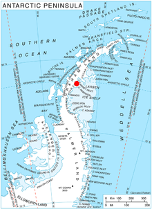
Stanley Island (66°32′S 63°40′W) is a 3.2 km (2 mi) long and 520 m high island off Heros Peninsula on Foyn Coast, Antarctica. It lies in the western part of Cabinet Inlet, 8 km (5 mi) northeast of Spur Point and 6 km (4 mi) east of Balabanski Crag.
The island was charted by the FIDS in 1947 and named for Rt. Hon. Oliver F.G. Stanley, M.P., Secretary of State for the British Colonies, who played an important part in establishing the survey. This island was photographed from the air during 1947 by the Ronne Antarctic Research Expedition under Finn Ronne.
References
- Stanley Island. SCAR Composite Antarctic Gazetteer
This Foyn Coast location article is a stub. You can help Wikipedia by expanding it. |
На других языках
[de] Stanley Island
Stanley Island ist eine 3 km lange und bis zu 520 m hohe Insel vor der Foyn-Küste des Grahamlands im Norden der Antarktischen Halbinsel. Sie liegt 6 km nordöstlich des Spur Point im westlichen Teil des Cabinet Inlet.- [en] Stanley Island (Antarctica)
Текст в блоке "Читать" взят с сайта "Википедия" и доступен по лицензии Creative Commons Attribution-ShareAlike; в отдельных случаях могут действовать дополнительные условия.
Другой контент может иметь иную лицензию. Перед использованием материалов сайта WikiSort.org внимательно изучите правила лицензирования конкретных элементов наполнения сайта.
Другой контент может иметь иную лицензию. Перед использованием материалов сайта WikiSort.org внимательно изучите правила лицензирования конкретных элементов наполнения сайта.
2019-2025
WikiSort.org - проект по пересортировке и дополнению контента Википедии
WikiSort.org - проект по пересортировке и дополнению контента Википедии