geo.wikisort.org - Island
Sonsorol is one of the sixteen states of Palau. The inhabitants speak Sonsorolese, a local Chuukic language, and Palauan.
Sonsorol | |
|---|---|
State | |
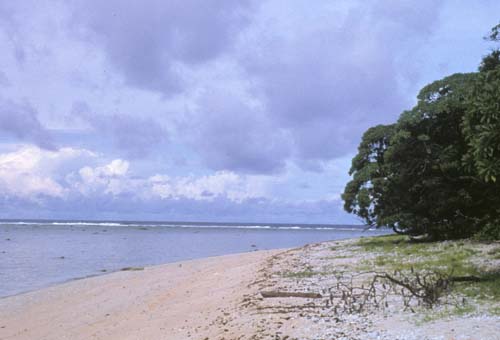
 Merir Island, Sonsorol State | |
 Flag | |
 Location of Sonsorol in Palau | |
| Country | |
| Capital | Dongosaru |
| Area | |
| • Total | 3.12 km2 (1.20 sq mi) |
| • Land | 3.12 km2 (1.20 sq mi) |
| • Water | 0 km2 (0 sq mi) |
| Population (2015 Census) | |
| • Total | 40 |
| • Density | 13/km2 (33/sq mi) |
| • Official languages | Palauan English Sonsorolese |
| ISO 3166 code | PW-370 |
The islands of the state of Sonsorol, together with the islands of Hatohobei, form the Southwest Islands of Palau.
History
The first sighting by Europeans of the Sonsorols, was that of Sonsorol and Fanna by the Spanish ship Trinidad then commanded by Gonzalo Gómez de Espinosa on 6 May 1522.[1][2] These two were collectively charted as San Juan islands (St.John) as they were sighted on the day of its festivity. A Spanish missionary expedition commanded by Sargento Mayor Francisco Padilla arrived to Sonsorol on 30 November 1710, coming from Manila on board of patache Santísima Trinidad. In 1712 they were explored by an expedition commanded by Spanish naval officer Bernardo de Egoy.[3]
In 1899 Spain decided to sell the islands to Germany, which lost control over the territory in World War I, when Japan took over. The United States took possession of the area at the end of the World War II until Palau's independence.
During December 2012, the state suffered severely from Typhoon Bopha and people were evacuated to Akebesang in Koror. There were 37 people from Sonsorol, 19 from Pulo Anna and 2 from Merir. A couple of months later, and due to government decision, only Sonsorol was re-inhabited (cheaper and closer to get to and send supplies). 42 people have returned to the island, and it is the only inhabited island in the state (as of 2014).
Geography
The administrative center, and only village, is Dongosaru on Sonsorol island. The state has a total area of 312 hectares distributed among several islands.
Islands
The state is subdivided into four municipalities, which correspond to the four individual islands, that were previously inhabited. The islands are, from north to south (Fanna Island and Sonsorol Island are together called Sonsorol Islands):
| No. | Municipality (Island) | Village (or Former) | Area (km²) | Population census 2015 | Coordinates |
|---|---|---|---|---|---|
| 1 | Fanna | - | 0.48 | 0 | 05°21′09″N 132°13′32″E |
| 2 | Sonsorol | Dongosaru | 1.31 | 40 | 05°19′28″N 132°13′16″E |
| 3 | Pulo Anna | 0.42 | 0 | 04°39′34″N 131°57′49″E | |
| 4 | Merir | 0.91 | 0 | 04°19′27″N 132°18′37″E | |
| State of Sonsorol | Dongosaru | 3.12 | 40 |
Fanna
Fanna, also called Fana, is encircled by a coral reef extending 160 to 480 m offshore, and nearly circular in shape, with a diameter of 350 m. The island is thickly wooded with coconut palms and other trees. The island is referenced as a municipality. Mariano Carlos was serving as chief from 2000 until the Typhoon Bopha evacuation. Fanna Island and nearby Sonsorol Island 1.6 km further south together form the Sonsorol Islands.
Sonsorol
Sonsorol Island, also called Dongosaro or Dongosaru, is encircled by a coral reef extending 160 to 480 m offshore. It is 2 km long north south, and up to 890 m wide in the north. It is located 1.6 km south of Fanna Island. The village of Dongosaro, which is the capital of the state, is located on the west coast. The island is thickly wooded with coconut palms and other trees. Together with Fanna, it forms the Sonsorol Islands.
Sonsorol was probably the first of Palau islands visited by a European - the Jesuit expedition of Francisco Padilla on 30 November 1710. A year after Typhoon Bopha, Palau government issued a reconstruction plan to this island, and also built a small dock.
Pulo Anna


Pulo Anna or Puro is fringed by a coral reef extending beyond 460 m offshore. The island itself is about elliptical and measures 800 meters northeast-southwest, and is up to 550 meters wide. A village named Puro was once on the northwest side of the island. Pulo Anna lies in the flow of the Equatorial Countercurrent throughout the year.
Merir
Merir Island, or Melieli, is fringed by reef which extends beyond 1100 m offshore in the south and 160 m in the north. The edges of the reef are steep-to, except at the northern end where a spit, with a depth of 12.8 meters at its outer end, extends about 1300 meters northward. The island itself is 2.200 meters north south, and up to 600 meters wide. A village named Melieli, which had a radio station, was located on the northwest side of the island.
Demography
The population of the state was 40 in the 2015 census and median age was 30.0 years.[4] The official languages of the state are Palauan, English and Sonsorolese.[5] Nurap is the title of the traditional high chief from the state.[6]
Political system
The state of Sonsorol, with population of less than 50, has an elected chief executive, governor. The state also has a legislature elected every four years.[7] The state population elects one of the members of the House of Delegates of Palau.

Education
The Ministry of Education operates two public schools in the state:
- Pulo Anna Elementary School - Built in 1972, it has one classroom and one teacher, with facilities for its students (five, as of September 2018) to stay on the otherwise deserted island[8]
- Sonsorol Elementary School - Established in 1972, it has one classroom and one teacher, to serve the students (thirteen, as of September 2018) who already live on the island[9]
In 1962, the country opened its only public high school, Palau High School in Koror City, which is 300 kilometres (190 mi) across the water from Sonsorol; children from Sonsorol state make arrangements to live in Koror City if they choose to continue their grade school education.[10]
References
- Brand, Donald D. The Pacific Basin: A History of its Geographical Explorations The American Geographical Society, New York, 1967, p.119.
- Sharp, Andrew The discovery of the Pacific Islands Oxford, 1960, p.10.
- Coello, Francisco "Conflicto hispano-alemán" Boletín de Sociedad Geográfica de Madrid, t.XIX. 2º semestre 1885, Madrid, p.247
- "2015 Census of Population, Housing and Agriculture for the Republic of Palau" (PDF). Palau Government. Office of Planning and Statistics.
- Leonard, Thomas M. (2006). Encyclopedia of the Developing World. Taylor & Francis. ISBN 9780415976640.
- "Council of Chiefs – PalauGov.pw".
- "State/National Election Schedule". Palau Election Commission. 5 November 2020.
- "Pulo Anna Elementary School". Ministry of Education, Republic of Palau. Koror City. 2018-09-21. Archived from the original on 2018-12-09. Retrieved 2020-03-29.
- "Sonsorol Elementary School". Ministry of Education, Republic of Palau. Koror City. 2018-09-21. Archived from the original on 2018-12-09. Retrieved 2020-03-29.
- "Palau High School". Ministry of Education, Republic of Palau. Koror City. 2016. Archived from the original on 2018-11-24. Retrieved 2020-03-29.
External links
- Sonsorol Island
- Municipalities with Chiefs mentioned
- Satellite views
- Sailing Directions
- Atoll Research Bulletin 267
- Honorary Consulate of the Republic of Palau to the UK &NI
- Constitution of the State of Sonsorol
States of Palau | ||
|---|---|---|
Authority control | |
|---|---|
| General |
|
| National libraries | |
Другой контент может иметь иную лицензию. Перед использованием материалов сайта WikiSort.org внимательно изучите правила лицензирования конкретных элементов наполнения сайта.
WikiSort.org - проект по пересортировке и дополнению контента Википедии