geo.wikisort.org - Island
Shimoji-shima (下地島), (Miyako: Sïmuzï) is one of the Miyako Islands, a part of the Ryukyu Islands. The island is administered by Miyakojima, Okinawa Prefecture, Japan. The island is connected to Irabu Island via Nakaji Bridge (仲地橋).[1]
This article may be expanded with text translated from the corresponding article in Japanese. (January 2021) Click [show] for important translation instructions.
|
Native name: Shimoji-shima (下地島) | |
|---|---|
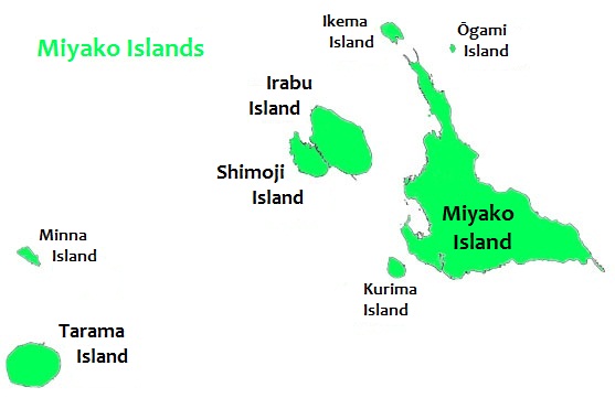 Shimoji Island is to the west of Miyako Island | |
| Geography | |
| Location | Okinawa Prefecture |
| Coordinates | 24°48′58″N 125°9′25″E |
| Archipelago | Miyako Islands |
| Area | 9.68 km2 (3.74 sq mi)[1] |
| Highest elevation | 21.6 m (70.9 ft) |
| Administration | |
Japan | |
| Prefecture | Okinawa Prefecture |
| Demographics | |
| Population | 76 (2015 national census)[1] |
| Ethnic groups | Ryukyuan, Japanese |
Shimoji-shima is included within the Irabu Prefectural Natural Park and is the main setting for the anime series Stratos 4.
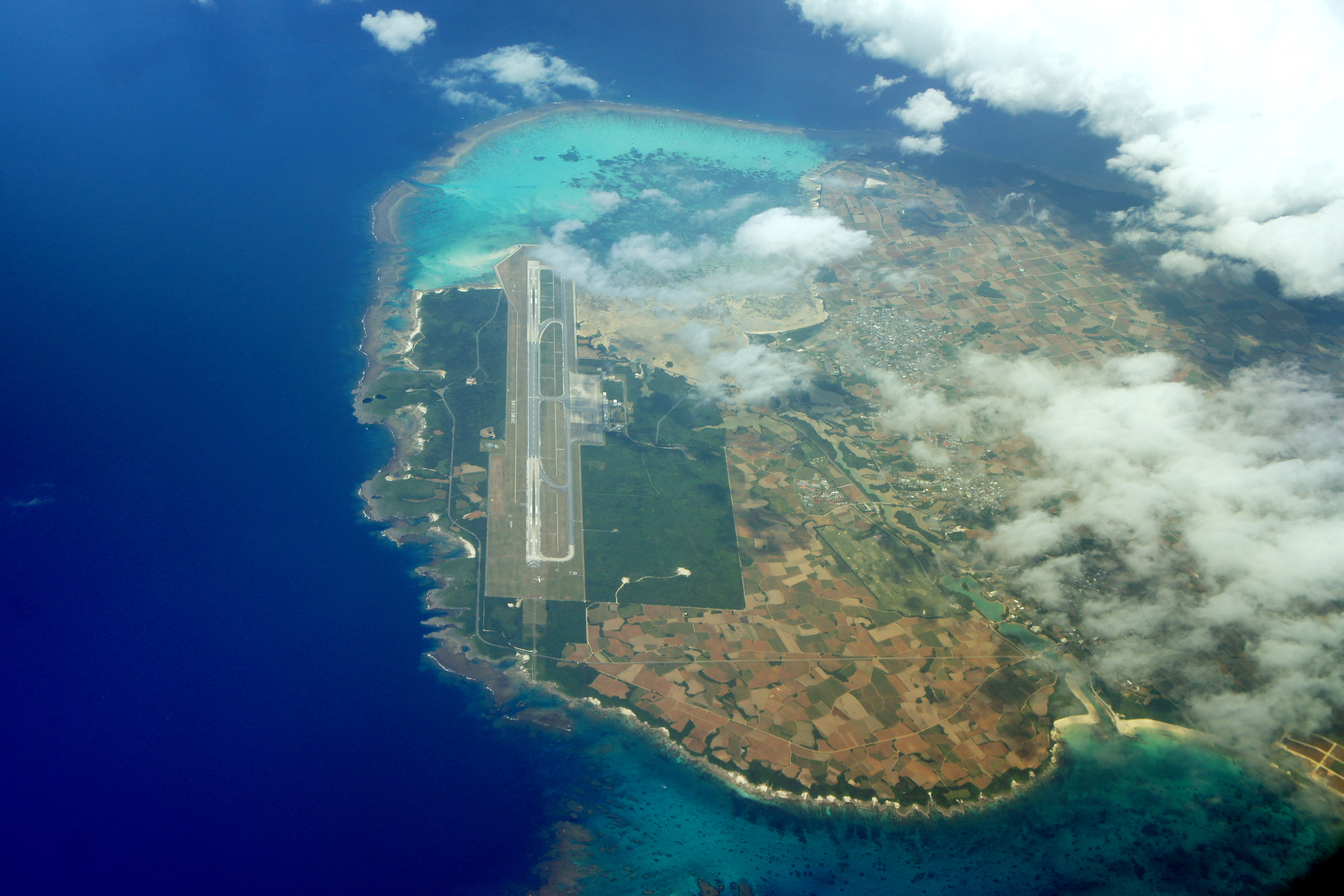
Shimojishima Airport is located on the island.
Climate
| Climate data for Shimoji-shima (2003−2020 normals, extremes 2003−present) | |||||||||||||
|---|---|---|---|---|---|---|---|---|---|---|---|---|---|
| Month | Jan | Feb | Mar | Apr | May | Jun | Jul | Aug | Sep | Oct | Nov | Dec | Year |
| Record high °C (°F) | 27.5 (81.5) |
27.5 (81.5) |
28.2 (82.8) |
29.9 (85.8) |
32.6 (90.7) |
34.2 (93.6) |
36.1 (97.0) |
35.0 (95.0) |
34.4 (93.9) |
33.6 (92.5) |
30.5 (86.9) |
28.8 (83.8) |
36.1 (97.0) |
| Average high °C (°F) | 21.2 (70.2) |
22.1 (71.8) |
23.1 (73.6) |
25.3 (77.5) |
28.2 (82.8) |
30.4 (86.7) |
32.1 (89.8) |
31.8 (89.2) |
30.9 (87.6) |
28.7 (83.7) |
26.2 (79.2) |
22.7 (72.9) |
26.9 (80.4) |
| Daily mean °C (°F) | 18.4 (65.1) |
19.1 (66.4) |
20.1 (68.2) |
22.4 (72.3) |
25.2 (77.4) |
27.8 (82.0) |
29.1 (84.4) |
28.8 (83.8) |
27.9 (82.2) |
25.8 (78.4) |
23.4 (74.1) |
20.0 (68.0) |
24.0 (75.2) |
| Average low °C (°F) | 15.9 (60.6) |
16.6 (61.9) |
17.4 (63.3) |
19.9 (67.8) |
22.9 (73.2) |
25.7 (78.3) |
26.8 (80.2) |
26.4 (79.5) |
25.5 (77.9) |
23.6 (74.5) |
21.2 (70.2) |
17.7 (63.9) |
21.6 (70.9) |
| Record low °C (°F) | 7.0 (44.6) |
6.8 (44.2) |
8.9 (48.0) |
11.8 (53.2) |
14.4 (57.9) |
18.7 (65.7) |
22.0 (71.6) |
23.1 (73.6) |
18.6 (65.5) |
16.5 (61.7) |
13.3 (55.9) |
7.3 (45.1) |
6.8 (44.2) |
| Average precipitation mm (inches) | 124.5 (4.90) |
103.5 (4.07) |
110.8 (4.36) |
142.2 (5.60) |
197.0 (7.76) |
192.0 (7.56) |
112.5 (4.43) |
262.2 (10.32) |
224.9 (8.85) |
130.5 (5.14) |
159.0 (6.26) |
120.8 (4.76) |
1,879.7 (74.00) |
| Average precipitation days (≥ 1.0 mm) | 12.2 | 10.7 | 9.7 | 9.3 | 10.5 | 10.2 | 8.3 | 12.1 | 10.3 | 9.3 | 11.0 | 11.6 | 125.2 |
| Source: JMA[2][3] | |||||||||||||
See also
References
- "Remote island related materials (離 島 関 係 資 料)" (PDF). Archived (PDF) from the original on 2020-02-15. Retrieved 2020-02-15.
- 観測史上1~10位の値(年間を通じての値). JMA. Retrieved February 24, 2022.
- 気象庁 / 平年値(年・月ごとの値). JMA. Retrieved February 24, 2022.
Naha (capital) | ||
| Core city |
| |
| Cities |
| |
| Districts |
| |
List of mergers in Okinawa Prefecture
| ||
This Okinawa Prefecture location article is a stub. You can help Wikipedia by expanding it. |
На других языках
[de] Shimoji-jima
Shimoji-jima (japanisch 下地島) ist die Nachbarinsel von Irabu-jima. Sie gehört zu den Miyako-Inseln und liegt in der Präfektur Okinawa (Japan).- [en] Shimoji-shima
[es] Isla Shimoji
La isla Shimoji (下地島, しもじしま, Shimoji-shima) es una isla perteneciente al archipiélago de las islas Miyako, dependientes de la prefectura de Okinawa, Japón.[fr] Shimoji-jima
Shimoji-jima (下地島?) est une île du Japon, une des îles Miyako dans l'archipel Sakishima.[ru] Симодзи (Мияко)
Симо́дзи (яп. 下地島 симодзи-дзима) — небольшой остров в группе Мияко островов Сакисима архипелага Рюкю, Япония. Административно относится к округу Мияко уезда Мияко префектуры Окинава.Текст в блоке "Читать" взят с сайта "Википедия" и доступен по лицензии Creative Commons Attribution-ShareAlike; в отдельных случаях могут действовать дополнительные условия.
Другой контент может иметь иную лицензию. Перед использованием материалов сайта WikiSort.org внимательно изучите правила лицензирования конкретных элементов наполнения сайта.
Другой контент может иметь иную лицензию. Перед использованием материалов сайта WikiSort.org внимательно изучите правила лицензирования конкретных элементов наполнения сайта.
2019-2026
WikiSort.org - проект по пересортировке и дополнению контента Википедии
WikiSort.org - проект по пересортировке и дополнению контента Википедии