geo.wikisort.org - Island
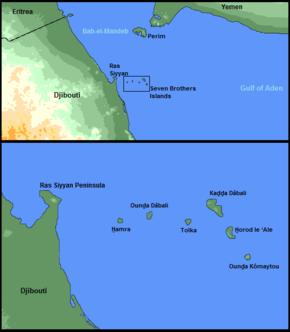
The Seven Brothers Islands, also known as the Sawabi Islands or Seba Islands, is an archipelago in the Dact-el-Mayun section of the Bab-el-Mandeb strait (between the Red Sea and the Gulf of Aden). They are within the Obock District of Djibouti, and are a notable diving site.[1] Even in English publications, the group is often called by its French name, Sept Frères.
 | |
| Geography | |
|---|---|
| Location | Bab-el-Mandeb |
| Coordinates | 12°27′46″N 43°24′06″E |
| Total islands | 6 |
| Area | 1.02 km2 (0.39 sq mi) |
| Highest elevation | 114 m (374 ft) |
| Administration | |
| Region | Obock |
Geography
The archipelago proper is a chain of six volcanic islands spanning about 10 kilometres (6.2 mi) in a rough east-west line:[2]
- West Island, or Red Island (H̱amra), 62 m high
- Double Island (Ounḏa Dâbali), 46 m high
- Low Island (Tolka), 17 m high
- Big Island (Kaḏḏa Dâbali), 114 m high
- East Island (H̱orod le ‘Ale), 83 m high
- South Island (‘Ounḏa Kômaytou), 47 m high
The "seventh brother" is not an island, but the volcanic hill at the northern tip of the Ras Siyyan peninsula.
West Island lies about 4.5 kilometres (2.8 mi) east from the Siyyan peninsula and 6.0 kilometres (3.7 mi) northeast from the coast of Djibouti.[3]
All the islets are surrounded by reefs. All are brownish, except Big Island which is yellowish.[2] There is a masonry marker on the summit of Big Island.[2]
Climate
The warmest month of the year is July with an average temperature of 39.0 °C. The archipelago consists of the main island of Kaḏḏa Dâbali, the five smaller islands of Ounḏa Dâbali, H̱amra, Tolka, H̱orod le ‘Ale and Ounḏa Kômaytou, as well as small rock outcrops that are uninhabitable by humans but important for seabirds. The sky is always clear and bright throughout the year. The climate of Seven Brothers Islands is classified in the Köppen climate classification as BWh, meaning a desert climate with a mean annual temperature over 29 °C or 84 °F.
| Climate data for Seven Brothers Islands | |||||||||||||
|---|---|---|---|---|---|---|---|---|---|---|---|---|---|
| Month | Jan | Feb | Mar | Apr | May | Jun | Jul | Aug | Sep | Oct | Nov | Dec | Year |
| Average high °C (°F) | 29.8 (85.6) |
29.8 (85.6) |
31.4 (88.5) |
33.2 (91.8) |
35.6 (96.1) |
38.2 (100.8) |
39.0 (102.2) |
38.3 (100.9) |
37.1 (98.8) |
34.4 (93.9) |
31.8 (89.2) |
30.3 (86.5) |
34.1 (93.3) |
| Average low °C (°F) | 22.6 (72.7) |
23.4 (74.1) |
24.4 (75.9) |
25.8 (78.4) |
27.9 (82.2) |
30.1 (86.2) |
30.2 (86.4) |
29.4 (84.9) |
29.5 (85.1) |
26.5 (79.7) |
23.8 (74.8) |
22.7 (72.9) |
26.4 (79.4) |
| Average rainfall mm (inches) | 4 (0.2) |
3 (0.1) |
6 (0.2) |
4 (0.2) |
1 (0.0) |
0 (0) |
5 (0.2) |
6 (0.2) |
12 (0.5) |
4 (0.2) |
4 (0.2) |
4 (0.2) |
53 (2.2) |
| Source: World Weather | |||||||||||||
References
- Alwan, Daoud Aboubaker; Mibrathu, Yohanis (2000). Historical dictionary of Djibouti. Scarecrow Press. pp. 47–. ISBN 978-0-8108-3873-4. Retrieved 28 May 2011.
- Sailing Directions (Enroute) - Red Sea and Persian Gulf, page 162. National Geospatial Intelligence Agency pub. 172. Accessed 2012-07-6.
- Dzurek, Daniel J.; University of Durham. International Boundaries Research Unit (2001). Parting the Red Sea: boundaries, offshore resources and transit. IBRU. pp. 8–. ISBN 978-1-897643-46-4. Retrieved 28 May 2011.
This Djibouti location article is a stub. You can help Wikipedia by expanding it. |
На других языках
[de] Sawabi-Inseln
Die Sawabi-Inseln (arabisch جزر السوابع Dschuzur as-Sawabiʿ, DMG Ǧuzur as-Sawābiʿ oder al-Dschuzur as-sabʿa / الجزر السبعة / al-Ǧuzur as-sabʿa /‚die sieben Inseln‘; französisch auch Sept Frères, englisch Seven Brothers ‚Sieben Brüder‘), nicht zu verwechseln mit den omanischen Sawadi-Inseln, sind eine aus sechs unbewohnten Inseln bestehende, zu Dschibuti gehörende Inselgruppe in der Meerenge Bab al-Mandab zwischen Rotem Meer und Indischem Ozean.[1] Sie gehören zur Region Obock.- [en] Seven Brothers Islands
[es] Islas Sawabi
Las islas Sawabi (en francés: 'Îles des Sept Frères') conocidas también como Seven Brothers, los «Siete hermanos»), son un grupo de pequeñas islas situadas en la costa este del Cuerno de África, en el estrecho de Bab-el-Mandeb, que separa el mar Rojo del océano Índico. Administrativamente, las islas pertenecen a la República de Yibuti.[fr] Îles des Sept Frères
Les îles des Sept Frères ou îles Sawabi sont de petites îles situées sur le territoire de Djibouti dans le détroit de Bab-el-Mandeb qui sépare la mer Rouge de l'océan Indien.[ru] Себа (острова)
Острова Себа (также Саваби или архипелаг «Семь братьев») — архипелаг в Джибути в Баб-эль-Мандебском проливе. Архипелаг состоит из шести островов, а седьмой «брат» — это вулканический холм на северной оконечности полуостров Рас-Сийян.Другой контент может иметь иную лицензию. Перед использованием материалов сайта WikiSort.org внимательно изучите правила лицензирования конкретных элементов наполнения сайта.
WikiSort.org - проект по пересортировке и дополнению контента Википедии