geo.wikisort.org - Island
Sado Island (Japanese:佐渡島/さどがしま Sadogashima ) is an island located in the eastern part of the Sea of Japan, under the jurisdiction of Sado City, Niigata Prefecture, Japan, with a coastline of 262.7 kilometres (163.2 mi). In October 2017, Sado Island had a population of 55,212 people. Sado Island covers an area of 854.76 km2 (330.02 sq mi), and is the second largest island after Okinawa Island outside of the four main islands of Japan, excluding the disputed Southern Kurils.[1] The shortest distance between Sado Island and Honshu is 32 km (20 mi).[2] The highest peak on Sado Island is Mount Kinpoku, with an elevation of 1,172 m (3,845 ft).[3]
This article may be expanded with text translated from the corresponding article in Japanese. (February 2022) Click [show] for important translation instructions.
|
Native name: 佐渡島 | |
|---|---|
 | |
| Geography | |
| Location | Japanese Archipelago |
| Coordinates | 38°04′03″N 138°23′51″E |
| Area | 854.76[1] km2 (330.02 sq mi) |
| Highest elevation | 1,172 m (3845 ft) |
| Highest point | Mount Kinpoku |
| Administration | |
Sado, Niigata, | |
Geography
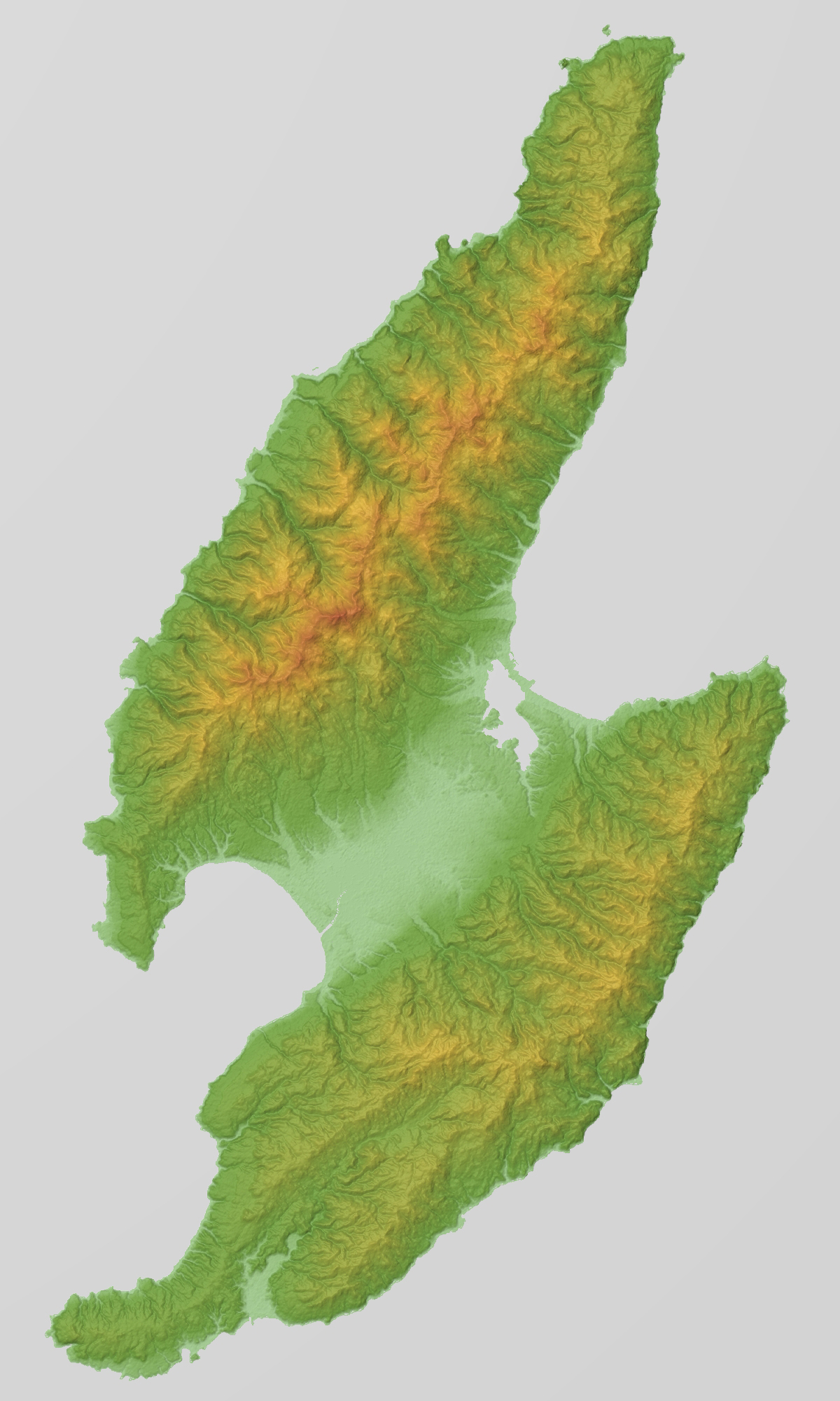
The shape of Sado Island resembles the word ‘work’ (工) in Japanese or the letter ‘S’. The topography of the island can be roughly divided into three parts, the Ōsado range in the north, the Kosado range in the south, and the Kakakura plain with flat terrain in between. The Ōsado range area is higher in altitude, and the highest peak of Sado Island, Mount Kinpoku (1,172 m (3,845 ft) above sea level), is also located in this area. The coastline on the north side of Mount Sado is steep, and is a famous tourist spot, among which the Senkaku Bay is the most famous.[4] The Kosado range has a relatively flatter terrain with Satsuma orange and tea trees growing there. Its highest peak is Mount Ōjiyama, with an elevation of 646 m (2,119 ft).[5] The Nakakura Plain is a large plain in Japan's outlying islands and is also the agricultural area of Sado Island. On the west side of the Kuninaka Plain is Mano Bay, and on the east side is Ryōtsu Bay. The Kokufugawa River (also reads Konogawa River) flows through the Kuninaka Plain, with a total length of 19 km (12 mi), and flows into Mano Bay. Its watershed area accounts for 20% of Sado Island.[6] Lake Kamo, the largest lake in Niigata Prefecture, is located at the eastern end of the Kuninaka Plain. Lake Kamo was originally a freshwater lake, and later turned into a lagoon after an opening built to the Sea of Japan. Oyster breeding flourishes in the lake.[7] Part of Sado Island belongs to the Sado-Yahiko-Yoneyama Quasi-National Park.[8]
 Futatsugame Tombolo
 Onogame
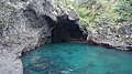 Kotoura Cave (Ryuodo Cave) in Ogi Coast
 Senkaku Bay (Senkakuwan)
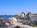 Nanaura Coast


Weather and Climate
Affected by the warm Black Current that passes through the Sado waters, the winter in Sado Island is warmer than that in Niigata Prefecture and with less snow. In summer, due to the influence of ocean, the temperature difference between day and night is smaller than that of Niigata Prefecture, and is cooler than that of Niigata Prefecture. However, the Aikawa area on the northwestern side of the Ōsado range are affected by the monsoon blowing from the northwest and the temperature is higher. Precipitation on Sado Island is mainly concentrated in the end of the East Asian rainy season and early winter, and there is less precipitation than in Niigata Prefecture. When the low air pressure and typhoons pass through the Sea of Japan, Sado Island often suffers from Foehn wind, raising the temperature sharply. Located at the junction of the warm and cold current, Sado City enjoys diverse plants and rich aquatic resources.
| Climate data for Aikawa, Sado, Niigata, 1991−2020 normals, extremes 1911−present | |||||||||||||
|---|---|---|---|---|---|---|---|---|---|---|---|---|---|
| Month | Jan | Feb | Mar | Apr | May | Jun | Jul | Aug | Sep | Oct | Nov | Dec | Year |
| Record high °C (°F) | 17.0 (62.6) |
20.7 (69.3) |
22.3 (72.1) |
28.0 (82.4) |
30.0 (86.0) |
34.1 (93.4) |
37.4 (99.3) |
38.1 (100.6) |
37.4 (99.3) |
31.5 (88.7) |
26.3 (79.3) |
22.9 (73.2) |
38.1 (100.6) |
| Average high °C (°F) | 6.5 (43.7) |
6.7 (44.1) |
9.6 (49.3) |
14.9 (58.8) |
19.9 (67.8) |
23.3 (73.9) |
27.1 (80.8) |
29.3 (84.7) |
25.9 (78.6) |
20.5 (68.9) |
15.0 (59.0) |
9.7 (49.5) |
17.4 (63.3) |
| Daily mean °C (°F) | 4.0 (39.2) |
4.0 (39.2) |
6.5 (43.7) |
11.1 (52.0) |
15.9 (60.6) |
19.8 (67.6) |
24.0 (75.2) |
26.0 (78.8) |
22.5 (72.5) |
17.2 (63.0) |
11.8 (53.2) |
6.8 (44.2) |
14.1 (57.4) |
| Average low °C (°F) | 1.3 (34.3) |
1.0 (33.8) |
2.9 (37.2) |
7.2 (45.0) |
12.0 (53.6) |
16.6 (61.9) |
21.3 (70.3) |
22.9 (73.2) |
19.2 (66.6) |
13.6 (56.5) |
8.2 (46.8) |
3.8 (38.8) |
10.8 (51.5) |
| Record low °C (°F) | −7.5 (18.5) |
−7.4 (18.7) |
−6.4 (20.5) |
−2.1 (28.2) |
2.5 (36.5) |
7.6 (45.7) |
12.1 (53.8) |
14.6 (58.3) |
9.5 (49.1) |
4.4 (39.9) |
−2.8 (27.0) |
−6.6 (20.1) |
−7.5 (18.5) |
| Average precipitation mm (inches) | 131.1 (5.16) |
91.6 (3.61) |
96.6 (3.80) |
94.5 (3.72) |
97.3 (3.83) |
122.5 (4.82) |
207.3 (8.16) |
137.5 (5.41) |
139.9 (5.51) |
133.1 (5.24) |
154.8 (6.09) |
175.7 (6.92) |
1,581.9 (62.27) |
| Average snowfall cm (inches) | 28 (11) |
25 (9.8) |
4 (1.6) |
0 (0) |
0 (0) |
0 (0) |
0 (0) |
0 (0) |
0 (0) |
0 (0) |
0 (0) |
9 (3.5) |
66 (25.9) |
| Average rainy days | 19.7 | 15.3 | 14.0 | 10.3 | 9.7 | 9.0 | 10.9 | 8.7 | 10.4 | 12.3 | 16.6 | 20.9 | 157.8 |
| Average snowy days | 7.1 | 6.8 | 1.4 | 0 | 0 | 0 | 0 | 0 | 0 | 0 | 0 | 2.5 | 17.8 |
| Average relative humidity (%) | 69 | 68 | 66 | 67 | 72 | 78 | 81 | 77 | 73 | 69 | 68 | 69 | 71 |
| Mean monthly sunshine hours | 46.2 | 69.2 | 133.1 | 177.0 | 200.7 | 178.4 | 161.2 | 207.8 | 157.0 | 147.5 | 95.8 | 50.6 | 1,624.5 |
| Source 1: JMA[9] | |||||||||||||
| Source 2: JMA[10] | |||||||||||||
| Climate data for Cape Hajikizaki[lower-alpha 1], 38°19.8′N 138°30.7′E, 1991−2020 normals, extremes 1978−present | |||||||||||||
|---|---|---|---|---|---|---|---|---|---|---|---|---|---|
| Month | Jan | Feb | Mar | Apr | May | Jun | Jul | Aug | Sep | Oct | Nov | Dec | Year |
| Record high °C (°F) | 16.1 (61.0) |
22.4 (72.3) |
24.6 (76.3) |
28.0 (82.4) |
29.9 (85.8) |
30.0 (86.0) |
34.3 (93.7) |
35.0 (95.0) |
35.3 (95.5) |
29.7 (85.5) |
23.4 (74.1) |
18.7 (65.7) |
35.3 (95.5) |
| Average high °C (°F) | 5.4 (41.7) |
5.8 (42.4) |
9.1 (48.4) |
14.2 (57.6) |
19.0 (66.2) |
22.4 (72.3) |
26.2 (79.2) |
28.2 (82.8) |
24.8 (76.6) |
19.5 (67.1) |
14.0 (57.2) |
8.5 (47.3) |
16.4 (61.6) |
| Daily mean °C (°F) | 3.1 (37.6) |
3.1 (37.6) |
5.7 (42.3) |
10.4 (50.7) |
15.1 (59.2) |
19.0 (66.2) |
23.1 (73.6) |
25.0 (77.0) |
21.8 (71.2) |
16.5 (61.7) |
11.0 (51.8) |
5.9 (42.6) |
13.3 (56.0) |
| Average low °C (°F) | 0.7 (33.3) |
0.5 (32.9) |
2.5 (36.5) |
6.8 (44.2) |
11.4 (52.5) |
15.8 (60.4) |
20.5 (68.9) |
22.2 (72.0) |
18.9 (66.0) |
13.4 (56.1) |
7.9 (46.2) |
3.2 (37.8) |
10.3 (50.6) |
| Record low °C (°F) | −6.3 (20.7) |
−7.0 (19.4) |
−3.3 (26.1) |
−0.8 (30.6) |
2.1 (35.8) |
7.5 (45.5) |
12.3 (54.1) |
15.5 (59.9) |
9.5 (49.1) |
4.2 (39.6) |
−0.6 (30.9) |
−4.9 (23.2) |
−7.0 (19.4) |
| Average precipitation mm (inches) | 133.1 (5.24) |
94.3 (3.71) |
101.0 (3.98) |
104.1 (4.10) |
112.3 (4.42) |
127.2 (5.01) |
216.2 (8.51) |
154.0 (6.06) |
152.5 (6.00) |
161.1 (6.34) |
167.7 (6.60) |
180.9 (7.12) |
1,711.6 (67.39) |
| Average precipitation days (≥ 1.0 mm) | 20.3 | 16.2 | 14.6 | 11.3 | 10.4 | 10.0 | 11.7 | 9.6 | 11.6 | 13.7 | 16.6 | 21.6 | 167.6 |
| Mean monthly sunshine hours | 46.1 | 77.7 | 149.8 | 200.1 | 218.7 | 189.0 | 171.9 | 215.7 | 159.9 | 149.2 | 92.0 | 51.0 | 1,723.5 |
| Source: Japan Meteorological Agency[11][12] | |||||||||||||
| Climate data for Ryōtsu (1991−2020 normals, extremes 1978−present) | |||||||||||||
|---|---|---|---|---|---|---|---|---|---|---|---|---|---|
| Month | Jan | Feb | Mar | Apr | May | Jun | Jul | Aug | Sep | Oct | Nov | Dec | Year |
| Record high °C (°F) | 14.2 (57.6) |
19.9 (67.8) |
20.5 (68.9) |
26.9 (80.4) |
29.0 (84.2) |
30.7 (87.3) |
37.7 (99.9) |
38.8 (101.8) |
38.2 (100.8) |
29.5 (85.1) |
23.9 (75.0) |
19.0 (66.2) |
38.8 (101.8) |
| Average high °C (°F) | 5.8 (42.4) |
6.2 (43.2) |
9.5 (49.1) |
14.7 (58.5) |
19.7 (67.5) |
23.4 (74.1) |
27.4 (81.3) |
29.6 (85.3) |
26.2 (79.2) |
20.6 (69.1) |
14.6 (58.3) |
8.8 (47.8) |
17.2 (63.0) |
| Daily mean °C (°F) | 3.0 (37.4) |
3.1 (37.6) |
5.9 (42.6) |
10.8 (51.4) |
15.8 (60.4) |
20.0 (68.0) |
24.2 (75.6) |
26.1 (79.0) |
22.5 (72.5) |
16.8 (62.2) |
11.0 (51.8) |
5.7 (42.3) |
13.7 (56.7) |
| Average low °C (°F) | 0.2 (32.4) |
0.0 (32.0) |
2.2 (36.0) |
6.9 (44.4) |
12.2 (54.0) |
17.0 (62.6) |
21.5 (70.7) |
23.0 (73.4) |
19.2 (66.6) |
13.1 (55.6) |
7.3 (45.1) |
2.5 (36.5) |
10.4 (50.8) |
| Record low °C (°F) | −6.9 (19.6) |
−7.1 (19.2) |
−4.5 (23.9) |
−1.0 (30.2) |
3.6 (38.5) |
10.4 (50.7) |
13.8 (56.8) |
16.4 (61.5) |
10.8 (51.4) |
3.7 (38.7) |
−0.8 (30.6) |
−4.6 (23.7) |
−7.1 (19.2) |
| Average precipitation mm (inches) | 164.3 (6.47) |
118.7 (4.67) |
109.1 (4.30) |
104.6 (4.12) |
107.3 (4.22) |
138.9 (5.47) |
233.2 (9.18) |
142.7 (5.62) |
136.7 (5.38) |
139.2 (5.48) |
155.2 (6.11) |
210.0 (8.27) |
1,758.5 (69.23) |
| Average precipitation days (≥ 1.0 mm) | 23.0 | 18.1 | 15.7 | 11.7 | 9.7 | 9.3 | 11.4 | 9.1 | 11.4 | 12.9 | 16.9 | 22.7 | 171.9 |
| Mean monthly sunshine hours | 52.9 | 79.1 | 140.7 | 190.9 | 216.5 | 185.1 | 177.9 | 219.5 | 159.9 | 150.9 | 99.3 | 56.9 | 1,735.7 |
| Source: Japan Meteorological Agency[13][14] | |||||||||||||
| Climate data for Hamo (1991−2020 normals, extremes 1978−present) | |||||||||||||
|---|---|---|---|---|---|---|---|---|---|---|---|---|---|
| Month | Jan | Feb | Mar | Apr | May | Jun | Jul | Aug | Sep | Oct | Nov | Dec | Year |
| Record high °C (°F) | 15.2 (59.4) |
20.0 (68.0) |
21.6 (70.9) |
28.4 (83.1) |
30.6 (87.1) |
34.4 (93.9) |
37.6 (99.7) |
38.2 (100.8) |
36.2 (97.2) |
31.7 (89.1) |
24.1 (75.4) |
19.6 (67.3) |
38.2 (100.8) |
| Average high °C (°F) | 6.0 (42.8) |
6.4 (43.5) |
9.8 (49.6) |
15.6 (60.1) |
21.0 (69.8) |
24.5 (76.1) |
28.0 (82.4) |
30.2 (86.4) |
26.4 (79.5) |
20.7 (69.3) |
14.8 (58.6) |
9.1 (48.4) |
17.7 (63.9) |
| Daily mean °C (°F) | 3.1 (37.6) |
3.0 (37.4) |
5.6 (42.1) |
10.6 (51.1) |
15.7 (60.3) |
19.9 (67.8) |
23.9 (75.0) |
25.6 (78.1) |
21.7 (71.1) |
16.0 (60.8) |
10.5 (50.9) |
5.7 (42.3) |
13.4 (56.2) |
| Average low °C (°F) | 0.2 (32.4) |
−0.2 (31.6) |
1.4 (34.5) |
5.8 (42.4) |
11.0 (51.8) |
15.9 (60.6) |
20.6 (69.1) |
21.9 (71.4) |
18.0 (64.4) |
11.9 (53.4) |
6.6 (43.9) |
2.5 (36.5) |
9.6 (49.3) |
| Record low °C (°F) | −7.5 (18.5) |
−7.4 (18.7) |
−4.9 (23.2) |
−2.9 (26.8) |
2.2 (36.0) |
7.8 (46.0) |
12.2 (54.0) |
14.2 (57.6) |
9.1 (48.4) |
2.4 (36.3) |
0.2 (32.4) |
−3.9 (25.0) |
−7.5 (18.5) |
| Average precipitation mm (inches) | 164.0 (6.46) |
109.5 (4.31) |
107.2 (4.22) |
98.7 (3.89) |
98.0 (3.86) |
129.6 (5.10) |
210.9 (8.30) |
143.8 (5.66) |
142.7 (5.62) |
138.2 (5.44) |
173.0 (6.81) |
206.3 (8.12) |
1,721.7 (67.78) |
| Average precipitation days (≥ 1.0 mm) | 22.8 | 17.7 | 16.1 | 11.6 | 10.3 | 9.6 | 12.2 | 9.5 | 11.5 | 13.6 | 17.5 | 22.4 | 174.8 |
| Mean monthly sunshine hours | 56.8 | 80.6 | 143.3 | 185.4 | 205.4 | 172.8 | 164.1 | 202.8 | 148.7 | 146.5 | 103.7 | 57.8 | 1,667.8 |
| Source: Japan Meteorological Agency[15][16] | |||||||||||||
History

With a long history, Sado Island has been inhabited by humans since 10,000 years ago. Thousands of ruins discovered in the Kanai area includes stoneware and hunting equipment from the late Yayoi period. There are also records of Sado in the Kojiki and Nihongi. After the Taika Reform, the central government established the Sado Province on the island, and the local population began to emigrate to Sado Island. At the same time, Sado Island has also become the place where losers of political conflicts or dissidents were exiled. Emperor Juntoku, Nichiren and other people had been exiled to Sado. After the Kamakura period, the Honma clan was appointed as the Shugodai. After 1589 ( Tenshō 17), Uesugi Kagekatsu invaded Sado Island, after which Sado Island was dominated by the Uesugi clan.
In 1601, the miners discovered the gold and silver veins in the Aikawa Tsuruko Ginzan, which is the Sado Mine, for which the status of Sado Island made a great leap. In 1603 (Keichō 8), Tokugawa Ieyasu classified Sado Island as a territory of Bakufu immediately after the victory of the Battle of Sekigahara. Since then, Sado Mine has developed into the largest gold mine in Japan, and the gold output reached 41 tons by Bakumatsu, and played an important role in the finance of the Shogunate. After the middle of the Edo period, the exploitation quantity began to decrease. However, the output returned to the highest level ever of 400 kg per year thanks to the introduction of advanced excavation technology in the Meiji era. In 1989, Sado Gold Mine closed. In nearly 400 years of mining history, it has produced 78 tons of gold and 2,300 tons of silver.
After the Abolition of the han system, the Japanese government established Sado Prefecture on Sado Island (later renamed as Aikawa Prefecture). In 1876, Aikawa Prefecture was incorporated into Niigata Prefecture. In 2004, 10 cities, towns and villages on Sado Island merged into Sado City.
Population
In 1960, Sado Island had a population of 113,296. Due to the inconvenience of living on the outlying islands and lack of jobs, Sado Island has been experiencing a long-term population decline. In October 2017, the population of Sado Island was 55,212. The total fertility rate of Sado Island is about 1.9, which is much higher than the average of Japan and Niigata Prefecture. However, the continuous outflow of population results in the persistent decrease of population.
Culture


Since Sado Island is an important trading base on the Nishimawari naval route from the coast of the Japan Sea to Osaka, the culture is strongly influenced by West Japanese culture like Kinki and Hokuriku. Also, intellectuals and politicians exiled from Kyoto to Sado brought the traditional performance culture of Kyoto, thus the traditional art of Sado Island began to thrive. The Noh Master Zeami Motokiyo was exiled to Sado, resulting in the particular development of Noh culture in Sado. In the Edo period, there were more than 200 Noh stages. Sado still has more than 30 Noh stages, and the number of Noh stages per capita ranks first in Japan. There are also local performing arts such as ‘Ghost Taiko’ on Sado Island.
Sado is also home to the Kodō taiko drumming troupe.[17] Kodō are credited with popularizing modern taiko drumming both in Japan and worldwide. Kodō Village is based in the Ogi subdivision.
Transportation
See also
- Sado, Niigata (municipality)
References
- 島面積20傑 (PDF) (in Japanese). 国土地理院. Retrieved 2017-07-08. [permanent dead link]
- 佐渡島の概況 (in Japanese). 新潟県. Retrieved 2017-07-08. [permanent dead link]
- 金北山 (in Japanese). 山と渓谷社. Retrieved 2017-07-08.
- 尖閣湾 (in Japanese). 佐渡観光協会. Retrieved 2017-07-09. [permanent dead link]
- 大地山 (in Japanese). 山と溪谷社. Retrieved 2017-07-09.
- 国府川水系河川整備計画 (PDF) (in Japanese). 新潟県. Retrieved 2017-07-09. [permanent dead link]
- 加茂湖 (in Japanese). 佐渡観光協会. Retrieved 2017-07-09.
- 佐渡地域区域図及び公園計画図 (PDF) (in Japanese). 新潟県. Retrieved 2017-07-09. [permanent dead link]
- "Aikawa Climate Normals 1991-2020". JMA. Retrieved February 18, 2022.
- "Aikawa Climate Extremes". JMA. Retrieved February 18, 2022.
- 観測史上1~10位の値(年間を通じての値). JMA. Retrieved March 6, 2022.
- 気象庁 / 平年値(年・月ごとの値). JMA. Retrieved March 6, 2022.
- 観測史上1~10位の値(年間を通じての値). JMA. Retrieved March 15, 2022.
- 気象庁 / 平年値(年・月ごとの値). JMA. Retrieved March 15, 2022.
- 観測史上1~10位の値(年間を通じての値). JMA. Retrieved March 15, 2022.
- 気象庁 / 平年値(年・月ごとの値). JMA. Retrieved March 15, 2022.
- Henry Mabley Johnson; Jerry C. Jaffe (2008). Performing Japan: Contemporary Expressions of Cultural Identity. Global Oriental. p. 37. ISBN 1905246315.
Notes
- Japanese: 弾崎
External links
- Sado Tourism Association (in English)
- Sado Geopark (in English)
- Sado Steam Ship (in English)
Authority control | |
|---|---|
| General | |
| National libraries | |
На других языках
[de] Sado (Insel)
Sado (japanisch 佐渡島, Sado-ga-shima oder Sado-shima) ist eine japanische Insel, der Westküste Honshūs vorgelagert.- [en] Sado Island
[es] Isla Sado
La isla Sado (en japonés, 佐渡島 - 佐渡ヶ島) es una pequeña isla costera de Japón que se encuentra en aguas del mar de Japón frente a la costa occidental de la gran isla de Honshū, de la que la separa el estrecho de Sado. Administrativamente pertenece a la región de Chubu de la prefectura de Niigata. Desde 2004 la ciudad ha compuesto también toda la isla, aunque no todos los 855,26 km² de su área total están urbanizados. Sado, por superficie, es la sexta isla más grande del país después de la isla de Okinawa, y excluyendo los territorios del Norte.[fr] Sadoga-shima
Sadoga-shima (japonais : 佐渡島) est une île de la préfecture de Niigata, au Japon. Ell appartient à la ville de Sado. C'est la plus grande île de la mer du Japon.[it] Isola di Sado
Sado (佐渡島/さどがしま Sadogashima) è un'isola giapponese situata nella regione di Chūbu e precisamente ad ovest della prefettura di Niigata. Per dimensioni è la sesta isola dell'arcipelago giapponese.[ru] Садо (остров)
Садо (яп. 佐渡島 Садогасима, «садосский остров») — остров в восточной части Японского моря. Принадлежит префектуре Ниигата, Япония. Является восьмым по величине японским островом.Другой контент может иметь иную лицензию. Перед использованием материалов сайта WikiSort.org внимательно изучите правила лицензирования конкретных элементов наполнения сайта.
WikiSort.org - проект по пересортировке и дополнению контента Википедии