geo.wikisort.org - Island
Raa Atoll (also known as Northern Maalhosmadulu Atoll or Maalhosmadulu Uthuruburi) is an administrative division from the Maldives. The capital is Ungoofaaru. It includes Northern Maalhosmadulu Atoll proper and the island of Alifushi.
Raa Atoll | |
|---|---|
 | |
| Country | Maldives |
| Corresponding geographic atoll(s) | Maalhosmadulu Uthuruburi |
| Location | 5° 58' N and 5° 20' N |
| Capital | Ungoofaaru |
| Government | |
| • Atoll Chief | Ali Shahid |
| Population | |
| • Total | 24,862 |
| Letter code | E |
| Dhivehi letter code | R (ރ) |
| • Number of islands | 88 |
| • Inhabited islands | Alifushi * Angolhitheemu * Dhuvaafaru * Fainu * Hulhudhuffaaru * Inguraidhoo * Innamaadhoo * Kinolhas * Maakurathu * Maduvvaree * Maamigili * Meedhoo * Rasgetheemu * Rasmaadhoo * Ungoofaaru * Vaadhoo * Kandholhudhoo |
| • Uninhabited islands | Aarah, Arilundhoo, Badaveri, Bodufarufinolhu, Bodufenmaaenboodhoo, Bodufushi, Boduhaiykodi, Boduhuraa, Ekurufushi, Etthingili, Dhigali, Dhoragali, Dheburidheythereyvaadhoo, Dhikkurendhdhoo, Dhinnaafushi, Dhuvaafaruhuraa, Faarafushi, Fasmendhoo, Fenfushi, Filaidhoo, Fuggiri, Furaveri, Gaaudoodhoo, Giraavaru, Goyyafaru, Guboshi, Hiraveri, Hulhudhoo, Huruvalhi, Ifuru, Kaddogadu, Kothaifaru, Kottafaru, Kottefaru, Kudafushi, Kudahaiykodi, Kudakurathu, Kudalhosgiri, Kudathulhaadhoo, Kukulhudhoo, Kuroshigiri, Lhaanbugali, Lhaanbugau, Lhohi, Liboakandhoo, Lundhufushi, Maafaru, Maamunagaufinolhu, Maanenfushi, Maashigiri, Madivaafaru, Mahidhoo, Meedhupparu, Muravandhoo, Mullaafushi, Neyo, Thaavathaa, Ufulandhoo, Ugulu, Uthurumaafaru, Vaffushihuraa, Vandhoo, Veyvah, Viligili, Wakkaru |
| Resort islands(*), airports(¤) and industrial islands are also considered uninhabited. | |
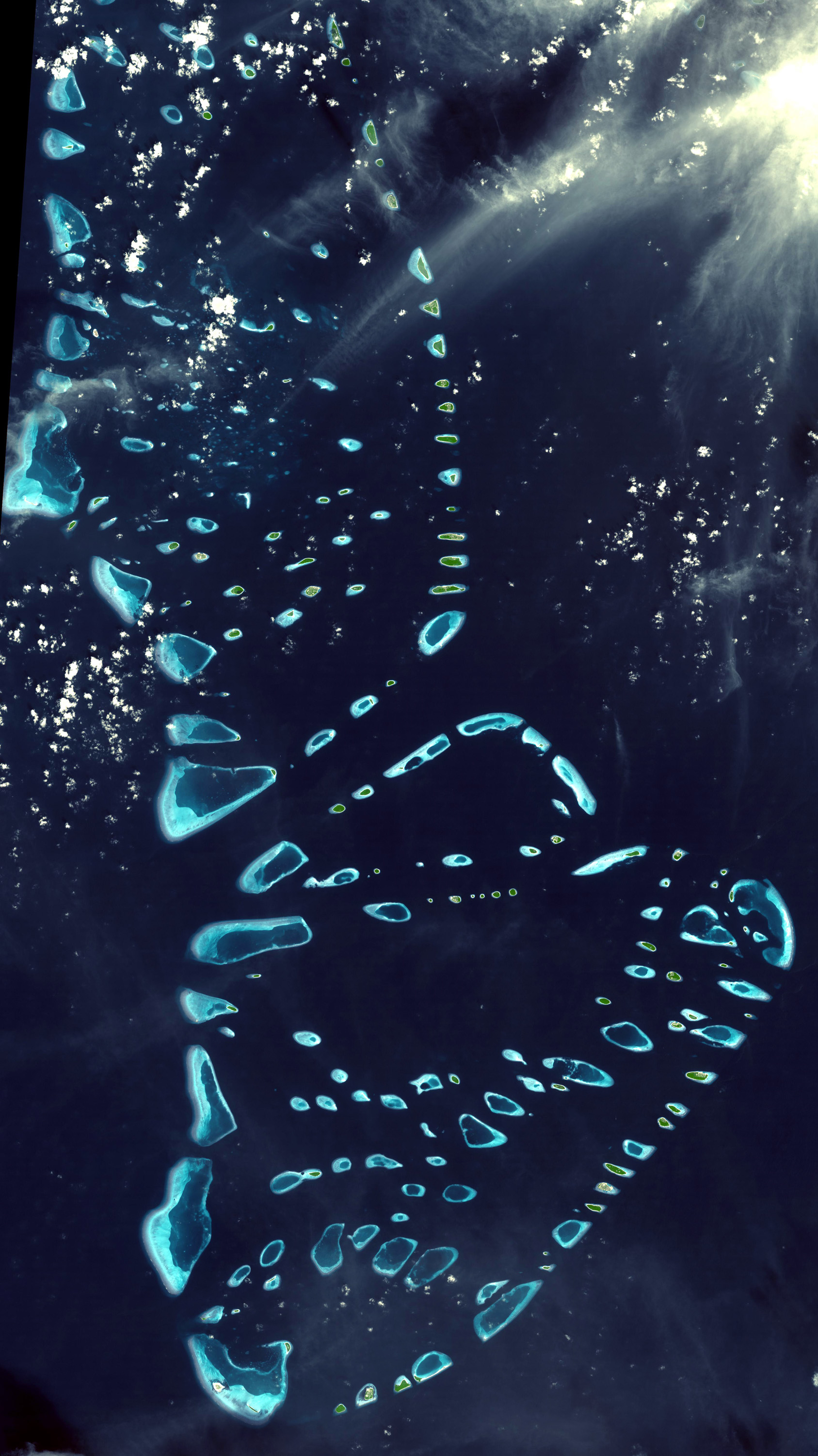
1. Alifushi and Etthingili (Powell Islands in the Admiralty Chart) stand on a detached reef of their own with very deep waters (no sounding) between this faru and the northern end of the main atoll.
2. Northern Maalhosmadulu Atoll is 35 miles (56 km) in length from N to S, and 15 miles (24 km) across at its broadest part. Its western fringe is composed of a series of round or oval reefs (farus) irregularly placed (a feature peculiar to all the larger Northern Atolls). The centre is heavily dotted with coral patches (giri), some submerged and some awash. The concentration of giri is especially dense towards its SW quarter, close to Kandholhudhu Island (where there is the place most crowded with small reefs and shoals in the whole Maldives), but its narrower northern end is quite clear of reefs. The general depths of the lagoon are from 23 to 27 fathoms (138 to 162 ft; 42 to 49 m).
The capital of Northern Maalhosmadulu Atoll is Ungoofaaru. Recently, the island has been reclaimed up to the edge of the reef in order to provide land for social and economic activities for the growing population.
NOTE: Haa Alifu, Haa Dhaalu, Shaviyani, Noonu, Raa, Baa, Kaafu, etc. are code letters assigned to the present administrative divisions of the Maldives. They are not the proper names of the natural atolls that make up these divisions. Some atolls are divided into two administrative divisions while other divisions are made up of two or more natural atolls. The order followed by the code letters is from North to South, beginning with the first letters of the Thaana alphabet used in Dhivehi. These code letters are not accurate from the geographical and cultural point of view. However, they have become popular among tourists and foreigners in the Maldives who find them easier to pronounce than the true atoll names in Dhivehi, (save a few exceptions, like Ari Atoll).[1]
Alifushi, located at the northern end of the atoll, is an island which has been traditionally famous for its skilled boatbuilding carpenters. It now houses shipyards.

Moresby Channel (Hanikandu)
Hanikandu is the channel between Northern Maalhosmadulu Atoll and "Fasdhūtere" Atoll, beyond its southern border. This channel is also known as Moresby Channel in the honor of Robert Moresby, an almost forgotten captain and draughtsman, who with much patience and hard work charted all the Atolls of the Maldives.
Tourism
Formerly this atoll was off-limits for tourists; since the late 1990s there was a change in government policy. The main tourist resort islands are Loama Maamigili and Meedhupparu.
References
- Tim Godfrey, Atlas of the Maldives, Atoll Editions 2004
- Divehi Tārīkhah Au Alikameh. Divehi Bahāi Tārikhah Khidmaiykurā Qaumī Markazu. Reprint 1958 edn. Malé 1990.
- Divehiraajjege Jōgrafīge Vanavaru. Muhammadu Ibrahim Lutfee. G.Sōsanī.
- Xavier Romero-Frias, The Maldive Islanders, A Study of the Popular Culture of an Ancient Ocean Kingdom. Barcelona 1999.
First-level administrative divisions of the Maldives | ||
|---|---|---|
| Atolls |
|  |
| Cities | ||
На других языках
- [en] Raa Atoll
[ru] Раа
Атолл Раа (мальд. މާޅޮސްމަޑުލު އުތުރުބުރި), или атолл Северный Малосмадулу, — административная единица Мальдивских островов. Она включает в себя природный атолл Северный Маалхосмадулу и остров Алифуши. Административный центр атолла Раа располагается на острове Унгуфару.Другой контент может иметь иную лицензию. Перед использованием материалов сайта WikiSort.org внимательно изучите правила лицензирования конкретных элементов наполнения сайта.
WikiSort.org - проект по пересортировке и дополнению контента Википедии