geo.wikisort.org - Island
Pulau Indah ("Beautiful Island", formerly known as Pulau Lumut) is an island in Klang District, Selangor, Malaysia with a population of around 20,000 people overall. Malaysia's largest port, West Port, Port Klang, is on the island.[1]
This article needs additional citations for verification. (October 2015) |
 Pulau Indah railway station | |
 Pulau Indah | |
| Geography | |
|---|---|
| Location | Strait of Malacca |
| Coordinates | 2°56′56″N 101°19′54″E |
| Administration | |
Malaysia | |
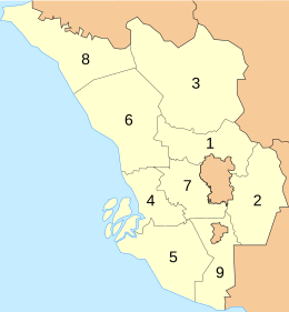
| State | Selangor |
| District | Klang |
| Demographics | |
| Population | 20,000 |
There are two bridges linking the island to the mainland: the Pulau Indah Expressway ![]() bridge which is an extension of the KESAS
bridge which is an extension of the KESAS ![]() after Pandamaran; and the SKVE
after Pandamaran; and the SKVE ![]() bridge which links Pulau Indah to Carey Island and to Teluk Panglima Garang. Prior to the completion of the bridges, the only mode of transportation for the island inhabitants was a regular one-hour ferry service to Port Klang Terminal.
bridge which links Pulau Indah to Carey Island and to Teluk Panglima Garang. Prior to the completion of the bridges, the only mode of transportation for the island inhabitants was a regular one-hour ferry service to Port Klang Terminal.
There is a KTM station, connected to the rest of Port Klang Line by a bridge parallel to the Pulau Indah Expressway, but the station is for cargo use only and not open to passengers.
In addition to West Port, Pulau Indah primarily contains Pulau Indah Industrial Park (including Selangor Halal Hub, developed by Central Spetrum (M) Sdn Bhd, a subsidiary of Kumpulan Hartanah Selangor Bhd, which in turn is wholly-owned by Menteri Besar Selangor (Incorporated)), four local villages (Kg. Perigi Nenas, Kg. Sungai Pinang, Kg. Sungai Kembong, Kg. Teluk Nipah), a seaside park (Laguna Park), a housing estate (Bandar Armada Putra), and the Malaysian Navy's Pusat Hidrografi Nasional.[2][3]
Pulau Indah had significant mangrove swamps, but most of the mangroves were lost by 1999 for the development of West Port and industrial estates.[4][5]
Gallery
 Lumut Straits
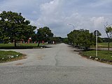 Laguna Park
 Jalan Lingkaran Pulau Indah
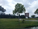 Orang Asli Village in Pulau Indah.
 Pulau Indah Expressway


See also
References
- "Growth in Pulau Indah".
- "Pulau Indah's time to shine". Edgeprop.my.
- "Pulau Indah Industrial Park".
- Mangrove and Coastal Environment of Selangor, Malaysia: Physical Features and Hydrography, Chong, V.C, King, B., and Wolanski, E.
- "Flora and Fauna of Klang Islands Mangrove Forest Reserves, Selangor, Malaysia,Norhayati, A., Shukor, M.N., Juliana, S., and Wan Juliana, W.A., Malaysian Journal of Science 28(3): 275 –288(2009)" (PDF).
State of Selangor | |||||||||||||||||
|---|---|---|---|---|---|---|---|---|---|---|---|---|---|---|---|---|---|
Capital: Shah Alam | |||||||||||||||||
| General topics |
|  | |||||||||||||||
| Administrative divisions | 9 Districts and 12 Local governments (3 Cites, 8 Municipals, 1 District) Special zone: Klang Valley conurbation · Multimedia Super Corridor | ||||||||||||||||
| City councils (Majlis Bandaraya) |
| ||||||||||||||||
| Municipal councils (Majlis Perbandaran) |
| ||||||||||||||||
| District councils (Majlis Daerah) |
| ||||||||||||||||
| |||||||||||||||||
This article about an island of Malaysia is a stub. You can help Wikipedia by expanding it. |
This Selangor location article is a stub. You can help Wikipedia by expanding it. |
Другой контент может иметь иную лицензию. Перед использованием материалов сайта WikiSort.org внимательно изучите правила лицензирования конкретных элементов наполнения сайта.
WikiSort.org - проект по пересортировке и дополнению контента Википедии