geo.wikisort.org - Island
The Polillo Islands is a group of about 27 islands in the Philippine Sea lying about 25 km (16 mi) to the east of the Philippine island of Luzon. It is separated from Luzon Island by the Polillo Strait and forms the northern side of Lamon Bay. The islands are part of the province of Quezon in the Calabarzon region of the Philippines.[2][3] The combined land area of all the islands is about 875 square kilometers making Polillo islands even larger than the island city-state of Singapore.
 Satellite image of the Polillo Islands | |
 Polillo Islands Location within the Philippines  Polillo Islands Polillo Islands (Philippines) | |
| Geography | |
|---|---|
| Location | Philippine Sea |
| Coordinates | 14°51′N 122°04′E |
| Total islands | 27 |
| Major islands |
|
| Area | 2.95 sq mi (7.6 km2) |
| Highest elevation | 1,150 ft (351 m) |
| Highest point | Mount Malulod |
| Administration | |
Philippines | |
| Region | Calabarzon |
| Province | Quezon |
| Municipality | |
| Largest municipality | Polillo (pop. 28,125) |
| Demographics | |
| Population | 86,825 (2015)[1] |
Major islands
The three major islands are:
- Polillo Island
- Patnanungan Island
- Jomalig Island
These islands comprise the towns of Polillo, Patnanungan, Jomalig, Panukulan and Burdeos.
The biggest Polillo Island is divided into three municipalities of Polillo, Burdeos, and Panukulan.
Burdeos Bay lies in between the islands of Patnanungan and Polillo
Polillo also includes the privately-owned resort island of Balesin, located further south in the middle of Lamon Bay.
- Polillo (southern part of Polillo Island, including Balesin Island)
- Burdeos (northeastern part of Polillo Island, including smaller islands like Palasan, Kalotkot, and Kalongkooan)
- Panukulan (northwestern part of Polillo Island)
- Patnanungan (middle island)
- Jomalig (easternmost island)
Gallery
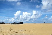 Kanaway beach in Jomalig
 A beach in southeastern Jomalig
 Lingayen Cove in Jomalig
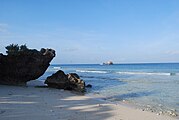 A beach in Balesin
 Themed accommodations at the Balesin Island Club
 Resort grounds in Balesin


References
- "Total Population by Province, City, Municipality and Barangay: as of May 1, 2010" (PDF). 2010 Census of Population and Housing. National Statistics Office. Archived from the original (PDF) on 29 October 2013. Retrieved 27 November 2013.
- "The Ultimate Travel Guide to Polillo Group of Islands". Polillo Travelers. Retrieved 15 November 2020.
- "Polillo Islands". BirdLife International. Retrieved 15 November 2020.
External links
 Polillo Islands travel guide from Wikivoyage
Places adjacent to Polillo Islands | ||||||||||||||||
|---|---|---|---|---|---|---|---|---|---|---|---|---|---|---|---|---|
| ||||||||||||||||
Lucena (capital) | |
| Municipalities |
|
| Component city | |
| Highly urbanized city |
|
Authority control | |
|---|---|
| General |
|
| National libraries | |
На других языках
[de] Polillo-Archipel
Der Polillo-Archipel (en: Polillo Islands) ist eine Inselgruppe in den Philippinen. Die Gruppe von über 30 Inseln liegt in der Philippinensee, ca. 25 km östlich der Insel Luzon, getrennt von ihr durch die Straße von Polillo. Der Archipel bildet die nördliche Grenze der Bucht von Lamon.- [en] Polillo Islands
Другой контент может иметь иную лицензию. Перед использованием материалов сайта WikiSort.org внимательно изучите правила лицензирования конкретных элементов наполнения сайта.
WikiSort.org - проект по пересортировке и дополнению контента Википедии