geo.wikisort.org - Island
Pléneau Island (65°6′S 64°3′W) is an island, 0.8 nautical miles (1.5 km) long, lying just northeast of Hovgaard Island in the Wilhelm Archipelago. Charted as a peninsula of Hovgaard Island by the French Antarctic Expedition, 1903–05, under J.B. Charcot, who named its northeast point for Paul Pléneau, photographer of the expedition. The feature was first shown to be an island on an Argentine government chart of 1957.
 Kayakers around Pléneau Island
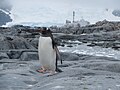 Gentoo penguin on Pléneau Island
 Gentoo penguin and chicks on Pléneau Island
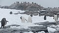 Gentoo penguin colony on Pléneau Island
 Scientist counts Gentoo penguins on Pléneau Island
 Pléneau Island


See also
- List of Antarctic and sub-Antarctic islands
References
![]() This article incorporates public domain material from the United States Geological Survey document: "Pléneau Island". (content from the Geographic Names Information System)
This article incorporates public domain material from the United States Geological Survey document: "Pléneau Island". (content from the Geographic Names Information System)
Further reading
This Wilhelm Archipelago location article is a stub. You can help Wikipedia by expanding it. |
На других языках
[de] Pléneau-Insel
Die Pléneau-Insel ist eine 1,3 km lange Insel im Wilhelm-Archipel vor der Westküste des Grahamlands im Norden der Antarktischen Halbinsel. Sie liegt unmittelbar nordöstlich der Krogmanninsel.- [en] Pléneau Island
[fr] Île Pléneau
L’île Pléneau est une île de 1,5 km de long, située au sud-ouest de l’île Booth dans l’archipel Wilhelm au large de la péninsule Antarctique. Découverte par la première expédition française en Antarctique conduite par Jean-Baptiste Charcot, qui s’est déroulée du 31 août 1903 au 4 mars 1905, celui-ci l’a nommé en l’honneur de Paul Pléneau, photographe de l’expédition.Текст в блоке "Читать" взят с сайта "Википедия" и доступен по лицензии Creative Commons Attribution-ShareAlike; в отдельных случаях могут действовать дополнительные условия.
Другой контент может иметь иную лицензию. Перед использованием материалов сайта WikiSort.org внимательно изучите правила лицензирования конкретных элементов наполнения сайта.
Другой контент может иметь иную лицензию. Перед использованием материалов сайта WikiSort.org внимательно изучите правила лицензирования конкретных элементов наполнения сайта.
2019-2025
WikiSort.org - проект по пересортировке и дополнению контента Википедии
WikiSort.org - проект по пересортировке и дополнению контента Википедии