geo.wikisort.org - Island
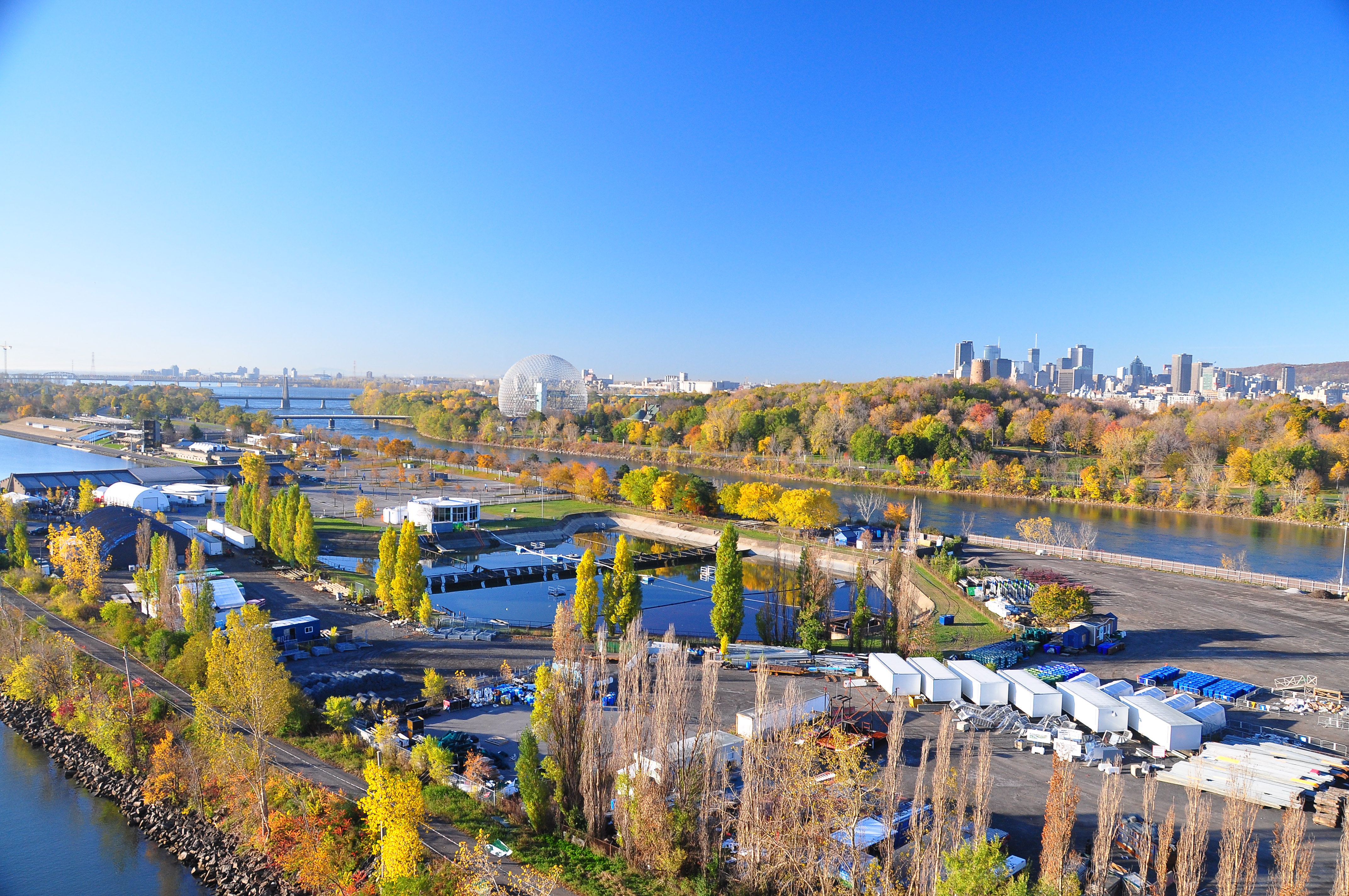
Notre Dame Island (French: Île Notre-Dame) is an artificial island in the Saint Lawrence River in Montreal, Quebec, Canada. It is immediately to the east of Saint Helen's Island and west of the Saint Lawrence Seaway and the city of Saint-Lambert on the south shore. Together with Saint Helen's Island, it makes up Parc Jean-Drapeau, which forms part of the Hochelaga Archipelago. To the southeast, the island is connected to the embankment separating the seaway and Lachine Rapids.
 | |
Notre-Dame Island Site by Montreal Island, in St. Lawrence River | |
| Geography | |
|---|---|
| Location | Saint Lawrence River |
| Coordinates | 45°30′15″N 73°31′35″W |
| Administration | |
| Province | |
| City | |
| Borough | Ville-Marie |
| Demographics | |
| Population | 0 |
Parc Jean-Drapeau is registered as a leg of the Route Verte and Trans Canada Trail.
It houses the Circuit Gilles Villeneuve, host of the Canadian Grand Prix of Formula One.
History
Notre Dame Island was built in ten months from 15 million tons of rock excavated for the Montreal Metro underground rail in 1965. It was created for Expo 67 to celebrate Canada's centennial.
Nearly all of the remaining Expo 67 pavilions were demolished in 1975 to make way for a long rowing and canoeing basin for Montreal's 1976 Summer Olympics. The Olympic Basin is still North America's largest artificial rowing basin. The former pavilion of France and the pavillon of Quebec was gutted, redecorated, and became the Montreal Casino, as a large gambling establishment owned and operated by the Government of Quebec. The Canadian Pavilion now serves the administration of the Société du parc Jean-Drapeau, a para-municipal body of the city of Montreal, manager of Parc Jean-Drapeau.
The park area on the island's southern tip has a small lake with a beach open throughout the summer for swimming, volleyball and watercraft rentals. During the decades since Expo 67, the city of Montreal has embellished the island with plants and trees, making it look less artificial.
In 1980 the greening and beautification of the island was accelerated when it was the host to the Floralies Internationales, a horticultural exhibition and competition gathering plant masterpieces from dozens of countries. Still accessible today from spring to autumn, these magnificent gardens cover over 25 hectares (62 acres). The Floralies gardens are preserved and arranged creatively by the Parc Jean-Drapeau team of gardeners. In addition, the micro-climate created in part by the lagoons crisscrossing the island promotes the uniqueness of these gardens by allowing plants usually intolerant of Montreal's cold climate to grow.
The park hosted the ICF Canoe Sprint World Championships in 1986.
Off-season
In fall and spring, visitors to Notre Dame Island primarily consist of gamblers at the casino and rowers and canoers at the Olympic Basin. During the coldest part of winter, ice skaters use the basin as a rink. City workers clear the snow from its icy surface as part of the annual winter festival, "La Fête des Neiges de Montréal". However, the ice rink was located on Saint Helen's Island, close to the Jean-Drapeau metro station, the past few years. Cross-country skiers and snowshoers can also tour the area.
Circuit Gilles Villeneuve
Each summer, Notre-Dame Island's Circuit Gilles Villeneuve hosts the Formula One Canadian Grand Prix race and used to host the NAPA Auto Parts 200 of NASCAR's Nationwide Series (now known as the Xfinity Series). The circuit, opened in 1978, is accessible to the public when it is not being used for motorsports.
Gallery
 Kwakiutl Totem pole
 The Olympic Basin in the winter
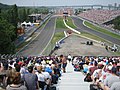
 The Montreal Casino
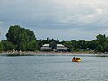 The beach during the summer
 La Maison d'Autrefois du Québec


See also
- Land reclamation
- List of islands of Quebec
References
- 1976 Summer Olympics official report. Volume 2. pp. 112–7.
- Gray, Jeremy. Montreal. Lonely Planet, 2004. p. 50 and 59.
- Frommer, Arthur. Montreal and Quebec City, 2007. p. 65.
- McKay, Emma ed. Montreal and Quebec City. Colour guide, 2005. p. 23.
- Ulysses Travel Guides. Collective (2007). Montreal. Montreal: ulyssesguides.com. Ulysses Travel Guides. ISBN 978-2-89464-797-4. pp. 189–190
External links
| Montreal Olympic Park |
|  |
|---|---|---|
| Greater Montreal | ||
| Football venues |
| |
| Handball venues | ||
| Other venues | ||
Olympic venues in canoeing | ||
|---|---|---|
| 20th century |
|  |
| 21st century |
| |
Olympic venues in rowing | ||
|---|---|---|
| 20th century |
|  |
| 21st century |
| |
Landmarks of Montreal | |
|---|---|
| Museums |
|
| Churches |
|
| Skyscrapers |
|
| Other structures |
|
| Nature and parks |
|
| Squares |
|
| Islands |
|
| Transportation |
|
| Events |
|
| Cemeteries |
|
| Establishments |
|
| Related |
|
| |
| Authority control |
|
|---|
На других языках
[de] Île Notre-Dame
Die Île Notre-Dame ist eine im Sankt-Lorenz-Strom gelegene künstliche Flussinsel in der kanadischen Provinz Québec. Sie entstand 1965 aus dem Aushub der Metro Montreal und war zwei Jahre später Teil des Ausstellungsgeländes der Expo 67. Zusammen mit der benachbarten Île Sainte-Hélène bildet sie den Parc Jean-Drapeau.- [en] Notre Dame Island
[es] Île Notre-Dame
La Isla de Nuestra Señora (en francés: Île Notre-Dame) es una isla artificial creada con la tierra proveniente de las excavaciones del metro de Montreal en 1965. Fue creada en ocasión de la Expo 67, que conmemoró el centenario de Canadá. La isla forma parte de la ciudad de Montreal, y se encuentra localizada en el río San Lorenzo, al sur de la Isla de Santa Elena. Junto con esta última, conforman el parque Jean-Drapeau, que es uno de los más grandes de la ciudad. El parque debe su nombre al alcalde Jean Drapeau, que fue el impulsor de la exposición mundial y de los Juegos Olímpicos en la ciudad.[fr] Île Notre-Dame
L'île Notre-Dame est une île artificielle de l'archipel d'Hochelaga qui forme le coeur du Grand-Montréal. Elle a été érigée en 10 mois en 1965. Le matériau de remblai provient initialement du dragage du fleuve Saint-Laurent, puis de sols déplacés lors de l'excavation du métro de Montréal (entre 15 et 20 %), ainsi que des carrières de la région[1]. Cette réalisation fut le plus grand chantier jamais réalisé au Québec sur une si brève période. Elle impliqua, entre autres, la construction de plus de 800 bâtiments et de 27 ponts ainsi que l'aménagement de 80 kilomètres de routes [2]. Elle fut créée pour l'Expo 67 pour souligner le centième anniversaire du Canada. Elle est située sur le fleuve Saint-Laurent, à l'est de l'île Sainte-Hélène, séparé par le chenal Le Moyne, et à l'ouest de la voie maritime du Saint-Laurent. Avec l'île Sainte-Hélène, elle forme le parc Jean-Drapeau, un des plus grands parcs de Montréal. Le parc a été nommé à l'honneur de l'ancien maire de Montréal, Jean Drapeau.[ru] Нотр-Дам (остров)
Нотр-Дам (фр. Île Notre-Dame) — искусственный остров, расположенный на реке Святого Лаврентия в Монреале, Квебек, Канада. Остров расположен к востоку от острова Святой Елены и к западу от морского пути Святого Лаврентия, на южном берегу острова расположен город Сен-Ламбер. Вместе с островом Сент-Элен Нотр-Дам составляет парк Жана Драпо, который является частью архипелага Ошлага. На юго-западе остров соединен с материком.Другой контент может иметь иную лицензию. Перед использованием материалов сайта WikiSort.org внимательно изучите правила лицензирования конкретных элементов наполнения сайта.
WikiSort.org - проект по пересортировке и дополнению контента Википедии