 Diocesan Center and San Jose Parish church located in the poblacion of Navotas
 Navotas Centennial Park in Barangay Bagumbayan South
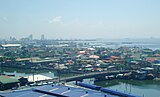 Aerial Shot of Navotas
geo.wikisort.org - Island
Navotas Island is an island in the city of Navotas, Metro Manila, Philippines. Situated in the Tullahan River delta, it is surrounded on the west by the Manila Bay, on the north by the Tangos River, on the east by the Navotas River, and on the south by the Tullahan River. The city center or poblacion of Navotas is located in the island. With an estimated land area of 1.95 km2, makes Navotas Island, one of the most densest islands in the world.
Isla ng Navotas | |
|---|---|
 | |
 Navotas Island Location within the Philippines | |
| Geography | |
| Coordinates | 14°39′49″N 120°56′35″E |
| Adjacent to | Manila Bay Tullahan River |
| Area | 1.95 km2 (0.75 sq mi) |
| Administration | |
| Region | National Capital Region |
| City | Navotas |
| Demographics | |
| Population | 117,196 (2020) |
| Pop. density | 60,100/km2 (155700/sq mi) |
| Ethnic groups | Tagalog |
Barangays
Nine out of the eighteen barangays of the city are located in the island. They are namely;
- Bagumbayan North
- Bagumbayan South
- Daanghari
- Navotas East
- Navotas West
- San Jose (Poblacion)
- San Roque
- Sipac-Almacen
- Tangos North
- Tangos South
Geography
The island is located at the mouth of the Tullahan River delta, in the northwest of Metro Manila. Bridges connect the island to the rest of city of Navotas in the south and to the city of Malabon in the east.
Demographics
The total population of Navotas Island is 117,196.
As of 2020, below is the total population of the barangays of Navotas Island.[1]
| Barangay | Population (2020) |
|---|---|
| Bagumbayan North | 1,677 |
| Bagumbayan South | 4,331 |
| Daanghari | 14,348 |
| Navotas East | 2,126 |
| Navotas West | 6,367 |
| San Jose (Pob.) | 23,950 |
| San Roque | 19,361 |
| Sipac-Almacen | 9,163 |
| Tangos North | 17,514 |
| Tangos South | 18,359 |
| Total | 117,196 |
Transport
There are jeepney routes going to Navotas from nearby cities, Malabon, Caloocan and Manila. Also, direct bus lines to Navotas from several cities in Mega Manila, such as Parañaque, Taguig, Muntinlupa, Makati, Dasmariñas, Cavite and San Pedro, Laguna.
Boat trips are also available from Malabon and Barangay Tanza to Navotas.
Gallery


See also
References
- "City of Navotas - Philippine Standard Geographic Code". Philippine Statistics Authority. Retrieved 2022-06-30.
This article about a location in the Philippines is a stub. You can help Wikipedia by expanding it. |
Текст в блоке "Читать" взят с сайта "Википедия" и доступен по лицензии Creative Commons Attribution-ShareAlike; в отдельных случаях могут действовать дополнительные условия.
Другой контент может иметь иную лицензию. Перед использованием материалов сайта WikiSort.org внимательно изучите правила лицензирования конкретных элементов наполнения сайта.
Другой контент может иметь иную лицензию. Перед использованием материалов сайта WikiSort.org внимательно изучите правила лицензирования конкретных элементов наполнения сайта.
2019-2026
WikiSort.org - проект по пересортировке и дополнению контента Википедии
WikiSort.org - проект по пересортировке и дополнению контента Википедии