geo.wikisort.org - Island
Namonuito Atoll, also called Namonweito, Weito, or Magur Islands, is the largest atoll of the Federated States of Micronesia and of the Caroline Islands with a total area of 2,267 square kilometres (875 square miles), unless one considers the still larger Chuuk (Truk) Lagoon as a type of atoll in an early stage of development. In Micronesia, only Kwajalein Atoll of the Marshall Islands is still larger.

Namonuito Atoll lies in the northwestern region (Oksoritod) of Chuuk State, the largest federal state of the Federated States of Micronesia, about 170 kilometres (110 miles) northwest of Chuuk Lagoon (measured from Pisaras Islet to the northern and western parts of the fringing reef of Chuuk Lagoon. It is roughly triangular in shape, with the base running 82 kilometres (51 miles) along its southern side.
The southwest corner of the triangle is marked by Ulul islet, the main island (largest and most populated), also called Onoun.
The other islets lie mostly on the northeast side, from Pisaras islet in the southeast corner to Magur (Makur) islet in the north corner. The 12 islets have an aggregate land area of only 4.5 square kilometres (1.7 square miles). The total population is 1,341 (census of 2000).
The reef rim of the atoll is submerged for the greater part and is marked by the lighter colour of the water over it. The depths on the reef range from 0.9 to 18.3 metres (2 feet 11.4 inches to 60 feet 0.5 inches). The reef appears to be in the process of formation and can be crossed at many places. The lagoon is not of uniform depth. Except for a 5.5 metres (18.0 feet) patch, located 22 kilometres (14 miles) west of Pisaras island, and a detached reef, with depths of 2.7 to 3.7 metres (8 feet 10 inches to 12 feet 2 inches), located about 10 kilometres (6.2 miles) of Pisaras, there appears to be a depth greater than 9 metres (30 feet) on the scattered lagoon coral heads.
Pisaras Island has coconut palms and other trees growing on it. Reefs extend northwest and west-northwest from the island, enclosing a shallow and foul bay. Ulul Island is densely covered with coconut palms. A drying reef fringes the island. There is a radio station on the island.
The atoll is home to five of the 40 municipalities of Chuuk state, listed in counterclockwise sequence, with population (2000):
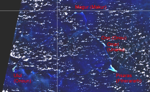 Landsat visible color image | ||||||||
| Municipality | alternate or former name |
Land area km² |
Population (census 2000) |
location | islands | coordinates | ||
|---|---|---|---|---|---|---|---|---|
| Onoun | Ulul | 2.54 | 598 | southwest corner | Ulul Island | 08°35′22″N 149°39′37″E | ||
| Piherararh |
Pisaras |
0.80 |
227 |
southeast corner |
Wabonoru Islet Pisaras Island Pielimal Islet Weltot Islet |
08°35′50″N 150°21′18″E 08°34′55″N 150°24′26″E 08°36′50″N 150°22′38″E 08°37′15″N 150°22′16″E | ||
| Unanu |
Onari |
0.26 |
178 |
northeast rim |
Onari Island Bihof Islet Behiliper Islet Amurtride Islet |
08°45′11″N 150°19′46″E 08°45′43″N 150°19′24″E 08°46′03″N 150°19′02″E 08°46′10″N 150°18′47″E | ||
| Onou | Ono | 0.31 | 182 | northeast rim | Ono Island | 08°47′52″N 150°16′58″E | ||
| Makur |
Magur Islands |
0.47 |
156 |
north corner |
Magur Island Magererik Islet |
08°59′27″N 150°07′22″E 08°57′24″N 150°03′53″E | ||
| Namonuito Atoll | Magur Islands | 4.38 | 1,341 | 08°40′00″N 150°00′00″E | ||||
History
Namonuito was first visited by Spanish explorers on the galleon San Jerónimo on 5 July 1566. At Pisaras Island, the rebel pilot Lope Martín and his gang of mutineers (thirteen soldiers and thirteen sailors) murdered Captain Pero Sánchez Pericón and other expedition members, and were subsequently marooned.[1][2]
Onou Island was later visited by Spanish naval officer Juan Antonio de Ibargoitia commanding the vessel Filipino in 1801 who charted it as Anonima (Anonymous).[3]
Onoun Airfield
Onoun Airfield | |||||||||||
|---|---|---|---|---|---|---|---|---|---|---|---|
| |||||||||||
| Summary | |||||||||||
| Airport type | Public | ||||||||||
| Owner | Government | ||||||||||
| Operator | Civil Government | ||||||||||
| Serves | Namonuito Atoll | ||||||||||
| Runways | |||||||||||
| |||||||||||
Onoun Airfield is located on the west side of the atoll. Caroline Islands Air has chartered service. Aircraft land on a 1,200 feet (370 m) chipseal runway.[4]
References
- Coello, Francisco La Conferencia de Berlín y la cuestión de las Carolinas: Discursos pronunciados en la Sociedad Geográfica de Madrid, Madrid, Imprenta de Fortanet, 1885, p.96
- Krämer, Augustin Ergebnisse der Südsee Expedition, Friederichsen, De Gruyter, 1908,p.197-198
- Sharp, Andrew The discovery of the Pacific Islands, Clarendon Press, Oxford, 1960, p.183
- "Federated States of Micronesia (FSM) Division of Civil Aviation | Onoun (Ulul) Civil Airfield, Namonuito Atoll, Micronesia".
External links
- Sailing Directions (enroute), page 263
- exact islet coordinates
- historic census data, population densities
- about Juan Antonio de Ibargoitia
| Authority control |
|
|---|
На других языках
[de] Namonuito
Namonuito, auch Namonweito, Weito, oder Magur Islands, ist ein großes Atoll im Nordwesten des Staates Chuuk der Föderierten Staaten von Mikronesien.- [en] Namonuito Atoll
[fr] Namonuito
Namonuito (également connu comme Namonweito, Weito ou îles Magur) est le plus grand atoll des États fédérés de Micronésie et des îles Carolines, avec une superficie totale de 2 267 km², à moins qu'on considère que le lagon plus grand de Truk comme un type d'atoll au premier temps de son développement. En Micronésie, seul Kwajalein des îles Marshall est plus grand.[it] Namonuito
Namonuito, chiamato anche Namonweito, Weito, o Isola Magur, è il più grande atollo degli Stati Federati di Micronesia nelle Isole Caroline, con un'area totale (isolette e laguna) di 2.267 km², senza considerare l'ancora più grande Laguna Truk è un tipo di atollo in forte stato di corrosione. In Micronesia, soltanto l'atollo Kwajalein delle Isole Marshall è così vasto.Другой контент может иметь иную лицензию. Перед использованием материалов сайта WikiSort.org внимательно изучите правила лицензирования конкретных элементов наполнения сайта.
WikiSort.org - проект по пересортировке и дополнению контента Википедии