geo.wikisort.org - Island
Middle Andaman Island is an island of the Andaman Islands. It belongs to the North and Middle Andaman administrative district, part of the Indian union territory of Andaman and Nicobar Islands.[6]
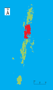 Outline map of the Andaman Islands, with the location of Middle Andaman Island highlighted (in red). | |
 Middle Andaman Island Location within the territory of the Andaman and Nicobar Islands, and within the Bay of Bengal  Middle Andaman Island Middle Andaman Island (Bay of Bengal) | |
| Geography | |
|---|---|
| Location | Bay of Bengal |
| Coordinates | 12.5°N 92.833333°E |
| Archipelago | Andaman Islands |
| Adjacent to | Indian Ocean |
| Total islands | 1 |
| Major islands |
|
| Area | 1,523 km2 (588 sq mi)[1] |
| Length | 70 km (43 mi) |
| Width | 28 km (17.4 mi) |
| Coastline | 272 km (169 mi) |
| Highest elevation | 512 m (1680 ft)[2] |
| Highest point | Mount Diavolo |
| Administration | |
| District | North and Middle Andaman |
| Island group | Andaman Islands |
| Island sub-group | Great Andaman |
| Taluk | Multiple |
| Largest settlement | Rangat Metropolitan (pop 10,000) |
| Demographics | |
| Population | 55,632 (2011)Only middle andaman villages from the 2011 census |
| Pop. density | 36.5/km2 (94.5/sq mi) |
| Ethnic groups | Hindu, Andamanese, Jarawa |
| Additional information | |
| Time zone |
|
| PIN | 744202[3] |
| Telephone code | 031927[4] |
| ISO code | IN-AN-00[5] |
| Official website | www |
| Literacy | 84.4% |
| Avg. summer temperature | 30.2 °C (86.4 °F) |
| Avg. winter temperature | 23.0 °C (73.4 °F) |
| Sex ratio | 1.2♂/♀ |
| Census Code | 35.639.0004 |
| Official Languages | Hindi, English |
Geography
The island belongs to the Great Andaman Chain and is located 73 km (45 mi) north from Port Blair. It is the central island of the Great Andaman archipelago of India, with a total area of 1,536 km². Middle Andaman is separated from North Andaman Island by Austen Strait, and from Baratang Island at the south by Homfray's Strait, both shallow and narrow channels, a few hundred metres wide; and from Interview Island at its west by the navigable Interview Passage.[7]
The island's coastline was inundated by the tsunami resulting from the 26 December 2004 Indian Ocean earthquake, though the effect was far less severe when compared with other Islands of Andaman and Nicobar Islands.
Administration
Politically, Middle Andaman Island, is part of Mayabunder and Rangat Tehsils.[8] [9][10]
Demographics
Population of Middle Andaman consists of Bengali, Tamil and Keralite settlers. The island is also home to many of the indigenous Jarawa people. The main occupation of the inhabitants is farming and Agriculture.
Middle Andaman's main towns (Metro population in brackets) are Rangat (10,000), Mayabunder (5,565), Bakultala (4,454), Nimbutala (3,063), and Kadamtala (3,008).
According to the 2011 census of India, the Island has x households. The effective literacy rate (i.e. the literacy rate of population excluding children aged 6 and below) is 76%.[11]
| Total | Male | Female | |
|---|---|---|---|
| Population | 55632 | 28767 | 26865 |
| Children aged below 6 years | 2065 | 1039 | 1026 |
| Scheduled caste | 0 | 0 | 0 |
| Scheduled tribe | 3 | 3 | 3 |
| Literates | 42294 | 22946 | 19348 |
| Workers (all) | 2 | 2 | 0 |
| Main workers (total) | 2 | 2 | 0 |
Tourism
The island hosts immaculate waterfalls, and pretty beaches. Adventurous fun such as Island camping, trekking, Scuba diving, snorkeling, and other exciting water sports offer you chance to indulge in real pleasure.[12]
References
- "Islandwise Area and Population - 2011 Census" (PDF). Government of Andaman. Archived from the original (PDF) on 28 August 2017. Retrieved 28 September 2016.
- Sailing Directions (Enroute), Pub. 173: India and the Bay of Bengal (PDF). Sailing Directions. United States National Geospatial-Intelligence Agency. 2017. p. 281.
- "A&N Islands - Pincodes". 22 September 2016. Archived from the original on 23 March 2014. Retrieved 22 September 2016.
{{cite web}}: CS1 maint: bot: original URL status unknown (link) - "STD Codes of Andaman and Nicobar". allcodesindia.in. Retrieved 23 September 2016.
- Registration Plate Numbers added to ISO Code
- "Village Code Directory: Andaman & Nicobar Islands" (PDF). Census of India. Retrieved 16 January 2011.
- Edgar Thorpe, Showick Thorpe (2011) The Pearson CSAT Manual 2011. Accessed on 2012-07-26
- "DEMOGRAPHIC – A&N ISLANDS" (PDF). andssw1.and.nic.in. Archived from the original (PDF) on 28 August 2017. Retrieved 23 September 2016.
- "north part map". Archived from the original on 10 May 2017. Retrieved 17 October 2016.
- "south part map". Archived from the original on 10 May 2017. Retrieved 17 October 2016.
- "District Census Handbook - Andaman & Nicobar Islands" (PDF). 2011 Census of India. Directorate of Census Operations, Andaman & Nicobar Islands. Archived from the original (PDF) on 1 August 2015. Retrieved 21 July 2015.
- "Rangat Island in Andaman and Nicobar, Information of Rangat Island in Andaman". www.indiatravelnext.com. Archived from the original on 20 May 2013. Retrieved 13 January 2022.
- Geological Survey of India
 Andaman and Nicobar Islands travel guide from Wikivoyage
- Middle Andaman Island travel guide from Wikivoyage
На других языках
[de] Middle Andaman Island
Mittel-Andaman oder englisch Middle Andaman Island ist die größte der drei Hauptinseln der Andamanen im Indischen Ozean. Politisch gehört die Insel zum indischen Unionsterritorium Andamanen und Nikobaren.- [en] Middle Andaman Island
[fr] Andaman du centre
Andaman du centre est une île de l'archipel de Grande Andaman, en Inde, d'une superficie de 1 536 km2. La population est constituée de Bengalais, Tamouls et Kéralites. L'activité de l'île est essentiellement agricole.[it] Andaman Centrale
Andaman Centrale o Isola Andamana Centrale (Middle Andaman in inglese) è una delle 3 principali isole dell'arcipelago delle Isole Andamane in India.[ru] Средний Андаман
Средний Андаман (англ. Middle Andaman Island) — центральный остров архипелага Большой Андаман площадью в 1535,5 км². Население острова в 2001 году — 54 385 человек[1] и состоит из переселенцев из Бенгалии, Тамилнада и Кералы. На острове также проживает много людей, относящихся к народности джарава. Основное занятие жителей острова — сельское хозяйство.Другой контент может иметь иную лицензию. Перед использованием материалов сайта WikiSort.org внимательно изучите правила лицензирования конкретных элементов наполнения сайта.
WikiSort.org - проект по пересортировке и дополнению контента Википедии