geo.wikisort.org - Island
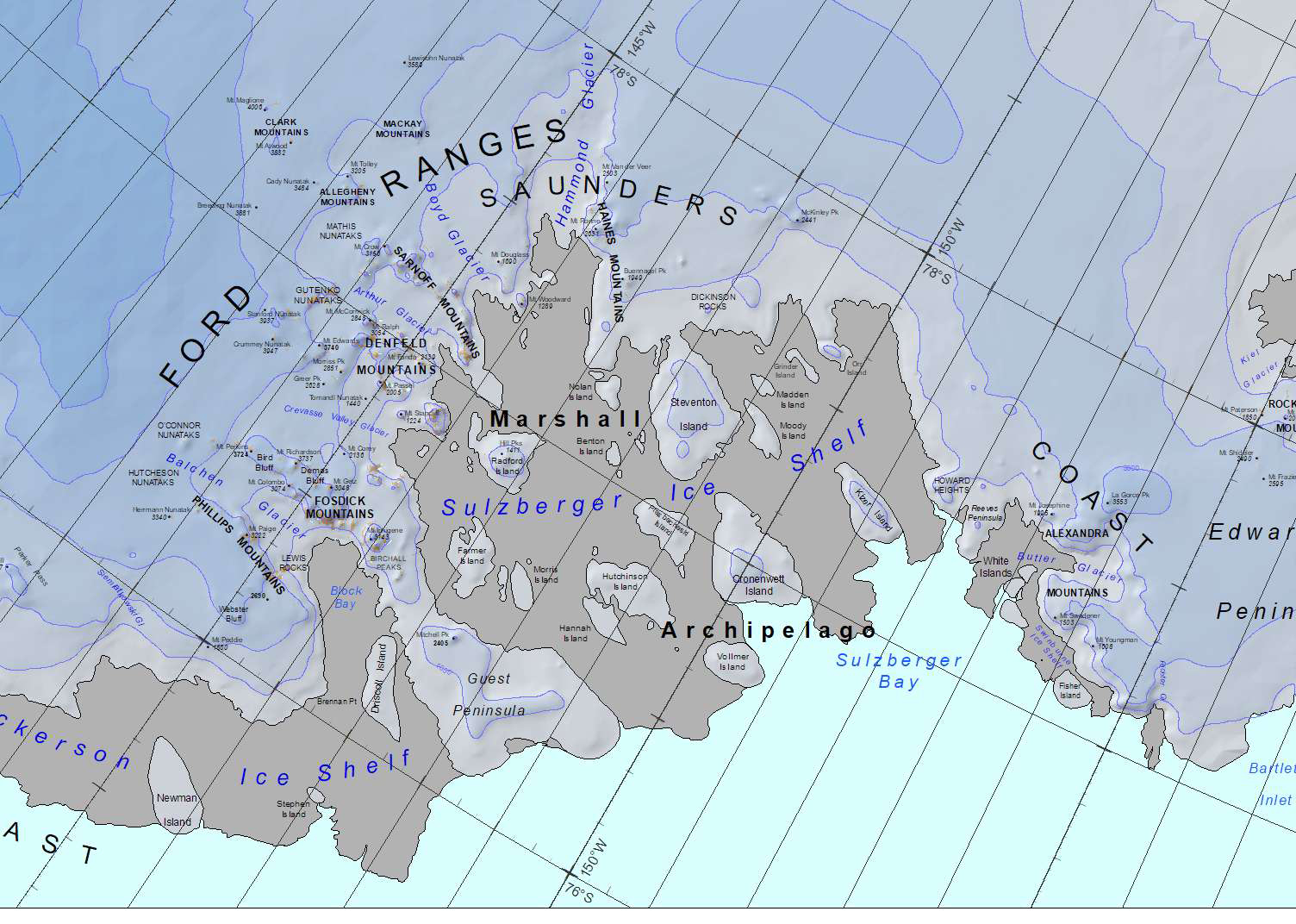
The Marshall Archipelago is an extensive group of large ice-covered islands within the Sulzberger Ice Shelf off Antarctica. Several of the islands were discovered and plotted by the Byrd Antarctic Expeditions (1928–30 and 1933–35) and by the United States Antarctic Service (1939–41), all led by Admiral Richard E. Byrd. The full extent of the archipelago was mapped by the United States Geological Survey from surveys and U.S. Navy air photos (1959–65). The name was proposed by Admiral Byrd for General of the Army George C. Marshall, who made financial contributions as a private individual and also, on the same basis, provided advisory assistance to the Byrd expedition of 1933–35.[1]
 Map of the Marshall Archipelago | |
 Marshall Archipelago Location in Antarctica | |
| Geography | |
|---|---|
| Location | Marie Byrd Land, Antarctica |
| Coordinates | 77°0′S 148°30′W |
| Total islands | 10 |
| Administration | |
| Administered under the Antarctic Treaty System | |
| Demographics | |
| Population | Uninhabited |
Islands
- Benton Island (77°4′S 147°53′W) is an island 7.4 kilometres (4 nmi) in length, lying northwest of Nolan Island and 9.3 kilometres (5 nmi) west of Przybyszewski Island in the Marshall Archipelago.
- Cronenwett Island (77°0′S 150°0′W) is an island 37 kilometres (20 nmi) in length making it the longest island in the archipelago. The island lies between Vollmer Island and Steventon Island in the Marshall Archipelago. Although the island is near Vollmer Island, Vollmer Island is not actually considered one of the islands of the Marshall Archipelago.
- Grinder Island (77°34′S 149°20′W) is an island 13 kilometres (7 nmi) in length and 1.9 kilometres (1 nmi) in width. The island lies 24 kilometres (13 nmi) southwest of Steventon Island within the Marshall Archipelago.
- Hannah Island (76°39′S 148°48′W) is an island lying between Hutchinson Island and Guest Peninsula lying within the Marshall Archipelago.
- Hutchinson Island (76°47′S 148°53′W) is an island 28 kilometres (15 nmi) long, lying 19 kilometres (10 nmi) east of Vollmer Island.
- Kramer Island (77°14′S 147°10′W) is an island 3.7 kilometres (2 nmi) in length and is situated between Nolan Island and Court Ridge in the Marshall Archipelago.
- Madden Island (77°27′S 149°3′W) is an island 7.4 kilometres (4 nmi) in length and is located between Moody Island and Grinder Island in the Marshall Archipelago.
- Orr Island (77°38′S 149°36′W) is an island 5 nautical miles (9.3 km; 5.8 mi) in length and lies 5.6 kilometres (3 nmi) southwest of Grinder Island in the Marshall Archipelago.
- Przybyszewski Island (76°58′S 148°45′W) is an island 22 kilometres (12 nmi) in length and lies 5.6 kilometres (3 nmi) east of Cronenwett Island in the Marshall Archipelago. Barela Rock appears to be a rock formation of interest, located in the southern portion of Przybyszewski Island.
- Thode Island (77°2′S 148°3′W) is an island 1.9 kilometres (1 nmi) northwest of Benton Island and 9.3 kilometres (5 nmi) east of Przybyszewski Island in the Marshall Archipelago.
References
- "Marshall Archipelago". Geographic Names Information System. United States Geological Survey. Retrieved 2013-08-14.
![]() This article incorporates public domain material from the United States Geological Survey document: "Marshall Archipelago". (content from the Geographic Names Information System)
This article incorporates public domain material from the United States Geological Survey document: "Marshall Archipelago". (content from the Geographic Names Information System)
This Marie Byrd Land location article is a stub. You can help Wikipedia by expanding it. |
На других языках
[de] Marshall-Archipel
Der Marshall-Archipel umfasst eine weitläufige Gruppe großer, eisbedeckter Inseln inmitten des Sulzberger-Schelfeises vor der Saunders-Küste des westantarktischen Marie-Byrd-Landes.- [en] Marshall Archipelago
[it] Arcipelago Marshall
L'arcipelago Marshall è un gruppo di diverse isole rocciose e completamente ricoperte dai ghiacci situate all'interno della baia di Sulzberger, davanti alla costa di Saunders, nella Terra di Marie Byrd, in Antartide. A parte le più occidentali, che sono in parte bagnate dal mare, le isole dell'arcipelago, che sono racchiuse tra la penisola Guest, a nord, e la penisola di Edoardo VII, a sud, sono completamente circondate dai ghiacci che compongono la piattaforma glaciale Sulzberger.[1]Другой контент может иметь иную лицензию. Перед использованием материалов сайта WikiSort.org внимательно изучите правила лицензирования конкретных элементов наполнения сайта.
WikiSort.org - проект по пересортировке и дополнению контента Википедии