geo.wikisort.org - Island
This is a list of islands of Kuwait. Kuwait has ten islands (including one former island). They are indicated on the NASA satellite image and listed in the table in order from north to south:
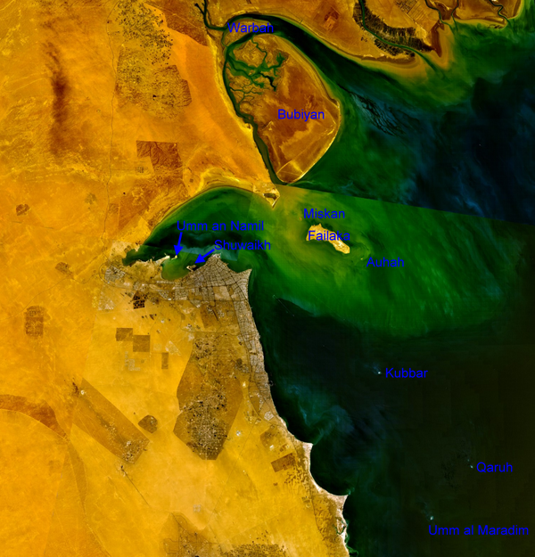 | ||||||||
| NASA Visible Color Satellite Image with islands of Kuwait | ||||||||
| Island | Arabic | Area km² | Coordinates | |||||
|---|---|---|---|---|---|---|---|---|
| northern islands (Al Jahra Governorate) | ||||||||
| Warbah Island | جَزِيرَة وَرْبَة | 37 | 29°59′38″N 48°04′00″E | |||||
| Bubiyan Island | جَزِيرَة بُوبِيَان | 863 | 29°44′41″N 48°21′03″E | |||||
| Failaka with satellite islands (Al Asimah Governorate) | ||||||||
| Miskan Island | جَزِيرَة مِسْكَان | 0.75 | 29°29′05″N 48°15′05″E | |||||
| Failaka Island | جَزِيرَة فَيْلَكَا | 20 | 29°26′26″N 48°20′05″E | |||||
| Auhah Island | جَزِيرَة عَوْهَة | 0.35 | 29°22′40″N 48°26′21″E | |||||
| islands of Kuwait Bay (Al Asimah Governorate) | ||||||||
| Umm an Namil Island | جَزِيرَة أُمّ اَلنَّمْل | 0.569 | 29°22′54″N 47°52′01″E | |||||
| Shuwaikh Island1) | جَزِيرَة قُرَيْن | 0.012 | 29°21′16″N 47°54′35″E | |||||
| southern islands (Al Ahmadi Governorate) | ||||||||
| Kubbar Island | جَزِيرَة كُبَّر | 0.11 | 29°04′20″N 48°29′36″E | |||||
| Qaruh Island | جَزِيرَة قَارُوه | 0.035 | 28°49′03″N 48°46′35″E | |||||
| Umm al Maradim Island | جَزِيرَة أُمّ اَلْمَرَادِم | 0.165 | 28°40′42″N 48°39′10″E | |||||
| Islands of Kuwait | 922 | |||||||
| 1) former island | ||||||||
See also
- Geography of Kuwait
- List of islands
External links
List of islands of Asia | |
|---|---|
| Sovereign states |
|
| States with limited recognition |
|
| Dependencies and other territories |
|
| |
| Authority control: National libraries |
|---|
На других языках
- [en] List of islands of Kuwait
[fr] Liste des îles du Koweït
Voici une liste des îles du Koweït.Текст в блоке "Читать" взят с сайта "Википедия" и доступен по лицензии Creative Commons Attribution-ShareAlike; в отдельных случаях могут действовать дополнительные условия.
Другой контент может иметь иную лицензию. Перед использованием материалов сайта WikiSort.org внимательно изучите правила лицензирования конкретных элементов наполнения сайта.
Другой контент может иметь иную лицензию. Перед использованием материалов сайта WikiSort.org внимательно изучите правила лицензирования конкретных элементов наполнения сайта.
2019-2025
WikiSort.org - проект по пересортировке и дополнению контента Википедии
WikiSort.org - проект по пересортировке и дополнению контента Википедии