geo.wikisort.org - Island
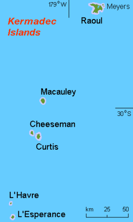
L'Esperance Rock, formerly known as French Rock and Brind Rock,[1](named after William Brind) is the southernmost islet in the Kermadec Islands, to the north of New Zealand. It is 80 km (50 mi) south of Curtis Island and 600 km (370 mi) northeast of East Cape on New Zealand's North Island. The smaller L'Havre Rock lies 8 km (5 mi) to the north-west of L'Esperance; it is a reef that barely reaches the surface. L'Esperance Rock is 250 m (820 ft) in diameter with an area of 4.8 ha (12 acres). It rises to a height of 70 m (230 ft).
 The rock from northeast | |
 L'Esperance Rock in the south of the Kermadec Islands | |
| Geography | |
|---|---|
| Coordinates | 31°26′S 178°54′W |
| Archipelago | Kermadec Islands |
| Area | 4.8 ha (12 acres) |
| Highest elevation | 70 m (230 ft) |
| Administration | |
New Zealand | |
| Demographics | |
| Population | 0 |
Important Bird Area
The island forms part of the Kermadec Islands Important Bird Area, identified as such by BirdLife International because it is an important site for nesting seabirds.[2] It is the site of a substantial breeding colony of grey noddies. Masked boobies have also been recorded breeding there.[3]
Flora
As well as other plants, there is an endemic conifer on the rock, Senecio esperensis.[4]
See also
- 2012 Kermadec Islands eruption and pumice raft
- New Zealand outlying islands
- List of islands of New Zealand
- List of islands
- Desert island
References
- Taonga, New Zealand Ministry for Culture and Heritage Te Manatu. "Brind, William Darby". www.teara.govt.nz.
- BirdLife International. (2012). Important Bird Areas factsheet: Kermadec Islands. Downloaded from http://www.birdlife.org on 2012-02-03.
- Greene et al. (2004).
- PJ de Lange, CS Liew, JR Rolfe & PB Pelser (2015). "Senecio esperensis (Asteraceae: Senecioneae)—a new combination for the L'Esperance Rock groundsel, Kermadec Islands". New Zealand Journal of Botany. 53 (3): 131–138. doi:10.1080/0028825X.2015.1039552.
{{cite journal}}: CS1 maint: multiple names: authors list (link)
- Greene, T.C.; Scofield, R.P.; Dilks, P.J. (July 2004). Status of Kermadec red-crowned parakeets and the likely effects of a proposed kiore eradication programme. Macauley Island expedition July 2002 (PDF). DOC Science Internal Series 179. Wellington: Department of Conservation, New Zealand. ISBN 0-478-22579-2.
Kermadec Islands | ||
|---|---|---|
| Islands | ||
| Seamounts | ||
This article about the geography of New Zealand's outlying islands is a stub. You can help Wikipedia by expanding it. |
На других языках
[de] L’Esperance Rock
L’Esperance Rock ist eine kleine, unbewohnte Insel vulkanischen Ursprungs im südwestlichen Pazifischen Ozean. Es ist die südlichste Insel der von Neuseeland verwalteten Kermadecinseln und liegt rund 80 km südsüdwestlich von Curtis Island. Vom East Cape auf der Nordinsel Neuseelands liegt sie gut 600 km entfernt.- [en] L'Esperance Rock
[fr] Île de l'Espérance
L'Île de l'Espérance (en anglais : Esperance Rock, soit « rocher de l'Espérance », autrefois French Rock, le « rocher français »), est la plus méridionale des Îles Kermadec, situées au Nord de l'Île du Nord de la Nouvelle-Zélande. Elle est à 80 km au Sud de île Curtis et à 600 km au Nord-Est de East Cape (en). Le petit îlot nommé "Havre Rock" se trouve à 8 km au nord-ouest de l'île de L'Espérance et c'est un récif qui atteint à peine la surface de l'eau. L'île d'"Esperance Rock" au contraire a 250 m de diamètre avec une surface de 4,8 ha et elle s'élève à 70 m de hauteur.Другой контент может иметь иную лицензию. Перед использованием материалов сайта WikiSort.org внимательно изучите правила лицензирования конкретных элементов наполнения сайта.
WikiSort.org - проект по пересортировке и дополнению контента Википедии