geo.wikisort.org - Island
Kukup Island (Malay: Pulau Kukup) is an island in Pontian District, Johor, Malaysia.
Native name: Kukup Pulau | |
|---|---|
 | |
 Kukup Island Location in Johor  Kukup Island Location in Malaysia | |
| Geography | |
| Location | Southeast Asia |
| Coordinates | 1°19′16.0″N 103°25′37.9″E |
| Archipelago | Malay Archipelago |
| Adjacent bodies of water | Strait of Malacca |
| Area | 6.472 km2 (2.499 sq mi) |
| Administration | |
| State | Johor |
| District | Pontian District |
| Designations | |
|---|---|
Ramsar Wetland | |
| Official name | Pulau Kukup |
| Designated | 31 January 2003 |
| Reference no. | 1287[1] |
Geology
The island is predominantly covered by mangrove and mudflat. It is surrounded by 8 km2 of mudflat. Recently (2018) it was rumored that the island holds large deposits of gold.
Geography
The island is located around 1 km offshore from Johor mainland. The island spans over an area of 6.472 km2.
Ecology
The island consists of various wildlife animals, such as monkeys, wild boars, mudskippers etc.[2][3]
 Amphibious fish
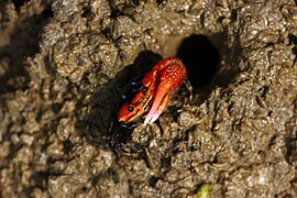 Fidler crab
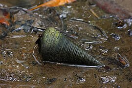 Telescopium telescopium
 Monkeys
 Mangrove forest


History
Kukup Island status as a remote hinterland changed in the 1990s when scientists began focusing on the island's biodiversity a unique ecological characteristics. In the interest of preserving this unique habitat, Kukup Island was gazetted a national park on 27 March 1997 under the Johor State Park Corporation Enactment 1989. On 31 January 2003, this island was granted the status of a "Wetland of International Importance", or Ramsar site, by the Geneva-based Ramsar Convention Bureau.[4][5]
See also
- List of islands of Malaysia
- List of Ramsar wetlands of international importance
References
- "Pulau Kukup". Ramsar Sites Information Service. Retrieved 25 April 2018.
- "Kukup Island National Park, Johor, Malaysia". Johor.attractionsinmalaysia.com. Retrieved 18 August 2018.
- "Kukup Island National Park—Kukup Resort". Kukupresort.com. Retrieved 18 August 2018.
- "How To Go To Kukup From Singapore (Kukup Travel Guide)". Taxi Singapore to Johor Bahru (JB) Malaysia | SGMYTAXI.com. 2 July 2016. Retrieved 31 October 2017.
- Admin. "Johorparks—Pulau Kukup". Johorparks.gov.my. Archived from the original on 2 August 2018. Retrieved 18 August 2018.
External links
This Johor location article is a stub. You can help Wikipedia by expanding it. |
Другой контент может иметь иную лицензию. Перед использованием материалов сайта WikiSort.org внимательно изучите правила лицензирования конкретных элементов наполнения сайта.
WikiSort.org - проект по пересортировке и дополнению контента Википедии