geo.wikisort.org - Island
Kaffeklubben Island or Coffee Club Island (Danish: Kaffeklubben Ø; Greenlandic: Inuit Qeqertaat) is an uninhabited island lying off the northern tip of Greenland. It contains the northernmost undisputed point of land on Earth.
Native name: Inuit Qeqertaat | |
|---|---|
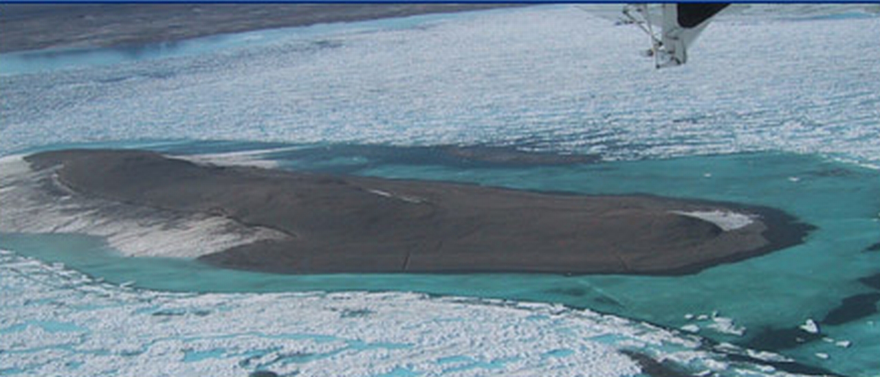 Aerial photograph of Kaffeklubben Island taken on September 29, 2008 | |
 Kaffeklubben Island | |
| Geography | |
| Location | Greenland |
| Coordinates | 83°39′45″N 30°36′50″W |
| Administration | |
Denmark | |
| Northeast Greenland National Park | |
| Demographics | |
| Population | Uninhabited |
| Languages | Greenlandic and Danish |
| Ethnic groups | Greenlandic and Danish |
| Additional information | |
| Time zone |
|
Discovery
The first recorded sighting of Kaffeklubben Island was made by American explorer Robert Peary in 1900; however, the island was not visited until 1921. When the Danish explorer Lauge Koch set foot on the island, it received its name after the coffee club in the University of Copenhagen Geological Museum.
In 1969, a Canadian team calculated that its northernmost tip is 750 metres (2,460 ft) farther north than Cape Morris Jesup, the northernmost point of mainland Greenland, thus claiming its record as the most northerly point on land.
Since its record as the northernmost point of land was established, several gravel banks have been discovered in the sea to the north of the island, such as Oodaaq, 83-42, and ATOW1996; however, there is debate as to whether such gravel banks should be considered for the record since they rarely are permanent, being swallowed regularly by the moving ice sheets, being shifted in tides, or becoming submerged in the ocean.
Geography

Kaffeklubben Island is 713.5 kilometres (443.3 mi) from the geographic North Pole. The island lies off Cape James Hill, 10 kilometres (6.2 mi) northwest of Bliss Bay,[1] approximately 37 kilometres (23 mi) east of Cape Morris Jesup, a little east of a central point along the northern coast of Greenland. Its most northerly point is 4.4 km north of that of Cape Morris Jesup. It is approximately 700 metres (2,300 ft) long,[2] and approximately 300 metres (980 ft) across at its widest point. The highest point is approximately 30 metres (98 ft) above sea level.[2]
Vegetation
Despite the harsh environment, vegetation grows on Kaffeklubben island, including various mosses, liverworts, lichens, and the flowering plants: Saxifraga oppositifolia (purple saxifrage) and Papaver radicatum (arctic poppy).[3][4][5][6]
See also
- List of islands of Greenland
- ATOW1996, a gravel bank with a disputed claim as the most northerly land area
- 83-42, a gravel bank with a disputed claim as northernmost point of land
- List of northernmost items
References
- "Oodaap Qeqertaa". Mapcarta. Retrieved 13 June 2019.
- Funder, S. V. E. N. D.; Larsen, O. (Nov 15, 1982). "Implications of volcanic erratics in Quaternary deposits of North Greenland". Bulletin of the Geological Society of Denmark. 31: 57–61. ISSN 0011-6297. Retrieved August 23, 2014.
- Arctic Thule. "Kaffeklubben – Top of the World?". Retrieved 25 October 2013.
- "The Flowers of Kaffeklubben Island". Atlas Obscura.
- "Pax Arctica". Archived from the original on 2014-08-26. Retrieved 2014-08-23.
- "Template". Archived from the original on 2013-10-29. Retrieved 2014-08-23.
На других языках
[de] Kaffeklubben-Insel
Die Kaffeklubben-Insel (dänisch Kaffeklubben Ø, grönländisch Inuit Qeqertaat) ist eine grönländische Insel im Nordost-Grönland-Nationalpark. Sie wird allgemein als die nördlichste Insel der Erde angesehen.- [en] Kaffeklubben Island
[es] Kaffeklubben
La isla de Kaffeklubben (en danés, Kaffeklubben Ø, lit. 'isla del Club de Café') es una pequeña isla que se encuentra cerca de la costa noroeste de Groenlandia y a la que se considera la porción de tierra más septentrional del planeta. su distancia al polo norte son 707,4 km calculada por su latitud, cada grado de latitud cerca del polo son 111,4 km.[fr] Kaffeklubben
Kaffeklubben est une petite île située au nord-est du Groenland et la terre émergée la plus septentrionale du monde.[it] Kaffeklubben
L'isola di Kaffeklubben (in danese Kaffeklubben Ø letteralmente "l'isola del club del caffè", in inuit Inuit Qeqertaat, in inglese Kaffeklubben Island o Coffee Club Island) è un'isola nel Mare Glaciale Artico lunga circa 1 km che appartiene alla Groenlandia (Danimarca). È considerata la terra emersa più settentrionale del mondo, anche se sono stati scoperti banchi di ghiaia e sabbia (come Oodaaq) che le contengono il primato. Si trova a nord del fiordo di Frederick Hyde e appartiene al Parco nazionale della Groenlandia nordorientale ed è raggiungibile in elicottero dalla terraferma.[ru] Каффеклуббен
Каффеклуббен (дат. Kaffeklubben Ø — досл. «остров Кофейного клуба»; гренл. Inuit Qeqertaat) — маленький островок в Северном Ледовитом океане, близ северного побережья Гренландии, к востоку от мыса Моррис-Джесуп.Другой контент может иметь иную лицензию. Перед использованием материалов сайта WikiSort.org внимательно изучите правила лицензирования конкретных элементов наполнения сайта.
WikiSort.org - проект по пересортировке и дополнению контента Википедии