geo.wikisort.org - Island
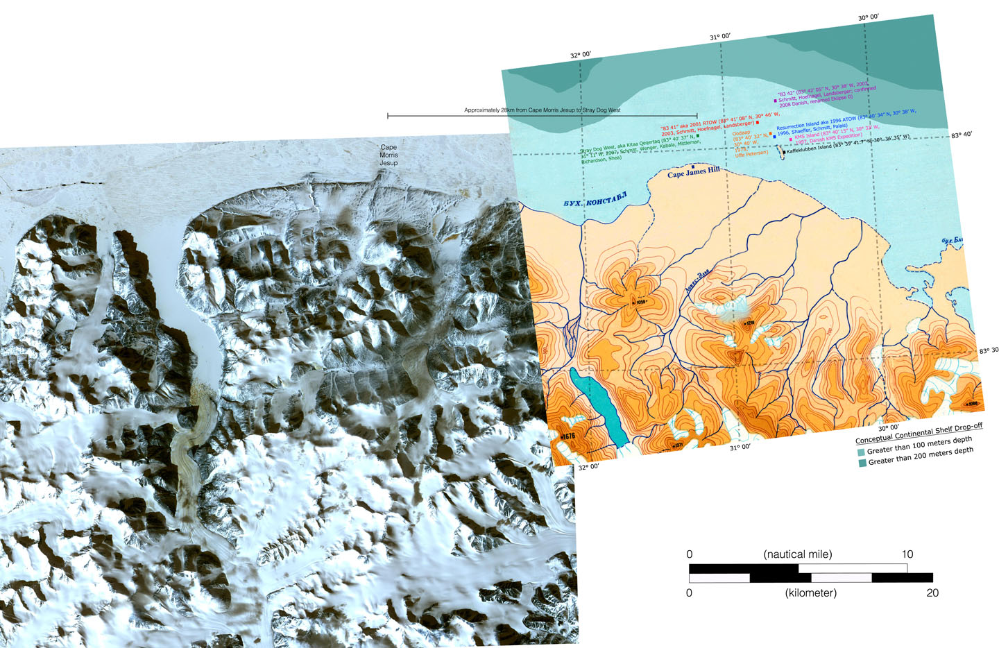
83-42 is a rocky islet in the Arctic Ocean which may be the northernmost permanent point of land on Earth. It is also sometimes referred to as Eklipse 0,[1] or Schmitt’s Island, after its discoverer, Dennis Schmitt.[2][3] It measures 35 by 15 metres (115 by 49 ft) and 4 metres (13 ft) in height, and lies 699.8 kilometres (434.8 mi) from the North Pole.[4] When it was discovered in 1998, lichens were found growing on it, suggesting it was not one of the temporary gravel bars commonly found in that region.[citation needed]

The island was discovered on 6 July 2003 by an American expedition led by Dennis Schmitt and Frank Landsberger. The expedition members gave it the unofficial name 83-42, reflecting its latitude of 83 degrees 42 minutes north.
To be recognized as land area it is required that the area permanently rise out of the water, even at high tide. Given its very small size, it is doubtful whether 83-42 has this property. According to its discoverer, 83-42 is composed of rocks and boulders, a relatively resistant material, and is not just a fleeting sand and gravel bank. The height of about four metres (13 feet) above the water surface could indicate that 83-42 is a permanent island given the weak tidal effect in the Arctic Ocean. As of November 2007, however, the island was not officially recognized as land area.[citation needed]
In most geography books, Kaffeklubben Island is still listed as the northernmost point of land. If 83-42 is granted status as land, it will be the northernmost land area on Earth. Since the classification of a land area as an island is not dependent on the size of the land area, 83-42 would also become the most northerly island in the world. Other islands which have been proposed as the northernmost include ATOW1996, RTOW2001, and Oodaaq. However, these are not thought to be permanent islands, but rather semi-permanent gravel banks, moved around by waves and ice floes.
References
- "relief map". jeffshea.org. Retrieved February 19, 2018.
- Charles Burress (June 17, 2004). "Romancing the North". San Francisco Chronicle. Retrieved September 23, 2011.
- Richard Fisher (April 25, 2007). "A new Arctic island is born into our warming world". New Scientist. Retrieved September 23, 2011.
- "10 Unique And Amazing Places on Earth". Listverse. 18 December 2009. Retrieved 1 June 2017.
На других языках
- [en] 83-42
[it] 83-42
83-42 è il nome di un'isola rocciosa, posizionata nell'Oceano Artico, che si ipotizza essere il territorio stabile (quindi che non può essere cancellato da eventi atmosferici e/o marini) posto più vicino al Polo Nord. L'isola è meglio nota come isola di Schmitt, dal nome del suo primo scopritore.[1][2][ru] 83-42
83-42 — скалистый островок в Северном Ледовитом океане, который претендует на звание самой северной точки суши на Земле. Его также называют остров Шмидта в честь его первооткрывателя Денниса Шмидта[1][2]. Он имеет размеры 35 на 15 м и высоту 4 м и находится в 699,8 километрах от Северного Полюса[3]. Когда он был обнаружен в 1998 году, на нём были найдены растущие лишайники, что свидетельствовало от том, что это не просто временный гравийный бар, которые так часто встречаются в этой местности.Другой контент может иметь иную лицензию. Перед использованием материалов сайта WikiSort.org внимательно изучите правила лицензирования конкретных элементов наполнения сайта.
WikiSort.org - проект по пересортировке и дополнению контента Википедии