geo.wikisort.org - Island
The Izu Islands (伊豆諸島, Izu-shotō) are a group of volcanic islands stretching south and east from the Izu Peninsula of Honshū, Japan.[1] Administratively, they form two towns and six villages; all part of Tokyo Prefecture. The largest is Izu Ōshima, usually called simply Ōshima.
This article needs additional citations for verification. (December 2007) |

Although usually called the "Seven Islands of Izu" (伊豆七島 in Japanese), there are in fact more than a dozen islands and islets. Nine among them are currently inhabited.
Geography


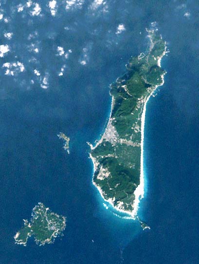
Right: A beach on Niijima

The Izu islands stretch south-east from the Izu Peninsula on Honshu and cover an area of approximately 301.56 km2 (116.43 sq mi). There are nine populated islands with a total population of 24,645 people (as of 2009[update]) spread over 296.56 km2 (114.50 sq mi). The largest of them is Izu Oshima (8,346 inhabitants, 91.06 km2 (35.16 sq mi)), the smallest Toshima (292 inhabitants, 4.12 km2 (1.59 sq mi).)[citation needed] Of the inhabited islands, seven are traditionally referred to as the "Izu Seven": Oshima, Toshima, Niijima, Kozujima, Miyakejima, Hachijojima, and Mikurajima, though Shikinejima and Aogashima are sometimes included as well.[citation needed]
Each of the islands has its unique character: Oshima is noted for its active volcano Mt Mihara and camellias, Hachijojima for its former penal colony, Mikurajima for dolphin watching, Niijima for its numerous beaches, Kozujima for its white sandy shores, Hachijojima for its well-preserved unique culture, and Miyakejima for the 2001 volcanic eruption.[citation needed]
During the Edo period, Nii-jima, Miyake-jima, and Hachijō-jima served as places of exile for criminals.
The subtropical Ogasawara Islands, which are also administratively part of Tokyo, lie further to the south. They form a far-flung archipelago of over thirty (30) islands some 1,000 km (621 mi) due south of Tokyo.
Islands


- Udone-shima was inhabited during the Meiji era.
- Uninhabited since 1969 (then population 31, with a peak of 513)
- Tori-shima, the largest of the uninhabited islands, had a population of 150 until 1902, when all were killed by a volcanic eruption. Since then, the island has been uninhabited.
Administrative divisions
The Izu Islands are divided into two towns (Oshima and Hachijojima) and six villages (remaining inhabited islands.) Three subprefectures are formed above the municipalities as branch offices of the metropolitan government.[citation needed]
All the islands (more than a dozen in total) lie within the Fuji-Hakone-Izu National Park.[citation needed] The four southernmost islands are not administrated under any town or village in Hachijō Subprefecture, but are unincorporated areas. Torishima is now uninhabited but is an important bird refuge.
Deserted islands between Aogashima and Ogasawara Islands, namely Bayonaise Rocks (Beyonēzu Retsugan), Smith Island (Sumisu-tō), Torishima, and Lot's Wife (Sōfu-iwa) do not belong to any municipality, because both Hachijō Town and Aogashima Village claim administrative rights. They are directly controlled by Hachijō Subprefecture instead.
- Ōshima Subprefecture
 Ōshima Town: Izu Ōshima
- Toshima Village: Toshima
- Niijima Village: Niijima, Shikinejima, and Udoneshima
- Kōzushima Village: Kōzushima
- Miyake Subprefecture
- Miyake Village: Miyakejima and Ōnoharajima
- Mikurajima Village: Mikurajima, Inambajima
- Hachijō Subprefecture
Demographics
Though the population on the Izu Islands has been dropping, the phase is less dramatic than on other isolated Japanese islands.[citation needed]
| Year | Izu Islands | Isolated Japanese islands | Japan Total |
|---|---|---|---|
| 1960 | 38,707 | 923,062 | 94,301,623 |
| 1970 | 32,539 | 736,712 | 104,665,171 |
| 1980 | 31,902 | 630,536 | 117,060,396 |
| 1990 | 30,032 | 546,505 | 123,611,167 |
| 2000 | 28,756 | 472,312 | 126,925,843 |
| 2005 | 26,242 | 422,712 | 127,767,994 |
The divergent Hachijō language is spoken on the islands.
Infrastructure

The primary industries are fisheries, agriculture, and tourism. The most scenic spots on the islands are crowded with tourists during summers. Popular tourist activities include swimming, scuba diving, surfing, fishing, bird watching and trekking.[citation needed]
Transportation between the islands, by cargo-passengers boats, jetfoils, and aircraft, is supported by harbours on all inhabited islands and five airports (small islands can be reached by helicopter).[citation needed]
There are 5 airports, 15 harbors, and 19 fishing ports. Flights from Tokyo take 30 minutes, while boats take 7–10 hours and jetfoils make the route in about two hours. Transportation on the islands is considered important to the quality of life, which is why about 215 km (134 mi) of paved main roads have been constructed to serve various kinds of vehicles.[citation needed]
There was no electricity on the islands before 1953, but by 1962 98% of the area was receiving electricity.[citation needed]
Geology
The islands occupy the northern portion of the Izu–Bonin–Mariana Arc which extends to the Izu Peninsula and Mount Fuji on the Honshū mainland which are northern extensions of the Izu volcanic arc. The Izu arc ends there at a tectonic triple junction.
Volcanic activity is frequent in the area.[2] 31 people were killed when the research vessel Kaiyō Maru no 5 was destroyed during the 1953 eruption of Myōjin-shō. Volcanic activity, including the release of harmful gases, forced the evacuation of Miyake-jima in 2000. Residents were allowed to return permanently to the island in February 2005 but were required to carry gas masks in case of future volcanic emissions.[citation needed]
To handle the various types of natural disasters threatening the region, including tsunamis, storm, floods, and volcanism, Tokyo metropolitan government has developed prevention and safety measures, including hazard maps and evacuation guidance, radios, signs, and a transport system for emergency supplies.[citation needed]
Ecology
A chain of volcanic islands, the Izu Archipelago are oceanic islands that formed relatively recently (within a few million years) without any previous connection to mainland Japan. In contrast to isolated Pacific islands, such as Hawaii and the Galápagos, the Izu Islands are located near the mainland and have thus been frequently colonized by various species by overseas dispersal from the mainland or from adjacent islands. This make them interesting for the studies of ecological and evolutionary processes.[3]
Campanula (Bellflower) colonized the entire archipelago in a single event. Similarly, the Euhadra snails, endemic to Japan, populated the islands in a single event and all individuals on inhabited islands possess an identical haplotype. The Apodemus mice, on the other hand, colonized the islands from the mainland in two independent events.[3]
History
- 680 - Izu Province was established in the form of being separated from Suruga Province. At that time, the Izu islands belonged to Kamo-gun.[4]
- 1643 - Explorer Maarten Gerritsz Vries called it the De Vries Archipelago[5]
- November 14, 1871 (December 25, 1871) --- Due to the first prefectural integration, it became under the jurisdiction of Ashigara Prefecture.[6]
- 1876 (Meiji 9), April 18 - Due to the second prefectural integration, it became under the jurisdiction of Shizuoka Prefecture.[7]
- 1878 (Meiji 11), January 11 - will be under the jurisdiction of Tokyo Prefecture[8]
See also
References
- Nussbaum, Louis-Frédéric. (2005). "Izu Shotō," Japan Encyclopedia, p. 412.
- Volcanoes of the Izu, Volcano and Mariana Islands
- Kuriyama, Takeo; Brandley, Matthew C.; Katayama, Akira; Mori, Akira; Honda, Masanao; Hasegawa, Masami (2011). "A time-calibrated phylogenetic approach to assessing the phylogeography, colonization history and phenotypic evolution of snakes in the Japanese Izu Islands" (PDF). J. Biogeogr. 38 (2): 259–271. doi:10.1111/j.1365-2699.2010.02403.x. S2CID 55266255.
- 『日本歴史地名大系 22 静岡県の地名』平凡社、2000年。ISBN 4582490220。「伊豆国」の項目(P75.)。
- After Dutch explorer Maarten Gerritsz Vries, the first European to describe them in 1643. See "Izu Shotō" in Louis Frédéric, Japan Encyclopedia (Belknap, 2002), p. 412.
- 明治4年太政官布告第594号 - 国立国会図書館近代デジタルライブラリー
- 明治9年太政官布告第53号 - 国立国会図書館近代デジタルライブラリー
- 明治11年太政官布告第1号 - 国立国会図書館近代デジタルライブラリー
- Teikoku's Complete Atlas of Japan, Teikoku-Shoin Co., Ltd. Tokyo 1990, ISBN 4-8071-0004-1
- The official tokyo island information page[1]
Authority control | |
|---|---|
| General | |
| National libraries | |
- "Tokyo Islands: The 9 exotic islands of Tokyo, Izu Islands". Tokyo Islands. Retrieved 2022-03-20.
На других языках
[de] Izu-Inseln
Die Izu-Inseln (japanisch .mw-parser-output .Hani{font-size:110%}伊豆諸島 .mw-parser-output .Latn{font-family:"Akzidenz Grotesk","Arial","Avant Garde Gothic","Calibri","Futura","Geneva","Gill Sans","Helvetica","Lucida Grande","Lucida Sans Unicode","Lucida Grande","Stone Sans","Tahoma","Trebuchet","Univers","Verdana"}Izu-shotō) sind eine Inselkette, die sich südöstlich der Izu-Halbinsel von der Insel Honshū aus in Südrichtung in den Pazifik erstreckt. Sie liegen rund 100 bis 350 km von der japanischen Hauptstadt Tōkyō entfernt und sind Teil der Präfektur Tokio.- [en] Izu Islands
[es] Islas Izu
El archipiélago Izu (伊豆諸島, Izu shōtō?) es un grupo de islas volcánicas que se extienden al sur y están al este de la península de Izu en Honshu, Japón. Administrativamente, forman parte de la prefectura de Tokio, dividiéndose en tres subprefecturas (hay algunas islas no incorporadas a ninguna subprefectura). La mayor de las islas es Ōshima o Izu Ōshima. Todas las islas forman parte del Parque Nacional Fuji-Hakone-Izu.[fr] Archipel d'Izu
L'archipel d'Izu (伊豆諸島, Izu shotō?) est un groupe d'îles japonaises d'origine volcanique situées en mer des Philippines, au sud-est du cap d'Izu sur Honshū et au sud de la baie de Sagami. Les îles dépendent administrativement de la préfecture de Tokyo. L'archipel forme, avec l'archipel Ogasawara au sud, l'archipel Nanpō, qui s'étend le long de la fosse océanique d'Izu Bonin.[it] Isole Izu
Le Isole Izu (伊豆諸島 Izu-shotō?) sono un arcipelago che si estende a sudovest della Penisola di Izu dall'isola giapponese di Honshū, in direzione sud nell'Oceano Pacifico. Si trovano all'incirca da 100 a 350 km da Tōkyō, alla cui prefettura appartengono da un punto di vista amministrativo. Le isole sono di origine vulcanica e giacciono sulla stessa dorsale marina sulla quale, 290 km più avanti, si trovano le Isole Ogasawara.[ru] Идзу (острова)
Идзу (яп. 伊豆諸島 Идзу-сёто:) — цепь островов, расположенных в Тихом океане, к юго-востоку от находящегося на острове Хонсю полуострова Идзу. Принадлежат Японии. Административно входят в префектуру Токио.Другой контент может иметь иную лицензию. Перед использованием материалов сайта WikiSort.org внимательно изучите правила лицензирования конкретных элементов наполнения сайта.
WikiSort.org - проект по пересортировке и дополнению контента Википедии