geo.wikisort.org - Island
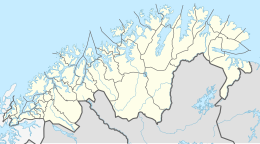
Ingøya (Northern Sami: Fávle-Iččát) is an island on the edge of the Arctic Ocean in Måsøy Municipality in Troms og Finnmark county, Norway. The 18-square-kilometre (6.9 sq mi) island lies just north of the island of Rolvsøya and west of the island of Hjelmsøya. The sparsely populated island is only accessible by boat.
Native name: Fávle-Iččát | |
|---|---|
 | |
 | |
 Ingøya Location of the island  Ingøya Ingøya (Norway) | |
| Geography | |
| Location | Troms og Finnmark, Norway |
| Coordinates | 71.0595°N 23.9676°E |
| Area | 18 km2 (6.9 sq mi) |
| Length | 7.8 km (4.85 mi) |
| Width | 5 km (3.1 mi) |
| Highest elevation | 332 m (1089 ft) |
| Highest point | Mafjordfjellet |
| Administration | |
Norway | |
| County | Troms og Finnmark |
| Municipality | Måsøy |
There are regular ferry connections at the port in the village of Ingøy on the north side of the island. The ferry connects to Gunnarnes on Rolvsøya and Havøysund on the island of Havøya. The island has about 13 inhabitants (2022). The Ingøy radio transmitter is located about 2 kilometres (1.2 mi) south of the village of Ingøy. Fruholmen Lighthouse lies just off the northern coast of the island.[1]
From the northwest, the broad Mafjorden cuts into the island of Ingøya and on the east side there is an open bay called Sanden.
The southwestern part of the island is quite mountainous with the highest peak being the 332-metre (1,089 ft) tall Mafjordfjellet. The southern and eastern parts of the island are flat and partially swampy. The northern part is a more mountainous part where the fishing village of Ingøy is located. Ingøy Church is located in Ingøy village. Historically, Mafjorden, Gåsnes, and Ingøy were all large fishing villages. There were two whaling stations located in Mafjorden that operated until the early 20th century.[1][2]
See also
References
External links
На других языках
[de] Ingøy
Ingøy (samisch: Fávle-Ižžát) ist eine Insel 60 Kilometer westlich des Nordkaps, in der norwegischen Kommune Måsøy in Troms og Finnmark. Ingøy hat eine Fläche von 18,1 km², der höchste Punkt der Insel ist das Mafjordfjell mit 332 moh. Die Insel hat zirka 25 Einwohner.- [en] Ingøya
[es] Ingoy
Ingøy es una isla del mar de Noruega localizada unos 60 km al oeste de cabo Norte, en el municipio de Måsøy, en Laponia, Noruega. Tiene un área total de 18,1 kilómetros cuadrados, y el punto más alto de la isla es el Mafjordfjell, con 332 metros. La isla tiene alrededor de 25 habitantes.[fr] Ingøya
Ingøy est une île située soixante kilomètres à l'ouest du cap Nord, dans la municipalité norvégienne de Måsøy, appartenant au comté de Finnmark.Другой контент может иметь иную лицензию. Перед использованием материалов сайта WikiSort.org внимательно изучите правила лицензирования конкретных элементов наполнения сайта.
WikiSort.org - проект по пересортировке и дополнению контента Википедии