geo.wikisort.org - Island
Ilhéu das Rolas (also: Ilheu Gago Coutinho) is an islet in the African island nation of São Tomé and Príncipe. The island lies on the Equator, off the southern tip of São Tomé Island, separated by Canal das Rolas. Its maximum elevation is 96 m (315 ft).[1] Its population is 76 (2012 census).[2] It is part of the Caué District. Access is only by ferry departing from Ponta Baleia on São Tomé Island. There is a lighthouse on the islet, built in 1929.[3] Its focal height is 106 metres (348 ft) and its range is 12 nmi (22 km; 14 mi).[4] The island is home to a small resort, the Pestana Equador.
| Year | Pop. | ±% |
|---|---|---|
| 2001[5] | 224 | — |
| 2008[5] | 255 | +13.8% |
| 2012[2] | 76 | −70.2% |


 Map of São Tomé and Príncipe | |
| Geography | |
|---|---|
| Coordinates | 0°0′14″S 6°31′21″E |
| Area | 2 km2 (0.77 sq mi) |
| Highest elevation | 96 m (315 ft) |
| Highest point | Mount São Francisco |
| Administration | |
São Tomé and Príncipe | |
| District | Caué |
| Demographics | |
| Population | 76 (2012) |
History
The island was mentioned as "Illie de Rolle" in a 1665 map by Johannes Vingboons.[6] and as "I. de Rolle" in a 1780 map by A. Dalrymple.[7]
Gago Coutinho (1869–1959), officer of the Portuguese Navy, navigator and historian, headed a geodesic mission to São Tomé between 1915 and 1918, when marks were placed as a basis for a geodetic network in the archipelago. After that, observations for triangulation, precise base measurement and astronomical observations were made.
In the process, Gago Coutinho proved that Ilhéu das Rolas is crossed by the equatorial line. The resulting map was published in 1919, together with the Report of the Geodetic Mission on São Tomé Island 1915–1918, that was officially considered the first complete work of practical geodesy in the Portuguese colonies.
Nature
The islet is abundant in flora and fauna. Some endemic species are Greeff’s giant gecko,[8] birds such as the São Tomé prinia and the São Tomé weaver and frogs such as Phrynobatrachus leveleve and Schistometopum thomense.
Gallery
 Praia de Santo António
 Beach scenery in São Tomé and Príncipe
 Ilhéu das Rolas, STP
 Ilhéu das Rolas
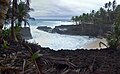 São Tomé and Príncipe
 STP
STP Beach close to Ilhéu das Rolas, São Tomé and Príncipe
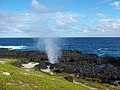 Furnas, a blowhole in Rolas


References
- Sailing Directions (Enroute), Pub. 123: Southwest Coast of Africa (PDF). Sailing Directions. United States National Geospatial-Intelligence Agency. 2017. p. 76.
- 2012 detailed census São Tomé e Príncipe Archived 2019-03-27 at the Wayback Machine, Instituto Nacional de Estatística
- Rowlett, Russ. "Lighthouses of São Tomé and Príncipe". The Lighthouse Directory. University of North Carolina at Chapel Hill.
- List of Lights, Pub. 113: The West Coasts of Europe and Africa, the Mediterranean Sea, Black Sea and Azovskoye More (Sea of Azov) (PDF). List of Lights. United States National Geospatial-Intelligence Agency. 2018. p. 442.
- "Evolução da população São-Tomense por localidades, 2001/2007-08" (PDF). Instituto Nacional de Estatística. Archived from the original (PDF) on 2017-02-09.
- 1665 map of the island of São Tomé by Johannes Vingboons, now at the Dutch National Archive
- 1780 map of the island of São Tomé by T. Harmar and A. Dalrymple, now at the French National Library
- Hemidactylus greeffii at the Reptarium.cz Reptile Database. Accessed 2018-02-13.
| Wikimedia Commons has media related to Ilhéu das Rolas. |
| Major islands | |
|---|---|
| Minor islands and islets | |
Caué District | ||
|---|---|---|
| Settlements |
|  |
| Geographical features |
| |
| Culture | ||
На других языках
[de] Rolas (São Tomé und Príncipe)
Rólas (pt. Ilhéu das Rólas), auch Ilhéu Gago Coutinho, ist eine stratovulkanische Insel im Golf von Guinea, die zum Inselstaat São Tomé und Príncipe gehört. Sie liegt direkt am Äquator knapp 1100 Meter südlich der Insel São Tomé, von der sie durch den Canal das Rôlas getrennt und von wo aus sie per Boot erreichbar ist.- [en] Ilhéu das Rolas
[es] Ilhéu das Rolas
Ilhéu das Rolas o islote de las Tórtolas es un islote que pertenece al país de Santo Tomé y Príncipe, en el golfo de Guinea, es el tercero en tamaño de todo el país. El islote se encuentra al sur de la costa de la isla de Santo Tomé, a 0º N 6º O. Es conocido por estar sobre la línea ecuatorial, siendo la tierra emergida más próxima al centro geográfico terrestre (la intersección entre la línea ecuatorial y el Meridiano de Greenwich). Posee playas, palmeras, un faro y un hotel turístico. Hay una población permanente de solamente 76 personas.[fr] Rolas
L'îlot de Rolas[1] fait partie de l'État-archipel de Sao Tomé-et-Principe situé dans le centre-est de l'Atlantique à 350 km des côtes du Gabon et au sud de l'île capitale de São Tomé dans le golfe de Guinée.[it] Ilhéu das Rolas
Ilhéu das Rolas è una piccola isola dello Stato di São Tomé e Príncipe, in Africa. L'isola, posta poco più a sud di quella principale di São Tomé, giace sulla linea dell'equatore. Si trova nel distretto di Caué nella provincia di São Tomé.[ru] Ролаш
Ро́лаш (порт. Ilhéu das Rolas) — небольшой островок вулканического происхождения в Гвинейском заливе Атлантического океана приблизительно в двух километрах к югу от острова Сан-Томе, лежащий почти на экваторе. Входит в состав округа Кауи (государство Сан-Томе и Принсипи). На острове расположен небольшой курорт, доступный только морским путём - Pestana Equador, поэтому почти вся экономическая деятельность на острове сосредоточена в сфере туризма.Другой контент может иметь иную лицензию. Перед использованием материалов сайта WikiSort.org внимательно изучите правила лицензирования конкретных элементов наполнения сайта.
WikiSort.org - проект по пересортировке и дополнению контента Википедии