geo.wikisort.org - Island
Iki Island (壱岐島, Iki-no-shima), or the Iki Archipelago (壱岐諸島, Iki-shotō), is an archipelago in the Tsushima Strait, which is administered as the city of Iki in Nagasaki Prefecture, Japan. The islands have a total area of 138.46 square kilometres (53.46 sq mi) with a total population of 28,008. Only four (4) of the twenty-three (23) named islands are permanently inhabited. Together with the neighboring islands of Tsushima, they are collectively within the borders of the Iki–Tsushima Quasi-National Park.
Native name: 壱岐島, Iki-no-shima, Iki rettō | |
|---|---|
Map of Iki-no-shima | |
 Map of Nagasaki Prefecture with Iki Islands in red | |
 Iki Location of Iki Islands 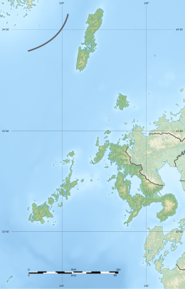 Iki Iki (Nagasaki Prefecture) | |
| Geography | |
| Coordinates | 33°47′N 129°43′E |
| Adjacent to | Tsushima Strait |
| Total islands | 4 inhabited, 18 total |
| Area | 138.46 km2 (53.46 sq mi) |
| Highest elevation | 212.9 m (698.5 ft) |
| Highest point | Takenotsuji |
| Administration | |
Japan | |
| Prefectures | Nagasaki |
| City | Iki |
| Demographics | |
| Population | 28,008 (2013) |
| Pop. density | 202/km2 (523/sq mi) |
| Ethnic groups | Japanese |

Geology
The Iki Islands are volcanic in origin: they are the exposed and eroded basaltic summit of a massive Quaternary stratovolcano last active over 400,000 years ago.
Iki Island is slightly oval in shape, and measures approximately 17 kilometres (11 mi) from north-south and 14 kilometres (8.7 mi) from east-west. The highest elevation is Takenotsuji (岳ノ辻), a weakly curved peak with a highest elevation at 212.9 metres (698 ft) above sea level. The average height of the land surface is 100 meters above sea level.
The archipelago is approximately 20 kilometres (11 nmi) north-northeast of the Kyushu coast at its closest point and southeast of the Tsushima Islands.
History
The Iki Islands have been inhabited since the Japanese Paleolithic era, and numerous artifacts from the Jōmon, Yayoi and Kofun periods have been found by archaeologists, indicating continuous human occupation and activity. In the Chinese Wèizhì Wōrén chuán (Japanese 魏志倭人伝, Gishi Wajinden), part of the Records of the Three Kingdoms dating from the third century, mention is made of a country called “Iki”, (一支国, Iki-koku), located on an archipelago east of the Korean Peninsula. Archaeologists have tentatively identified this with the large Yayoi period settlement of Harunotsuji, one of the largest to have been discovered in Japan, where artifacts uncovered indicate a close contact with the Japanese islands and the Asian mainland.
The islands were organized as Iki Province under the Ritsuryō reforms in the latter half of the seventh century, and the name Iki-no-kuni appears on wooden markers found in the imperial capital of Nara.
During the Heian period, the island was attacked by Jurchen pirates in the Toi invasion of 1019. Afterwards, the islands came under the rule of the Matsura clan, who developed trade and commercial relations between Goryeo in Korea, Tsushima, Iki and Kyushu. However, the islands were again devastated by the Kamakura period Mongol invasions of Japan in 1274 and 1281 during which time many of its inhabitants were slaughtered. Throughout the Muromachi period, the islands were a main base for the Japanese Wokou pirates, who plundered coastal settlements in Korea and China. Following the establishment of the Tokugawa shogunate in the Edo period, the islands came under the rule of Hirado Domain.
Following the Meiji Restoration, the islands became part of "Hirado Prefecture" from 1871, which then became part of Nagasaki Prefecture.
The islands were fortified with numerous coastal artillery batteries during World War II, but did not experience any combat. Remains of these fortifications can be found on the island of Wakamiyajima, north of the main Iki Island. On November 18, 1948, Lt. William Downham, from the USAF 36th Fighter Group stationed at Ashiya Air Field, experienced engine failure in his North American P-51 Mustang while patrolling the Korea Strait between Japan and the Korean Peninsula. He successfully parachuted onto Iki Island.[1]
In the 1960s and 1970s, in particularly the town of Iki, the islanders were notorious for overfishing, but blamed declining catches on the local species of whales and dolphins. In 1977, the local fishermen invited television companies to film the mass slaughter of dolphins. In response, activists heavily condemned the fishermen's acts of killing the dolphins.[citation needed] In view of the already endangered Japanese amberjack, the local town government banned large-scale, commercial fishing of Japanese amberjack after 1982.[citation needed]
Climate
| Climate data for Isida, Iki (2003−2020 normals, extremes 2003−present) | |||||||||||||
|---|---|---|---|---|---|---|---|---|---|---|---|---|---|
| Month | Jan | Feb | Mar | Apr | May | Jun | Jul | Aug | Sep | Oct | Nov | Dec | Year |
| Record high °C (°F) | 19.0 (66.2) |
20.2 (68.4) |
22.7 (72.9) |
25.1 (77.2) |
29.1 (84.4) |
29.6 (85.3) |
33.9 (93.0) |
35.0 (95.0) |
32.6 (90.7) |
30.2 (86.4) |
24.6 (76.3) |
23.4 (74.1) |
35.0 (95.0) |
| Average high °C (°F) | 9.6 (49.3) |
10.9 (51.6) |
13.6 (56.5) |
17.7 (63.9) |
21.8 (71.2) |
24.3 (75.7) |
28.3 (82.9) |
30.1 (86.2) |
26.7 (80.1) |
22.5 (72.5) |
17.6 (63.7) |
12.0 (53.6) |
19.6 (67.3) |
| Daily mean °C (°F) | 6.4 (43.5) |
7.7 (45.9) |
10.4 (50.7) |
14.3 (57.7) |
18.4 (65.1) |
21.5 (70.7) |
25.5 (77.9) |
27.1 (80.8) |
24.1 (75.4) |
19.5 (67.1) |
14.3 (57.7) |
8.6 (47.5) |
16.5 (61.7) |
| Average low °C (°F) | 2.6 (36.7) |
3.9 (39.0) |
6.6 (43.9) |
10.8 (51.4) |
15.2 (59.4) |
19.3 (66.7) |
23.5 (74.3) |
24.7 (76.5) |
21.8 (71.2) |
16.4 (61.5) |
10.3 (50.5) |
4.5 (40.1) |
13.3 (55.9) |
| Record low °C (°F) | −4.9 (23.2) |
−5.6 (21.9) |
−1.9 (28.6) |
1.8 (35.2) |
7.1 (44.8) |
12.3 (54.1) |
17.6 (63.7) |
17.7 (63.9) |
13.5 (56.3) |
7.3 (45.1) |
1.2 (34.2) |
−2.7 (27.1) |
−5.6 (21.9) |
| Average precipitation mm (inches) | 65.7 (2.59) |
75.4 (2.97) |
116.5 (4.59) |
137.9 (5.43) |
141.2 (5.56) |
257.3 (10.13) |
327.3 (12.89) |
249.0 (9.80) |
150.2 (5.91) |
106.5 (4.19) |
90.9 (3.58) |
80.0 (3.15) |
1,797.8 (70.78) |
| Average rainy days (≥ 1.0 mm) | 7.8 | 8.9 | 9.2 | 8.9 | 8.1 | 10.3 | 11.0 | 8.9 | 9.8 | 6.7 | 8.0 | 8.4 | 106 |
| Source 1: JMA[2] | |||||||||||||
| Source 2: JMA[3] | |||||||||||||
| Climate data for Ashibe, Iki (1991−2020 normals, extremes 1977−present) | |||||||||||||
|---|---|---|---|---|---|---|---|---|---|---|---|---|---|
| Month | Jan | Feb | Mar | Apr | May | Jun | Jul | Aug | Sep | Oct | Nov | Dec | Year |
| Record high °C (°F) | 18.6 (65.5) |
21.2 (70.2) |
22.5 (72.5) |
26.9 (80.4) |
29.7 (85.5) |
30.5 (86.9) |
34.6 (94.3) |
34.6 (94.3) |
33.0 (91.4) |
29.7 (85.5) |
25.7 (78.3) |
22.7 (72.9) |
34.6 (94.3) |
| Average high °C (°F) | 8.7 (47.7) |
9.7 (49.5) |
12.7 (54.9) |
17.2 (63.0) |
21.5 (70.7) |
24.3 (75.7) |
28.1 (82.6) |
29.7 (85.5) |
26.1 (79.0) |
21.6 (70.9) |
16.4 (61.5) |
11.2 (52.2) |
18.9 (66.1) |
| Daily mean °C (°F) | 6.2 (43.2) |
6.9 (44.4) |
9.7 (49.5) |
13.7 (56.7) |
17.7 (63.9) |
20.9 (69.6) |
24.9 (76.8) |
26.3 (79.3) |
23.1 (73.6) |
18.7 (65.7) |
13.7 (56.7) |
8.5 (47.3) |
15.9 (60.6) |
| Average low °C (°F) | 3.7 (38.7) |
4.3 (39.7) |
7.0 (44.6) |
10.8 (51.4) |
14.8 (58.6) |
18.5 (65.3) |
22.7 (72.9) |
23.9 (75.0) |
21.0 (69.8) |
16.4 (61.5) |
11.0 (51.8) |
5.8 (42.4) |
13.3 (56.0) |
| Record low °C (°F) | −5.5 (22.1) |
−5.6 (21.9) |
−1.5 (29.3) |
1.8 (35.2) |
9.0 (48.2) |
12.0 (53.6) |
16.6 (61.9) |
17.4 (63.3) |
14.4 (57.9) |
6.6 (43.9) |
1.7 (35.1) |
−3.4 (25.9) |
−5.6 (21.9) |
| Average precipitation mm (inches) | 76.1 (3.00) |
78.6 (3.09) |
127.8 (5.03) |
148.7 (5.85) |
165.0 (6.50) |
273.1 (10.75) |
316.1 (12.44) |
250.9 (9.88) |
173.7 (6.84) |
94.1 (3.70) |
97.5 (3.84) |
79.4 (3.13) |
1,881 (74.05) |
| Average rainy days (≥ 1.0 mm) | 8.5 | 8.3 | 10.1 | 9.4 | 8.9 | 11.6 | 10.9 | 9.5 | 10.4 | 7.3 | 7.9 | 7.8 | 110.6 |
| Mean monthly sunshine hours | 124.9 | 138.3 | 169.8 | 190.2 | 199.4 | 134.0 | 174.5 | 195.0 | 159.2 | 174.2 | 146.9 | 133.8 | 1,940.2 |
| Source 1: JMA[4] | |||||||||||||
| Source 2: JMA[5] | |||||||||||||
Transportation
Iki Island has ferry terminals in Ashibe, Ishida and Gōnoura, which connect Iki to mainland Japan such as Fukuoka and Kitakyushu. Located on the east coast Iki Airport connects the island to Nagasaki Airport in Nagasaki. The Japan National Route 382 connects the hamlets of the island together, and the bus company "Iki-kōtsu" provides for public transport.
Islands
| Photo | Name | Kanji | Area [km²] | Population | highest point [m] | Peak | Coordinates |
|---|---|---|---|---|---|---|---|
 |
Iki Island | 壱岐島 | 133.8 | 13,178 | 213 | Takenotsuji | 33°47′N 129°43′E |
| Harushima | 原島 | 0.53 | 140 | 33°43′23″N 129°38′56″E | |||
| Nagashima | 長島 | 0.51 | 170 | 33°43′38″N 129°37′53″E | |||
| Oshima | 大島 | 1.16 | 200 | 33°44′17″N 129°38′5″E | |||
 |
Wakamiyajima | 若宮島 | 0.35 | - | 99.7 | 33°51′56″N 129°41′11″E | |
References
- National Geospatial Intelligence Agency (NGIA). Prostar Sailing Directions 2005 Japan Enroute. Prostar Publications (2005). ISBN 1577856511
- "Iki Volcanic Group". Global Volcanism Program. Smithsonian Institution. Retrieved 2021-06-25.
Notes
- http://www.aviationarchaeology.com, http://www.accident-report.com/USAF.html
- 観測史上1~10位の値(年間を通じての値). JMA. Retrieved February 17, 2022.
- 気象庁 / 平年値(年・月ごとの値). JMA. Retrieved February 17, 2022.
- 観測史上1~10位の値(年間を通じての値). JMA. Retrieved February 17, 2022.
- 気象庁 / 平年値(年・月ごとの値). JMA. Retrieved February 17, 2022.
Authority control | |
|---|---|
| General | |
| National libraries | |
На других языках
[de] Iki (Insel)
Iki (japanisch 壱岐島, Iki no shima, wörtlich: „Einkap-Insel“) ist eine japanische Insel, die sich in 20 km Entfernung nordnordwestlich vor Kyūshūs Halbinsel Higashi-Matsuura und südöstlich der Tsushima-Inseln befindet.- [en] Iki Island
[es] Isla Iki
La isla de Iki (壱岐島) es una isla de la región de Kyushu y pertenece al archipiélago de Tsushima. El conjunto de islas se encuentra entre el estrecho de Tsushima y el canal este del estrecho de Corea. La isla de Iki es parte de la prefectura de Nagasaki. La ciudad de Iki es el centro de gobierno local y la isla cuenta con tres puertos.[fr] Île Iki
L'île d'Iki (壱岐島, Iki-no-shima?), ou l'archipel d'Iki (壱岐諸島, Iki-shotō?), est un archipel situé dans le détroit de Tsushima, administré sous le nom de ville d'Iki dans la préfecture de Nagasaki, au Japon. Les îles ont une superficie totale de 138,46 km2 avec une population totale de 28 008 habitants. Seules quatre des vingt-trois îles nommées sont habitées en permanence. Avec les îles voisines de Tsu-shima, elles se trouvent dans les limites du parc quasi national d'Iki-Tsushima.[ru] Ики (остров)
Ики (яп. 壱岐島 Ики-но сима) — японский остров в Цусимском проливе, в 20 км от берегов Кюсю; административно входит в префектуру Нагасаки. Главный населенный пункт на острове — город Ики.Другой контент может иметь иную лицензию. Перед использованием материалов сайта WikiSort.org внимательно изучите правила лицензирования конкретных элементов наполнения сайта.
WikiSort.org - проект по пересортировке и дополнению контента Википедии