geo.wikisort.org - Island
Ikema Island (池間島, Ikema-jima, Miyako: Ikyaama (イキャーマ)), is located to the north of Miyako Island in Okinawa Prefecture, Japan. The island is connected to Miyako Island with a 1,425-metre-long (4,675 ft) bridge (池間大橋), which was completed in February 1992.[3][1] There is a pond in the centre of the island. To the north-east is the Ikema-jima Block Beach (池間島ブロックビーチ). The variety of Miyakoan language spoken here is also called Ikema (Ikima in the vernacular). It is set apart from closely related language variants by its lexical word-tone system.[4]
 Ikema bridge connects Ikema Island with Miyako Island. It's 1,425-metre-long (4,675 ft).
 Ikemajima Block Beach


This article needs additional citations for verification. (November 2011) |
Native name: Ikema-jima (池間島) | |
|---|---|
 Aerial view of Ikema-jima from southeast | |
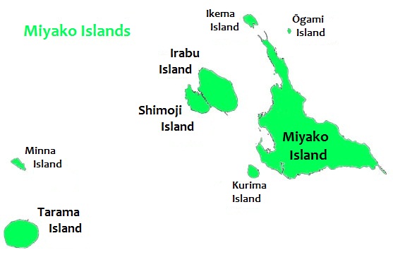 Ikema Island is located to the north of Miyako Island | |
| Geography | |
| Location | Okinawa Prefecture |
| Coordinates | 24°55′N 125°15′E |
| Archipelago | Miyako Islands |
| Area | 2.83 km2 (1.09 sq mi)[1] |
| Highest elevation | 28 m (92 ft) |
| Highest point | Unknown |
| Administration | |
Japan | |
| Demographics | |
| Population | 774[2] (2018) |
| Ethnic groups | Ryukyuan, Japanese |
See also
- Ikema Wetland
- Sakishima Beacons
References
- "Department of Land and Islands, Planning Department, Okinawa Prefecture (指定離島・指定離島一覧)" (PDF). Archived (PDF) from the original on 27 August 2019. Retrieved 30 January 2020.
- "Ikema island tourism information site", 池間ねっと, 2018. Retrieved on 13 January 2018.
- "Ikema Ohashi", 池間ねっと, 2018. Retrieved on 13 January 2018.
- Shimoji, Michinori; Pellard, Thomas (2010). An Introduction to Ryukyuan Languages. Research Institute for Languages and Cultures of Asia and Africa. pp. 167–188. ISBN 978-4-86337-072-2.
Naha (capital) | ||
| Core city |
| |
| Cities | ||
| Districts |
| |
List of mergers in Okinawa Prefecture
| ||
This Okinawa Prefecture location article is a stub. You can help Wikipedia by expanding it. |
На других языках
- [en] Ikema Island
[es] Isla Ikema
La isla Ikema[1] (en japonés: Ikemajima 池間島) está situada al norte de la isla de Miyako, en la prefectura de Okinawa, al sur del país asiático de Japón. Tiene una superficie es de 2,83 km². La isla está conectada con la también isla de Miyako, a través de un puente de que mide 1592 m. Hay un estanque en el centro de la isla. Hacia el noreste esta la playa bloque de Ikema-jima.[fr] Ikema-jima
Ikema-jima est une île des îles Miyako, en mer de Chine orientale. Elle fait partie de l'archipel Sakishima, lui-même inclus dans l'archipel Ryūkyū. L'île dépend administrativement de la préfecture d'Okinawa, au Japon.[ru] Икэма
Икэ́ма (яп. 池間島 икэма-дзима) — небольшой остров в группе Мияко островов Сакисима архипелага Рюкю, Япония. Административно относится к округу Мияко уезда Мияко префектуры Окинава.Текст в блоке "Читать" взят с сайта "Википедия" и доступен по лицензии Creative Commons Attribution-ShareAlike; в отдельных случаях могут действовать дополнительные условия.
Другой контент может иметь иную лицензию. Перед использованием материалов сайта WikiSort.org внимательно изучите правила лицензирования конкретных элементов наполнения сайта.
Другой контент может иметь иную лицензию. Перед использованием материалов сайта WikiSort.org внимательно изучите правила лицензирования конкретных элементов наполнения сайта.
2019-2026
WikiSort.org - проект по пересортировке и дополнению контента Википедии
WikiSort.org - проект по пересортировке и дополнению контента Википедии