geo.wikisort.org - Island
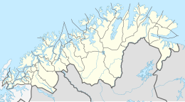
Håja (Norwegian) or Jievju (Northern Sami) is an unpopulated island in Hammerfest Municipality in Troms og Finnmark county, Norway. Håja is located in the Sørøysundet strait, between the larger islands of Kvaløya to the east, Seiland to the south, and Sørøya to the northwest. The town of Hammerfest lies about 8 kilometres (5.0 mi) to the east of Håja.[1]
 View of the island in May 2010 | |
 | |
 Håja Location of the island  Håja Håja (Norway) | |
| Geography | |
|---|---|
| Location | Troms og Finnmark, Norway |
| Coordinates | 70.6611°N 23.4410°E |
| Administration | |
Norway | |
| County | Troms og Finnmark |
| Municipality | Hammerfest Municipality |
On the island, there is a gull colony. Locals use the island for picking seagull eggs and berries, traditional ingredients of North Norwegian cuisine.
Several companies and institutions in Hammerfest have been named after Håja, including a kindergarten.
References
- "Håja, Hammerfest (Finnmark)" (in Norwegian). yr.no. Retrieved 2018-08-12.
На других языках
[de] Håja (Hammerfest)
Håja (norwegisch – dt. die hohe Insel) oder Jievju (nordsamisch) ist eine unbewohnte Insel in der Kommune Hammerfest (Provinz Troms og Finnmark) in Norwegen. Sie liegt etwa 8 km westlich der Stadt Hammerfest im Sørøysund (Europäisches Nordmeer), zwischen den Inseln Kvaløya im Osten, Seiland im Süden und Sørøya im Nordwesten. Die insgesamt felsige Insel hat an ihrer Südseite eine Steilküste von knapp 300 m Höhe. Auf der Insel befindet sich eine Vogelkolonie.- [en] Håja
Текст в блоке "Читать" взят с сайта "Википедия" и доступен по лицензии Creative Commons Attribution-ShareAlike; в отдельных случаях могут действовать дополнительные условия.
Другой контент может иметь иную лицензию. Перед использованием материалов сайта WikiSort.org внимательно изучите правила лицензирования конкретных элементов наполнения сайта.
Другой контент может иметь иную лицензию. Перед использованием материалов сайта WikiSort.org внимательно изучите правила лицензирования конкретных элементов наполнения сайта.
2019-2025
WikiSort.org - проект по пересортировке и дополнению контента Википедии
WikiSort.org - проект по пересортировке и дополнению контента Википедии