geo.wikisort.org - Island
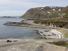
Sørøya (Northern Sami: Sállan) is Norway's fourth largest island in terms of area. The 811-square-kilometre (313 sq mi)[2] island is divided between Hasvik Municipality and Hammerfest Municipality. It is often claimed to be "one of the most beautiful" of the islands in Norway.[by whom?] In 2018, the population of the island was 1,100.[1]

Native name: Sállan | |
|---|---|
 View of the island | |
 | |
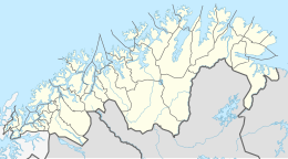
 Sørøya Location of the island  Sørøya Sørøya (Norway) | |
| Geography | |
| Location | Troms og Finnmark, Norway |
| Coordinates | 70°35′N 22°44′E |
| Area | 811 km2 (313 sq mi) |
| Area rank | 4th largest in Norway |
| Length | 64.3 km (39.95 mi) |
| Width | 23.3 km (14.48 mi) |
| Highest elevation | 659 m (2162 ft) |
| Highest point | Komagaksla |
| Administration | |
Norway | |
| County | Troms og Finnmark |
| Municipalities | Hammerfest Municipality and Hasvik Municipality |
| Demographics | |
| Population | 1,100[1] (2015) |
| Pop. density | 1.3/km2 (3.4/sq mi) |
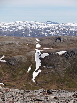
The island is very rocky and mountainous. The highest point on the island is the 659-metre (2,162 ft) tall mountain Komagaksla on the southern shore of the island. The coastline is very jagged and has numerous fjords that cut inland from the open ocean. The island is surrounded by the Norwegian Sea on the north and the Sørøysundet strait to the south. Across the Sørøysundet to the south are three large islands: Stjernøya, Seiland and Kvaløya. The island of Sørøya has no bridge or tunnel access, only a regular ferry route from the village of Hasvik to the village of Øksfjord on the mainland. Hasvik Airport is located on the southern tip of the island.
Most settlements on the island are along the southwestern shore in Hasvik, but there are scattered settlements in other areas of the island as well. The northeastern part of the island in Hammerfest has some settlements as well with some roads, but the roads are not all connected to each other.
There is no upper secondary school on the island.[3]
World War II
During World War II, a guerrilla group operated on the island, fighting against the occupying German forces.[4]
On 15 February 1945, less than three months before the end of World War II in Europe, 525 Norwegian civilians were evacuated from Sørøya by four British Royal Navy destroyers and brought to safety in Scotland via Murmansk in the Soviet Union. The rescue operation was code named Operation Open Door. Later in February and March, fighting between Norwegian volunteers and German soldiers resulted in six dead Norwegians and fourteen captured, while between 30 and 100 German soldiers were killed.[4]
References
- Askheim, Svein (2009-02-15). "Sørøya - Finnmark". Store Norske Leksikon.
- "Statistisk årbok 2009: Geografisk oversikt" (in Norwegian). Ssb.no. Retrieved 2019-05-15.
- Rosef, Thea; Hjardar, Hanna Kristin (2020-10-17). "Flukten fra Øya" [Escape From The Island]. Verdens Gang (in Norwegian). Retrieved 2020-10-17.
- Ytreberg, Rune (2011-04-11). "Norske tenåringssoldater kjempet mot tyskerne" [Norwegian teenage soldiers fought against the Germans] (in Norwegian). nrk.no. Retrieved 2018-06-18.
External links
 Media related to Sørøya at Wikimedia Commons
- Google Earth view
На других языках
[de] Sørøya
Sørøya (nordsamisch: Sállan, deutsch: „Südinsel“) ist eine Insel in der norwegischen Provinz Troms og Finnmark, nördlich des arktischen Polarkreises. Sie ist mit 811,5 Quadratkilometern Fläche etwas kleiner als Rügen und die viertgrößte Insel Norwegens.[1] Sie liegt rund 20 Kilometer westlich von Hammerfest und ist etwa 16 Kilometer vom Festland entfernt. Von der Insel Seiland trennt sie eine rund vier Kilometer breite Meeresstraße, der Sørøysundet.- [en] Sørøya
[fr] Sørøya
Sørøya (pron. Seûr-euya, littéralement « l'île du sud » ; en same du Nord Sállan) est une île côtière du Finnmark occidental, en Norvège du nord et en bordure de l'Océan Arctique. Elle est administrativement partagée entre les communes de Hasvik (partie occidentale) et de Hammerfest (partie orientale).[ru] Сёрёйа
Сё́рёйа[1][2] (встречается также вариант Сёрёйя[3]; норв. Sørøya — южный остров, сев.‑саам. Sállan[~ 1]) — остров на севере Норвегии в фюльке (провинции) Финнмарк. По площади (811,43 км²) это восьмой остров Норвегии, а без учёта островов архипелага Шпицберген — четвёртый. Население острова составляет 1092 человека (перепись 2012 года).Другой контент может иметь иную лицензию. Перед использованием материалов сайта WikiSort.org внимательно изучите правила лицензирования конкретных элементов наполнения сайта.
WikiSort.org - проект по пересортировке и дополнению контента Википедии