geo.wikisort.org - Island
Hugla is an island in the municipality of Nesna in Nordland county, Norway. The 17.9-square-kilometre (6.9 sq mi) island lies south of the islands of Tomma and Handnesøya, west of the mainland of Nesna, east of the island of Løkta, and north of the Ranfjorden. The residents of the island live mostly on the eastern coast, across the fjord from the village of Nesna.[1]

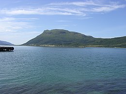
 View of the southern part of Hugla | |
 | |
 Hugla Location of the island  Hugla Hugla (Norway) | |
| Geography | |
|---|---|
| Location | Nordland, Norway |
| Coordinates | 66.1873°N 12.9177°E |
| Area | 17.9 km2 (6.9 sq mi) |
| Length | 7 km (4.3 mi) |
| Width | 4.5 km (2.8 mi) |
| Highest elevation | 629 m (2064 ft) |
| Highest point | Huggeltind |
| Administration | |
Norway | |
| County | Nordland |
| Municipality | Nesna Municipality |
See also
References
- Store norske leksikon. "Hugla" (in Norwegian). Retrieved 2012-01-20.
На других языках
[de] Hugla
Hugla ist eine norwegische Insel, die am nördlichen Ende der Mündung des Ranfjordes liegt. Die Insel gehört zur Kommune Nesna in der norwegischen Fylke Nordland.- [en] Hugla
Текст в блоке "Читать" взят с сайта "Википедия" и доступен по лицензии Creative Commons Attribution-ShareAlike; в отдельных случаях могут действовать дополнительные условия.
Другой контент может иметь иную лицензию. Перед использованием материалов сайта WikiSort.org внимательно изучите правила лицензирования конкретных элементов наполнения сайта.
Другой контент может иметь иную лицензию. Перед использованием материалов сайта WikiSort.org внимательно изучите правила лицензирования конкретных элементов наполнения сайта.
2019-2025
WikiSort.org - проект по пересортировке и дополнению контента Википедии
WikiSort.org - проект по пересортировке и дополнению контента Википедии