geo.wikisort.org - Insel
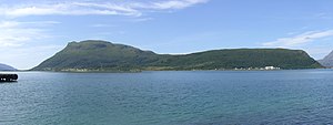
Hugla ist eine norwegische Insel, die am nördlichen Ende der Mündung des Ranfjordes liegt. Die Insel gehört zur Kommune Nesna in der norwegischen Fylke Nordland.
| Hugla | |
|---|---|
 | |
| Gewässer | Europäisches Nordmeer |
| Geographische Lage | 66° 11′ 12″ N, 12° 55′ 10″ O |
 | |
| Fläche | 17,9 km² |
| Höchste Erhebung | Hugltinden 624 m |
| Einwohner | 105 5,9 Einw./km² |
Der Inselname wurde bereits in der Snorra-Edda erwähnt und hängt mit dem Begriff haug zusammen, der mit dem deutschen Hügel verwandt ist.[1]
Der Großteil der Besiedlung liegt im Osten der Insel, die mit einer Autofähre mit Nesna verbunden ist.[1] Die Insel hat eine Schule und einen kleinen Laden.
Weblinks
Commons: Hugla – Sammlung von Bildern, Videos und Audiodateien
- Huglen Webportal über die Insel (norwegisch)
Einzelnachweise
- Store Norske Leksikon: Hugla, abgerufen am 13. September 2010 (norwegisch)
На других языках
- [de] Hugla
[en] Hugla
Hugla is an island in the municipality of Nesna in Nordland county, Norway. The 17.9-square-kilometre (6.9 sq mi) island lies south of the islands of Tomma and Handnesøya, west of the mainland of Nesna, east of the island of Løkta, and north of the Ranfjorden. The residents of the island live mostly on the eastern coast, across the fjord from the village of Nesna.[1]Текст в блоке "Читать" взят с сайта "Википедия" и доступен по лицензии Creative Commons Attribution-ShareAlike; в отдельных случаях могут действовать дополнительные условия.
Другой контент может иметь иную лицензию. Перед использованием материалов сайта WikiSort.org внимательно изучите правила лицензирования конкретных элементов наполнения сайта.
Другой контент может иметь иную лицензию. Перед использованием материалов сайта WikiSort.org внимательно изучите правила лицензирования конкретных элементов наполнения сайта.
2019-2025
WikiSort.org - проект по пересортировке и дополнению контента Википедии
WikiSort.org - проект по пересортировке и дополнению контента Википедии