geo.wikisort.org - Island
Hateruma (波照間島; Hateruma-jima; Yaeyama: Patirooma, Hateruma dialect: Besїma "our island", Okinawan: Hatiruma, Northern Ryukyuan: は°たら Patara) is an island in the Yaeyama District of Okinawa Prefecture, Japan.[1] Part of the town Taketomi, it is the southernmost inhabited island in Japan at 24°2’25" north latitude, 123°47’16" east longitude. Hateruma is one of the Yaeyama Islands, and is located 24 kilometres (15 mi) south of Iriomote-jima, the largest of the island group.[2]
 Aerial view of Hateruma | |
 Hateruma 波照間島 | |
| Geography | |
| Archipelago | Yaeyama Islands |
| Adjacent bodies of water | Pacific Ocean |
| Area | 12.7 km2 (4.9 sq mi) |
| Coastline | 14.8 km (9.2 mi) |
| Highest elevation | 59.5 m (195.2 ft) |
| Administration | |
Japan | |
| Prefectures | Okinawa Prefecture |
| District | Yaeyama |
| Town | Taketomi |
| Demographics | |
| Ethnic groups | Ryukyuan, Japanese |
Hateruma, which is composed of corals, has 12.7 km2 of area and approximately 600 inhabitants.
The primary products of the island include sugarcane, pineapple, refined sugar, and Awanami, a highly prized type of the alcoholic beverage awamori.[1] Its southern location makes it one of the few places in Japan where the Southern Cross can be observed.
Sights
Hateruma is visited by a comparatively high number of Japanese tourists from Ishigaki on day trips, as it boasts the southernmost tip of land of Japan. In addition, the southernmost school and the southernmost police station of Japan are tourist attractions. Further places of interest include:
- In the only village, several well-preserved old houses showing the traditional architecture with a hip roof, red tiles and a shisa statue on the top can be seen. Many old houses are still surrounded by a thick wall consisting of dark coral stones.
- In the village center, there is a memorial to Oyake Akahachi, a rebel who was born on Haterumajima around 1500. The memorial was erected on a platform of coral stones.
- One of the most interesting buildings on Haterumajima is the old watchtower Kodomori dating from the 17th century. It was used for observing the ships sailing to and from Ishigaki. As the top of the tower was one of the highest points of the flat island, it was used for smoke signals and for signal lights. A similar tower, which is called Puzumari, can be visited on the neighboring island Kuroshima.
- On the south coast, there is a memorial indicating the southernmost tip of land of Japan. The south coast is steep and the sea is very rough there.
- The north coast of Haterumajima is a favorite tourist destination, because of its fine sand.
Climate
Hateruma has a tropical rainforest climate (Af according to the Köppen climate classification), because all twelve months have a mean temperature of at least 18 °C (64 °F). The temperature is consistently warm year-round, with January, the coolest month, having a mean of 19.0 °C (66.2 °F) and an average low of 17.0 °C (62.6 °F). July is the warmest month, with a mean of 29.1 °C (84.4 °F) and an average high of 32.2 °C (90.0 °F). The highest temperature ever recorded was 35.7 °C (96.3 °F) in August and the lowest recorded temperature was 7.8 °C (46.0 °F) in March.
Hateruma receives 1,744.5 millimetres (68.68 in) of precipitation annually. Precipitation is abundant year-round, with every month receiving at least 100 millimetres (3.9 in) of rain. Typhoons often bring heavy rain, so Hateruma receives more precipitation at the peak of the typhoon season. September is the wettest month, receiving 214.6 millimetres (8.45 in) of rain on average. February is the driest month, receiving 101.4 millimetres (3.99 in) of rainfall. There are a similar amount of precipitation days each month, with April having the least with 8.3 and January having the most with 11.6 days. Hateruma receives 1965.8 hours of sunshine annually, with summer being the sunniest season and winter being the least sunny season.
| Climate data for Hateruma (1991−2020 normals, extremes 1979−present) | |||||||||||||
|---|---|---|---|---|---|---|---|---|---|---|---|---|---|
| Month | Jan | Feb | Mar | Apr | May | Jun | Jul | Aug | Sep | Oct | Nov | Dec | Year |
| Record high °C (°F) | 27.7 (81.9) |
28.5 (83.3) |
29.6 (85.3) |
31.3 (88.3) |
34.0 (93.2) |
34.7 (94.5) |
35.4 (95.7) |
35.7 (96.3) |
35.0 (95.0) |
32.6 (90.7) |
30.7 (87.3) |
29.7 (85.5) |
35.7 (96.3) |
| Average high °C (°F) | 21.5 (70.7) |
22.1 (71.8) |
23.8 (74.8) |
26.1 (79.0) |
28.6 (83.5) |
31.0 (87.8) |
32.2 (90.0) |
31.9 (89.4) |
30.7 (87.3) |
28.4 (83.1) |
26.0 (78.8) |
22.9 (73.2) |
27.1 (80.8) |
| Daily mean °C (°F) | 19.0 (66.2) |
19.5 (67.1) |
20.9 (69.6) |
23.2 (73.8) |
25.7 (78.3) |
28.1 (82.6) |
29.1 (84.4) |
28.8 (83.8) |
27.7 (81.9) |
25.7 (78.3) |
23.5 (74.3) |
20.5 (68.9) |
24.3 (75.8) |
| Average low °C (°F) | 17.0 (62.6) |
17.4 (63.3) |
18.7 (65.7) |
21.0 (69.8) |
23.5 (74.3) |
26.0 (78.8) |
26.8 (80.2) |
26.5 (79.7) |
25.5 (77.9) |
23.9 (75.0) |
21.7 (71.1) |
18.7 (65.7) |
22.2 (72.0) |
| Record low °C (°F) | 8.0 (46.4) |
10.4 (50.7) |
7.8 (46.0) |
13.0 (55.4) |
16.7 (62.1) |
17.8 (64.0) |
22.0 (71.6) |
22.5 (72.5) |
20.2 (68.4) |
15.6 (60.1) |
14.3 (57.7) |
10.3 (50.5) |
7.8 (46.0) |
| Average precipitation mm (inches) | 119.6 (4.71) |
101.4 (3.99) |
114.9 (4.52) |
131.7 (5.19) |
170.5 (6.71) |
147.7 (5.81) |
112.8 (4.44) |
180.0 (7.09) |
214.6 (8.45) |
162.6 (6.40) |
147.2 (5.80) |
128.0 (5.04) |
1,744.5 (68.68) |
| Average precipitation days (≥ 1.0 mm) | 11.6 | 9.4 | 9.5 | 8.3 | 9.4 | 9.2 | 9.1 | 11.0 | 10.9 | 9.7 | 10.3 | 11.5 | 119.9 |
| Mean monthly sunshine hours | 94.3 | 97.8 | 128.1 | 143.8 | 174.9 | 221.4 | 261.2 | 238.5 | 199.1 | 179.7 | 127.3 | 99.8 | 1,965.8 |
| Source: JMA[3][4] | |||||||||||||
Infrastructure
Hateruma Airport is located on the island, but is not currently served by any commercial flights. Haterujima is easily accessible by ferry from Ishigaki several times a day. There are several guest houses and some shops and restaurants on the island. Bikes are for hire at the harbor.
Education

The Taketomi town authorities maintain a single combined elementary and junior high school on the island: Hateruma Elementary and Junior High School (竹富町立波照間小中学校).[5]
For public senior high school students may attend schools of the Okinawa Prefectural Board of Education.
Gallery
 Monument at the southernmost point of Japan open to the public
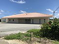
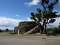 Kodomori Tower
 South Coast
 Akahachi Memorial
 Village center
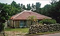 Traditional architecture
 The southernmost police station of Japan
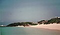 North Coast
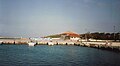 Harbour


See also
- Geography of Japan
- Japanese Archipelago
- List of extreme points of Japan
- Okinotorishima
- Paipatirōma-jima
References
- "波照間島" [Hateruma]. Dijitaru Daijisen (in Japanese). Tokyo: Shogakukan. 2013. OCLC 56431036. Archived from the original on 2007-08-25. Retrieved 2013-01-17.
- "波照間島" [Hateruma]. Nihon Daihyakka Zensho (Nipponika) (in Japanese). Tokyo: Shogakukan. 2013. OCLC 153301537. Archived from the original on 2007-08-25. Retrieved 2013-01-17.
- 観測史上1~10位の値(年間を通じての値). JMA. Retrieved February 23, 2022.
- 気象庁 / 平年値(年・月ごとの値). JMA. Retrieved February 23, 2022.
- "小中学校・小学校・中学校". Taketomi Town. Retrieved 2021-07-14.
Bibliography
- Yamakei: Ryukyu Nansei Shoto, p. 120-121. Tokio 2003. ISBN 4-635-01718-4
External links
- 美しき島々 ~波照間島~ (Japanese page)
- 美ら島物語 波照間島情報 Archived 2012-05-12 at WebCite (Japanese page)
| Wikimedia Commons has media related to Haterumajima. |
Authority control | |
|---|---|
| General | |
| National libraries | |
На других языках
[de] Hateruma
Hateruma (jap. 波照間島, Hateruma-jima) ist mit weniger als 540 Einwohnern in 261 Haushalten (Stand: 31. März 2011) die südlichste bewohnte Insel Japans. Ihre Fläche beträgt 12,77 km²[1] und die höchste Erhebung beträgt 59,5 m.[2]- [en] Hateruma
[fr] Hateruma-jima
Hateruma (波照間島, Hateruma-jima?) est une île de l'archipel des Îles Yaéyama au sud-ouest du Japon, faisant partie de l'archipel Sakishima, avec les îles Miyako à l'est et les îles Senkaku plus au nord, et donc des îles Ryūkyū.[ru] Хатерума
Хатеру́ма[1] (яп. 波照間島 хатэрума-дзима) — небольшой остров в островной группе Яэяма островов Сакисима архипелага Рюкю. Административно относится к округу Такетоми уезда Яэяма префектуры Окинава, Япония. Является самым южным из заселённых островов Японии, в честь чего здесь установлен монумент.Другой контент может иметь иную лицензию. Перед использованием материалов сайта WikiSort.org внимательно изучите правила лицензирования конкретных элементов наполнения сайта.
WikiSort.org - проект по пересортировке и дополнению контента Википедии