geo.wikisort.org - Island
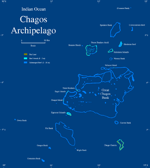
The Great Chagos Bank, in the Chagos Archipelago, about 500 km (310 mi) south of Maldives, is the largest atoll structure in the world, with a total area of 12,642 km2 (4,881 sq mi).[1] The atoll is administered by the United Kingdom through the British Indian Ocean Territory (BIOT).

Islands
Despite its enormous size, the Great Chagos Bank is largely a submarine structure. There are only four emerging reefs, mostly located on the western rim of the atoll, except for lonely Nelson Island, which lies wholly isolated in the middle of the northern fringe. These reefs have eight individual low and sandy islands, with a total land area of about 5.6 km2 (2.2 sq mi). All islands and their surrounding waters are a Strict Nature Reserve since 1998.[2] The total length of the eastern and southern expanses of the bank, as well as the reefs in its central area are wholly submerged.
The islands of the Great Chagos Bank, starting clockwise from the south, are:
- Danger Island (slightly more than 2 km (1.2 mi) long from North to South, by 1 km (0.62 mi) wide, land area 0.66 km2 (0.25 sq mi), vegetated with palm trees up to 12 m (39 ft) high.
- Eagle Islands
- Île Aigle (Eagle Island, vegetated with high coconut trees, land area 2.45 km2 (0.95 sq mi)
- Sea Cow Island (Île Vache Marine), vegetated with trees, land area 18 hectares (44 acres).
- Three Brothers (Trois Frères) and Resurgent Islands, vegetated with high coconut trees, land area 0.4 km2 (0.15 sq mi).
- Île du Sud (South Island, largest of the group), 23 ha (57 acres)
- Île du Milieu (Middle Island), 8 ha (20 acres)
- Resurgent Island (unvegetated), 1 ha (2.5 acres)
- Île du Nord (North Island), 6 ha (15 acres)
- Nelson Island (2 km (1.2 mi) long from East to West, up to 0.41 km (0.25 mi) wide, land area 0.4 km2 (0.15 sq mi), with 3 m (9.8 ft) high, bushy vegetation.
Cartography of the submerged reefs
The Great Chagos Bank was surveyed for the first time by Commander Robert Moresby of the Indian Navy in 1837; all other maps that would be drawn for over a century and a half were based on his chart.[3] Although the charts of atolls made up of mostly emerged reefs, like Peros Banhos and Diego Garcia, were relatively accurate, the cartography of the vast sunken reefs forming the Great Chagos Bank proved quite a challenge. The real shape of these sunken reefs was known only when satellite imagery became available in the latter part of the 20th century.
Moresby's original hydrographic drawings were somewhat at variance with the true shape of the submerged reef, especially in areas where there were no emerging islands close by, like in the South east of the bank. The outlines of the first hydrographic surveys were marked in the 1980s navigational maps of the Chagos with a dotted line and the legend "existence doubtful" until the 1998 edition.[4]
See also
- Chagos Archipelago
- Chagos Marine Protected Area
- Diego Garcia
References
- Purdy, Edward G., ed. (2001). "Origin of atoll lagoons" (PDF). GSA Bulletin. 113 (7): 837. doi:10.1130/0016-7606(2001)113<0837:ooal>2.0.co;2. Retrieved 14 July 2018.
- "[Nature Conservation of the] British Indian Ocean Territory" (PDF). Department for Environment, Food & Rural Affairs. 22 December 2004. Retrieved 14 July 2018.
- University of Washington Library - Great Chagos Bank 1890 Archived 2012-11-05 at the Wayback Machine
- British Admiralty nautical chart 11000030 - 3 Chagos Archipelago, Scale 1:360 000
External links
- Oceandots - Great Chagos Bank at the Wayback Machine (archived December 23, 2010)
- Geochronology of Basement Rocks from the Mascarene Plateau, the Chagos Bank and the Maldives Ridge
На других языках
[de] Great Chagos Bank
Die Great Chagos Bank (dt. etwa Große Chagosbank) liegt genau in der Mitte des Chagos-Archipels. Sie liegt ungefähr 500 km südlich der Malediven und ist mit 12.642 km² die größte zusammenhängende Atollgruppe weltweit. Die Lagune ist durchschnittlich 75 Meter tief; die größte Tiefe beträgt 90 Meter.[1]- [en] Great Chagos Bank
[fr] Banc Great Chagos
Le banc Great Chagos, en anglais Great Chagos Bank, est un atoll inhabité de l'archipel des Chagos, dans le territoire britannique de l'océan Indien, un territoire britannique d'outre-mer[1].[it] Banco delle Chagos
Il banco delle Chagos (in inglese Great Chagos Bank), nell'arcipelago delle isole Chagos, circa 500 km a sud delle Maldive, è la più grande struttura ad atollo del mondo, con un'area totale di circa 12.642 km2. L'atollo è amministrato dal Regno Unito all'interno del territorio britannico d'oltremare chiamato territorio britannico dell'Oceano Indiano.Другой контент может иметь иную лицензию. Перед использованием материалов сайта WikiSort.org внимательно изучите правила лицензирования конкретных элементов наполнения сайта.
WikiSort.org - проект по пересортировке и дополнению контента Википедии