geo.wikisort.org - Island
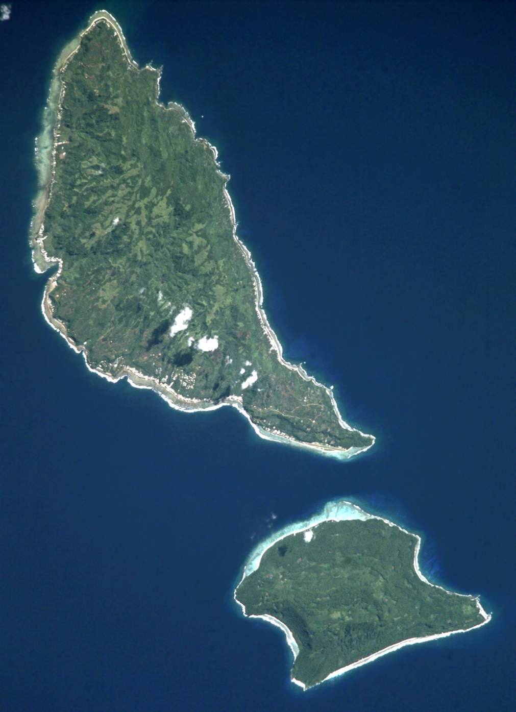
Futuna (/fuːˈtuːnə/; French: [fu.tu.na]) is an island in the Pacific Ocean occupying area of 80 km2 (30 sq mi) with a population of 10,912. It belongs to the French overseas collectivity (collectivité d'outre-mer, or COM) of Wallis and Futuna. It is one of the Hoorn Islands or Îles Horne; nearby Alofi is the other. They are both remnants of the same ancient, extinct volcano, now bordered with a fringing reef. Futuna has a maximum elevation of 500 m (1,600 ft).
This article has multiple issues. Please help improve it or discuss these issues on the talk page. (Learn how and when to remove these template messages)
|

with Futuna Island in the northwest

Futuna is where Pierre Chanel was martyred in 1841, becoming Polynesia's only Catholic saint. The cathedral of Poi now stands on the site where he was martyred.
Futuna takes its name from an endonym derived from the local futu, meaning fish-poison tree.
Geography
The population was 3,225 (as of the 2018 census); 1,950 reside in Alo district and 1,275 in Sigave. Futuna's highest point is Mont Puke at 524 m (1,719 ft) above sea level, and the island has an area of 83 km2 (32 sq mi), with 53 km2 (20 sq mi) in Sigave and 30 km2 (12 sq mi) in Alo.
Climate
Futuna (Maopoopo weather station) has a tropical rainforest climate (Köppen climate classification Af). The average annual temperature in Maopoopo is 27.5 °C (81.5 °F). The average annual rainfall is 3,333.6 mm (131.24 in) with December as the wettest month. The temperatures are highest on average in February, at around 28.2 °C (82.8 °F), and lowest in August, at around 26.5 °C (79.7 °F). The highest temperature ever recorded in Maopoopo was 35.8 °C (96.4 °F) on 10 January 2016; the coldest temperature ever recorded was 19.0 °C (66.2 °F) on 12 August 1980.
| Climate data for Futuna (Maopoopo weather station, 1991–2020 averages, extremes 1979−present) | |||||||||||||
|---|---|---|---|---|---|---|---|---|---|---|---|---|---|
| Month | Jan | Feb | Mar | Apr | May | Jun | Jul | Aug | Sep | Oct | Nov | Dec | Year |
| Record high °C (°F) | 35.8 (96.4) |
35.0 (95.0) |
34.2 (93.6) |
33.9 (93.0) |
33.4 (92.1) |
32.6 (90.7) |
31.9 (89.4) |
32.3 (90.1) |
33.0 (91.4) |
33.9 (93.0) |
33.8 (92.8) |
34.6 (94.3) |
35.8 (96.4) |
| Average high °C (°F) | 31.2 (88.2) |
31.2 (88.2) |
31.1 (88.0) |
30.7 (87.3) |
29.9 (85.8) |
29.1 (84.4) |
28.6 (83.5) |
28.7 (83.7) |
29.2 (84.6) |
29.7 (85.5) |
30.4 (86.7) |
30.9 (87.6) |
30.1 (86.2) |
| Daily mean °C (°F) | 28.2 (82.8) |
28.2 (82.8) |
28.2 (82.8) |
27.9 (82.2) |
27.4 (81.3) |
27.0 (80.6) |
26.5 (79.7) |
26.5 (79.7) |
26.8 (80.2) |
27.1 (80.8) |
27.6 (81.7) |
28.0 (82.4) |
27.5 (81.5) |
| Average low °C (°F) | 25.2 (77.4) |
25.2 (77.4) |
25.2 (77.4) |
25.2 (77.4) |
24.9 (76.8) |
24.8 (76.6) |
24.3 (75.7) |
24.2 (75.6) |
24.4 (75.9) |
24.5 (76.1) |
24.8 (76.6) |
25.1 (77.2) |
24.8 (76.6) |
| Record low °C (°F) | 21.3 (70.3) |
21.9 (71.4) |
21.2 (70.2) |
21.8 (71.2) |
20.9 (69.6) |
21.5 (70.7) |
20.1 (68.2) |
19.0 (66.2) |
19.5 (67.1) |
20.7 (69.3) |
20.9 (69.6) |
20.6 (69.1) |
19.0 (66.2) |
| Average precipitation mm (inches) | 329.2 (12.96) |
354.1 (13.94) |
341.3 (13.44) |
308.3 (12.14) |
262.6 (10.34) |
185.6 (7.31) |
175.1 (6.89) |
181.8 (7.16) |
225.6 (8.88) |
244.2 (9.61) |
324.1 (12.76) |
401.7 (15.81) |
3,333.6 (131.24) |
| Average precipitation days (≥ 1.0 mm) | 19.7 | 18.7 | 20.5 | 19.1 | 16.2 | 14.7 | 13.9 | 14.5 | 15.2 | 16.7 | 18.2 | 20.1 | 207.6 |
| Mean monthly sunshine hours | 175.7 | 160.2 | — | 154.4 | — | 120.1 | 121.3 | 125.5 | 135.0 | 154.9 | 165.8 | 180.3 | — |
| Source: Météo France[1] | |||||||||||||
History
Futuna and Alofi were put on the European maps in 1616 by Willem Schouten and Jacob Le Maire during their famous circumnavigation of the globe on the ship Eendracht. After sailing to Niuafoʻou, they suddenly changed course from west to northwest and so stumbled on these two islands. They called it Hoorn Eylanden, after the city of Hoorn, Schouten's birthplace. This became Horne in French and English. They found a beautiful bay, a natural harbour along the southwest coast of Futuna, which they named after their ship as Eendrachts baai (Unity Bay). It is thought that their landing place was the site of the Anse de Sigave near what is today called Leava.
Schouten and Le Maire had learned from earlier experiences how to approach islanders successfully. Upon landing, they went ashore, and, when approached by some of the natives, they made a show of force. This opened the way a peaceful barter, with the natives offering coconuts, yams and hogs in exchange for the sailors’ iron nails, beads and knives. They went on to get fresh water and meet the king, who told his subjects that their guests were not to be disturbed by petty thieving. In this amiable way, the Dutch sailors were able to replenish their stocks. A few days after they arrived, the king of the other island, Alofi, came to visit, bringing with him 300 men. The two kings were extremely courteous to each other, and a great feast was prepared. A kava ceremony and ʻumu were organised. Schouten and Le Maire were probably the first Europeans ever to witness these ceremonials, and the description they gave still rings familiar today.
Not having been bothered by thieving or hostilities, Schouten and Le Maire were able to study Futuna a more thoroughly than had been possible for them in the case of the Niua islands. They did not visit Alofi. Their description of the islanders’ appearance and behavior was not flattering. Although they praise the men for being well proportioned, they found the women ugly and ill-shaped, with breasts hanging down to their bellies like empty satchels. The people were said to all go naked, and to copulate in public, even in front of their king.
In the 19th century, whaling ships from the United States and elsewhere called at Futuna for water, wood and food. The first one known to have called was the Independence in 1827.[2]
Culture
Two kings, elected from the local nobility every few years, rule the population in conjunction with French authorities. They are the king of Sigave, the western province, and the king of Alo, the eastern province including Alofi. Except for Poi all villages are along the southwest coast, and they are from west to east: Toloke, Fiua, Vaisei, Nuku, and Leava (capital with the wharf) in Sigave, and Taoa, Malaʻe, Ono, Kolia and Vele (at the airstrip) in Alo.
99% of the population of Wallis and Futuna are Catholic.[3] Although the island is closer to Tonga and farther from Samoa than ʻUvea, the vernacular and culture are more Samoan. The languages spoken are Futunan and French.
Education
There are six primary schools on Futuna.[4] The island also has two junior high schools (collèges): Fiua de Sigave and Sisia d'Ono. Residents are served by a senior high school/sixth-form college, Lycée d'Etat de Wallis et Futuna, on Wallis.[5]
See also
- Pointe Vele Airport
- Peter Chanel
References
- "Climate of Maopoopo 1991-2020" (PDF) (in French). Météo-France. Retrieved August 26, 2022.
- Robert Langdon (ed.) Where the whalers went: an index to the Pacific ports and islands visited by American whalers (and some other ships) in the 19th century, Canberra, Pacific Manuscripts Bureau, 1984, p.32.
- "Wallis and Futuna". CIA World Factbook. Retrieved 18 June 2022.
- "LIVRET D'ACCUEIL Wallis et Futuna." Wallis and Futuna. p. 22 (22/28). Retrieved on September 14, 2016.
- "Cartographie des établissements du second degré." Wallis and Futuna. June 24, 2016. Retrieved on September 14, 2016.
References
- Cartes institut géographique national (4902F)
- https://www.worldometers.info/world-population/wallis-and-futuna-islands-population/
- Robert Kerr (1824): Voyage round the world, in 1615-1617, by William Cornelison Schouten and Jacques le Maire, going round Cape Horn. The comments of the editor to the original ship's journals are completely wrong, however.
- Percy Smith (1892): "Futuna; or, Horne Island and its People", Journal of the Polynesian Society, vol.1, pp. 33–52
Wallis and Futuna articles | |||
|---|---|---|---|
| |||
| Islands |  | ||
| Chiefdoms |
| ||
| Geography |
| ||
| Politics |
| ||
| Economy |
| ||
| Culture | |||
| |||
Authority control | |
|---|---|
| General |
|
| National libraries | |
На других языках
[de] Futuna (Wallis und Futuna)
Futuna ist eine 46 km² große, nordöstlich von Fidschi im Südpazifik gelegene Insel vulkanischen Ursprungs, die zum französischen Übersee-Territorium Wallis und Futuna gehört. Die Insel bildet zusammen mit der südöstlich gelegenen kleineren Nachbarinsel Alofi und einigen vorgelagerten Riffen den Archipel der Horn-Inseln.- [en] Futuna (Wallis and Futuna)
[es] Futuna
Futuna es una isla en el océano Pacífico que pertenece a la colectividad francesa de ultramar (colectividad d'outre-mer o COM) de Wallis y Futuna. Es una de las islas Hoorn o Horne Îles, cerca de Alofi otra isla que pertenece al mismo archipiélago. Ambas son un remanente de un volcán extinto, ahora bordeadas por una franja arrecifal.[fr] Futuna
Futuna (/fu.tu.na/) est une île située en Polynésie occidentale, au nord-est des Îles Fidji, au nord-ouest des Tonga et à l'ouest des îles Samoa, formant avec Alofi au sud-est l'archipel des îles Horn. Futuna est divisée en deux royaumes coutumiers : Alo au sud-est et Sigave au nord-ouest. Futuna fait partie de la collectivité d'outre-mer française de Wallis-et-Futuna.[it] Futuna (Wallis e Futuna)
Futuna è un'isola dell'oceano Pacifico appartenente al territorio francese di Wallis e Futuna. Fa parte delle isole Hoorn (Îles Horne), vicino all'isola di Alofi, tra le altre. Sono entrambe i resti di un antico vulcano.[ru] Футуна (Уоллис и Футуна)
Футуна (фр. Futuna) — остров в юго-западной части Тихого океана, являющийся частью заморской общины Франции Уоллис и Футуна.Другой контент может иметь иную лицензию. Перед использованием материалов сайта WikiSort.org внимательно изучите правила лицензирования конкретных элементов наполнения сайта.
WikiSort.org - проект по пересортировке и дополнению контента Википедии