geo.wikisort.org - Island
Ella Island, or Ella Ø, is an island in eastern Greenland, within Northeast Greenland National Park.
 Southwestern side. Onlap of devonian sandstone (right) on folded cambrian to ordovician rocks (left). | |
 Ella Island | |
| Geography | |
| Location | Greenland Sea |
| Coordinates | 72°51′N 25°00′W |
| Administration | |
Greenland | |
| Zone | Northeast Greenland National Park |
| Demographics | |
| Population | 0 |
Geography
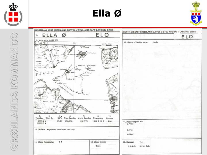
Ella Island is located at the mouth of Kempe Fjord in the northern end of King Oscar Fjord. To the east lie larger Traill Island and Geographical Society Island. Off its northern end lie Maria Island and Ruth Island.[1]
The island has an area of 143.6 km2 and a shoreline of 59.6 kilometres.[2] Ella Island is separated from the western shore of the fjord by the Narwhal Sound.

History
Lauge Koch had a cabin on the northern side of the island named Eagle's nest. The botanist Thorvald Sørensen spent the years 1931-1935 here. His observations formed the basis for his doctoral thesis in 1941.
During World War II, US forces had an installation on the island called Bluie East Four.[3] The Sirius Sledge Patrol maintains a small base on the island which is staffed only in summer.[4][5]
In 1971 a meteorite was found on Ella Island,[6] classified as a L-6 chondrite.
See also
References
- "Kempes Fjord". Mapcarta. Retrieved 5 August 2019.
- UNEP
- Greenland Stations Archived 2007-11-23 at the Wayback Machine
- Palle Norrit. "The Sirius Sledge Patrol". Archived from the original on 2011-04-21. Retrieved 2010-07-26.
- "Organisation" (in Danish). Grønlands Kommando. Archived from the original on 2010-11-14. Retrieved 2010-07-26.
- 1975Metic..10 1C Page 1
Weblinks
- Photograph of Sirius summer station
- Map of Ella Island showing location of station
Abandoned sites in Greenland | ||||||||||||||
|---|---|---|---|---|---|---|---|---|---|---|---|---|---|---|
|
|  | ||||||||||||
|
| |||||||||||||
| ||||||||||||||
|
| |||||||||||||
|
| |||||||||||||
|
| |||||||||||||
| Polar exploration |
| |||||||||||||
| Paleo-Eskimo |
| |||||||||||||
This Greenland location article is a stub. You can help Wikipedia by expanding it. |
На других языках
[de] Ella Ø
Ella Ø (deutsch Ella-Insel) ist eine grönländische Insel im Nordost-Grönland-Nationalpark.- [en] Ella Island
[fr] Île Ella
L'Île Ella est une île côtière du Groenland où s'entraîne l'armée du Canada pendant 2 mois d'été au secourisme[réf. souhaitée].[it] Ella Ø
Ella Ø è un'isola disabitata della Groenlandia di 144 km². Si trova a 72°51'N 25°02'O; è situato nel Parco nazionale della Groenlandia nordorientale, fuori da qualsiasi comune.[ru] Элла (остров)
Элла (дат. Ella Ø) — остров к востоку от Гренландии, в устье фьорда Кемпе на северной оконечности фьорда Короля Оскара. Остров входит в Северо-восточный гренландский национальный парк. Назван Альфредом Габриелем Натгорстом в ходе экспедиции 1899 года в честь его жены Эми Рафаелы (кратко Элла) Виндаль (1858—1936).Другой контент может иметь иную лицензию. Перед использованием материалов сайта WikiSort.org внимательно изучите правила лицензирования конкретных элементов наполнения сайта.
WikiSort.org - проект по пересортировке и дополнению контента Википедии