geo.wikisort.org - Island
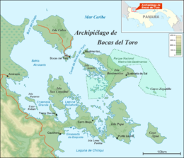
Cristóbal Island (in Spanish: Isla San Cristóbal, or Saint Christopher's Island) is a mostly deforested 37 km2 island located south of Isla Colón,[1] in the Bocas del Toro Archipelago, Panama. It is home to the indigenous Ngäbe or Guaymí people and a small number of expatriates.
Native name: Isla San Cristóbal | |
|---|---|
 Bocas del Toro Archipelago | |
| Geography | |
| Coordinates | 9°21′N 82°14′W |
| Archipelago | Bocas del Toro Archipelago |
| Area | 37 km2 (14 sq mi) |
| Highest elevation | 118 m (387 ft) |
| Highest point | Cerro Botabite II |
| Administration | |
Panama | |
| Province | Bocas del Toro |
| District | Bocas del Toro |
Laguna Bocatorito, also known as Dolphin Bay, lies on the east side of the island.
See also
References
- Jisel Perilla (2008), Frommer's Panama, Frommers, p. 282, ISBN 0-470-37183-8
| Islands |
|  |
|---|---|---|
| Protected areas |
| |
| Settlements |
| |
На других языках
- [en] Cristóbal Island
[fr] Île San Cristóbal (Panama)
L'Île San Cristóbal (en espagnol : Isla de San Cristóbal) est une île du Panama située dans la baie d'Almirante appartenant administrativement à la province de Bocas del Toro.Текст в блоке "Читать" взят с сайта "Википедия" и доступен по лицензии Creative Commons Attribution-ShareAlike; в отдельных случаях могут действовать дополнительные условия.
Другой контент может иметь иную лицензию. Перед использованием материалов сайта WikiSort.org внимательно изучите правила лицензирования конкретных элементов наполнения сайта.
Другой контент может иметь иную лицензию. Перед использованием материалов сайта WikiSort.org внимательно изучите правила лицензирования конкретных элементов наполнения сайта.
2019-2026
WikiSort.org - проект по пересортировке и дополнению контента Википедии
WikiSort.org - проект по пересортировке и дополнению контента Википедии