geo.wikisort.org - Island
Cominotto (Maltese: Kemmunett), sometimes referred to as Cominetto, is an uninhabited Mediterranean island off the northern coast of Malta.[1][2] Measuring only 0.25 square kilometres (0.10 sq mi) in area, it is the largest uninhabited island of Malta. Cominotto lies 100 metres (328 feet) to the north-west of Comino.
This article has multiple issues. Please help improve it or discuss these issues on the talk page. (Learn how and when to remove these template messages)
|
Native name: Kemmunett | |
|---|---|
 Cominotto as seen from Comino | |
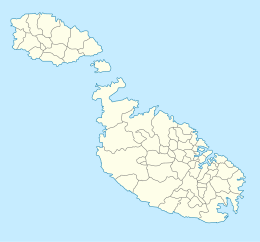
 Map of Comino. Cominotto is the small island on the left. | |
 Cominotto | |
| Geography | |
| Location | off Comino, between Gozo and Malta, south of Sicily, Mediterranean Sea |
| Coordinates | 36°00′49″N 14°19′11.9″E |
| Archipelago | Maltese Islands |
| Total islands | 7 |
| Major islands | 1 |
| Area | 0.25 km2 (0.097 sq mi) |
| Length | 396 m (1299 ft) |
| Width | 31.89–475.3 m (104.6–1,559.4 ft) |
| Coastline | 1.72 km (1.069 mi) |
| Highest elevation | 44 ft (13.4 m) |
| Administration | |
Malta | |
| Region | Gozo |
| Local council | Għajnsielem |
| Demographics | |
| Population | 0 |
Between Comino and Cominotto lie the transparent, cyan waters of the Blue Lagoon (Maltese: Bejn il-Kmiemen, literally "Between the Cominos"). Frequented by large numbers of tourists and tour boats daily, the Blue Lagoon makes it popular with divers and snorkelers.[3]
 The Blue Lagoon at sea level with Cominotto in the background
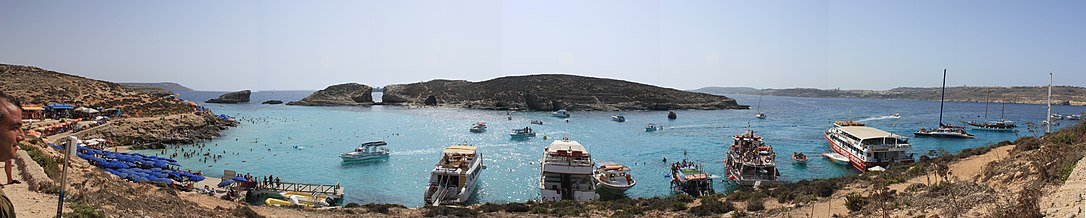 Cominotto and the Blue Lagoon


References
- "Comino & Cominotto in Gozo". www.responsibletravel.com. Retrieved 2022-09-05.
- "Attraction". Visit Malta. Retrieved 2022-09-05.
- "Sailing directions for the Mediterranean: France, west coast of Italy, Corsica, Sardinia and Sicily, including adjacent islands". 1958.
Wikimedia Commons has media related to Cominotto.
Islands of Malta | ||
|---|---|---|
| Inhabited | ||
| Uninhabited |
| |
This Malta location article is a stub. You can help Wikipedia by expanding it. |
На других языках
[de] Cominotto
Cominotto (maltesisch Kemmunett) ist ein unbewohnter Inselfelsen, der zu den Maltesischen Inseln zählt. Politisch gehört er zur Republik Malta. Seine Fläche beträgt nur 0,25 km². Er ist der Insel Comino an deren Westküste in einem Abstand von etwa 100 m vorgelagert.- [en] Cominotto
[es] Cominotto
Cominotto (en maltés Kemmunett), también conocida como Cominetto es un islote deshabitado del archipiélago de Malta, en el mar Mediterráneo, y pertenece a la República de Malta. Está situado en la costa norte de la isla de Malta, a 100 metros de la isla Comino. Tiene 0,25 km² de área.[fr] Cominotto
Cominotto, en maltais Kemmunett, parfois appelée Cominetto, est une petite île maltaise inhabitée d'une superficie de 0,25 km2. Cominotto se situe à cent mètres de distance à l'ouest de l'île de Comino dont elle est séparée par le détroit de Fliegu et dépend administrativement comme elle de la municipalité de Għajnsielem, dans le sud-est de l'île de Gozo.[it] Cominotto
Cominotto[1][2] (o anche Cominetto, in maltese Kemmunett) è un'isola disabitata dell'arcipelago delle Isole Calipsee, nel mare Mediterraneo. Misura 0,25 km². Cominotto si trova a una distanza di appena 100 metri dall'isola di Comino, nel canale di Gozo tra Malta e Gozo, e con essa circoscrive un piccolo canale che va a formare la Laguna blu (in maltese Bejn il-Kmiemen, letteralmente "Tra i due Comino").[ru] Коминотто
Коминотто[1][2] (мальт. Cominotto, мальт. Kemmunett) — крошечный необитаемый остров в Средиземном море, входящий в Мальтийский архипелаг и являющийся территорией государства Мальта. Расположен между островами Гоцо и Комино в 100 м к западу от последнего.Текст в блоке "Читать" взят с сайта "Википедия" и доступен по лицензии Creative Commons Attribution-ShareAlike; в отдельных случаях могут действовать дополнительные условия.
Другой контент может иметь иную лицензию. Перед использованием материалов сайта WikiSort.org внимательно изучите правила лицензирования конкретных элементов наполнения сайта.
Другой контент может иметь иную лицензию. Перед использованием материалов сайта WikiSort.org внимательно изучите правила лицензирования конкретных элементов наполнения сайта.
2019-2026
WikiSort.org - проект по пересортировке и дополнению контента Википедии
WikiSort.org - проект по пересортировке и дополнению контента Википедии