geo.wikisort.org - Island
Changhai County (Chinese: 长海县; pinyin: Chánghǎi Xiàn; lit. 'Long-Sea County') is a county under the administration of Dalian, Liaoning province, China. It consists of several islands in the Yellow Sea and is located offshore of the Liaodong Peninsula. There are 112 small islands and reefs in the county, traditionally called the Outer Long Mountains Island Chain (Chinese: 外长山群岛; pinyin: Wàichángshān Qúndǎo) and formerly sometimes called the Elliot Islands. The county has an area of 156.89 square kilometres (60.58 sq mi) and a permanent population as of 2010[update] of 77,951, making it Dalian's least populous county-level division,[2][3] and the county government is located in the Dongshan neighborhood of the town of Dachangshandao (Chinese: 大长山岛; lit. 'Great Long-Mountain Island').
This article may be expanded with text translated from the corresponding article in Chinese. (June 2020) Click [show] for important translation instructions.
|
Changhai
长海县 Elliot Islands | ||||||||||||||||||||||||||||||||||
|---|---|---|---|---|---|---|---|---|---|---|---|---|---|---|---|---|---|---|---|---|---|---|---|---|---|---|---|---|---|---|---|---|---|---|
County | ||||||||||||||||||||||||||||||||||
 Xiaoshuikou (小水口) Scenic Area in Xiaochangshan Island | ||||||||||||||||||||||||||||||||||
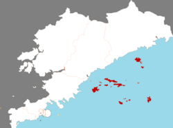 Location of Changhai County in Dalian | ||||||||||||||||||||||||||||||||||
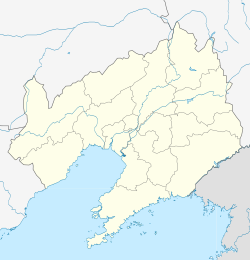 Changhai Location in Liaoning | ||||||||||||||||||||||||||||||||||
| Coordinates: 39°16′19″N 122°35′42″E[1] | ||||||||||||||||||||||||||||||||||
| Country | People's Republic of China | |||||||||||||||||||||||||||||||||
| Province | Liaoning | |||||||||||||||||||||||||||||||||
| Sub-provincial city | Dalian | |||||||||||||||||||||||||||||||||
| Seat | No. 1 Changhai Square, Dachangshandao (大长山岛镇长海广场1号) | |||||||||||||||||||||||||||||||||
| Area | ||||||||||||||||||||||||||||||||||
| • Total | 156.89 km2 (60.58 sq mi) | |||||||||||||||||||||||||||||||||
| Population (2010)[3] | ||||||||||||||||||||||||||||||||||
| • Total | 77,951 | |||||||||||||||||||||||||||||||||
| • Density | 500/km2 (1,300/sq mi) | |||||||||||||||||||||||||||||||||
| Time zone | UTC+8 (China Standard) | |||||||||||||||||||||||||||||||||
| Postal code | 116500 | |||||||||||||||||||||||||||||||||
| Dalian district map |
| |||||||||||||||||||||||||||||||||
| Division code | 210224 | |||||||||||||||||||||||||||||||||
| Website | www | |||||||||||||||||||||||||||||||||

Administrative divisions
There are 5 towns in the county.[4]
Towns:
- Dachangshandao (大长山岛镇)
- Zhangzidao (獐子岛镇)
- Guangludao (广鹿岛镇)
- Xiaochangshandao (小长山岛镇)
- Haiyangdao (海洋岛镇)
Climate
| Climate data for Changhai (1981−2010) | |||||||||||||
|---|---|---|---|---|---|---|---|---|---|---|---|---|---|
| Month | Jan | Feb | Mar | Apr | May | Jun | Jul | Aug | Sep | Oct | Nov | Dec | Year |
| Record high °C (°F) | 9.5 (49.1) |
11.3 (52.3) |
17.8 (64.0) |
22.3 (72.1) |
28.9 (84.0) |
34.5 (94.1) |
35.4 (95.7) |
33.4 (92.1) |
30.9 (87.6) |
26.4 (79.5) |
19.4 (66.9) |
13.0 (55.4) |
35.4 (95.7) |
| Average high °C (°F) | −0.7 (30.7) |
1.6 (34.9) |
6.3 (43.3) |
12.5 (54.5) |
17.9 (64.2) |
21.9 (71.4) |
25.1 (77.2) |
26.9 (80.4) |
24.1 (75.4) |
17.8 (64.0) |
9.5 (49.1) |
2.4 (36.3) |
13.8 (56.8) |
| Daily mean °C (°F) | −4.1 (24.6) |
−1.8 (28.8) |
2.8 (37.0) |
8.7 (47.7) |
14.0 (57.2) |
18.5 (65.3) |
22.3 (72.1) |
24.1 (75.4) |
21.0 (69.8) |
14.6 (58.3) |
6.2 (43.2) |
−0.9 (30.4) |
10.5 (50.8) |
| Average low °C (°F) | −6.8 (19.8) |
−4.5 (23.9) |
0.2 (32.4) |
5.8 (42.4) |
11.2 (52.2) |
16.0 (60.8) |
20.2 (68.4) |
21.9 (71.4) |
18.4 (65.1) |
11.8 (53.2) |
3.2 (37.8) |
−3.7 (25.3) |
7.8 (46.1) |
| Record low °C (°F) | −21.7 (−7.1) |
−18.1 (−0.6) |
−9.7 (14.5) |
−1.0 (30.2) |
4.6 (40.3) |
9.2 (48.6) |
14.7 (58.5) |
15.3 (59.5) |
9.4 (48.9) |
−0.4 (31.3) |
−12.5 (9.5) |
−15.6 (3.9) |
−21.7 (−7.1) |
| Average precipitation mm (inches) | 7.2 (0.28) |
7.2 (0.28) |
14.6 (0.57) |
29.0 (1.14) |
48.3 (1.90) |
82.4 (3.24) |
149.4 (5.88) |
138.8 (5.46) |
64.5 (2.54) |
28.4 (1.12) |
18.4 (0.72) |
7.7 (0.30) |
595.9 (23.43) |
| Average relative humidity (%) | 57 | 59 | 63 | 69 | 75 | 85 | 90 | 85 | 73 | 64 | 60 | 57 | 70 |
| Source: China Meteorological Data Service Center[5] | |||||||||||||
Transport
References
- Google (2014-07-02). "Changhai" (Map). Google Maps. Google. Retrieved 2014-07-02.
- Dalian Statistical Yearbook 2012 (《大连统计年鉴2012》). Accessed 8 July 2014.
- 2010 Census county-by-county statistics (《中国2010年人口普查分县资料》). Accessed 8 July 2014.
- 大连市-行政区划网. XZQH.
- 中国地面气候标准值月值(1981-2010) (in Simplified Chinese). China Meteorological Data Service Center. Retrieved 24 September 2022.
External links
Sub-provincial City of Dalian | ||
|---|---|---|
| Districts |  | |
| County-level cities | ||
| Counties | ||
| Landmarks | ||
| Culture & demographics | ||
| Education | ||
| Transport |
| |
^* Not a formal subdivision | ||
Authority control | |
|---|---|
| General | |
| National libraries | |
This Liaoning location article is a stub. You can help Wikipedia by expanding it. |
На других языках
- [en] Changhai County
[ru] Чанхай
Чанха́й (кит. упр. 长海, пиньинь Chánghǎi) — уезд города субпровинциального значения Далянь (КНР).Другой контент может иметь иную лицензию. Перед использованием материалов сайта WikiSort.org внимательно изучите правила лицензирования конкретных элементов наполнения сайта.
WikiSort.org - проект по пересортировке и дополнению контента Википедии