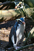
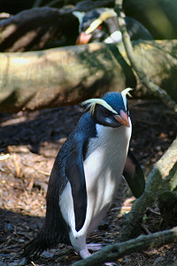
 Fiordland Penguin (Eudyptes pachyrhynchus)
 Yellowhead (Mohoua ochrocephala)
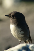 New Zealand South Island Robin (Petroica australis australis)
geo.wikisort.org - Island
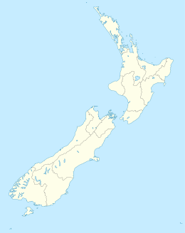
Breaksea Island is a rugged 1.6 km2 (1 sq mi) island in the southwest of New Zealand, and is part of Fiordland National Park. Its highest point is 350 m (1,148 ft) asl and it lies about 2 km (1.2 mi) from the mainland in the entrance to Te Puaitaha / Breaksea Sound, north of the much larger Resolution Island. It is covered in temperate rainforest and was the site of one of the first successful campaigns to eradicate rats from a sizeable island.
Kā Huruhuru-o-koekoeā | |
|---|---|
 Breaksea Island (center) - from the South-West. | |
 Breaksea Island | |
| Geography | |
| Location | Fiordland National Park |
| Coordinates | 45°34′45″S 166°38′14″E |
| Area | 1.56 km2 (0.60 sq mi)[1] |
| Highest elevation | 350 m (1150 ft) |
| Administration | |
New Zealand | |
| Demographics | |
| Population | 0 |
Rat eradication
The pioneering eradication of brown rats, using brodifacoum in poison baits, was carried out by the New Zealand Department of Conservation (DOC) in May and June 1988 following the success of a pilot campaign on the adjacent, and much smaller (9 ha or 22 acres), Hāwea Island in 1986. At the time, Breaksea was six times the size of the previous largest island on which rat eradication had been successful. Since then, DOC has overseen the eradication of a suite of introduced animals from several other islands, the largest being Campbell Island / Motu Ihupuku at 113 km2 (44 sq mi).[2][3]
Fauna
Fiordland crested penguins breed on Breaksea. Since rat eradication various threatened species of New Zealand's native fauna have been introduced, or reintroduced, there. These include the tieke (saddleback), mōhua (yellowhead), Fiordland skink and knobbled weevils.
Fauna of Fiordland Island


See also
- List of islands of New Zealand
- List of islands
- Desert island
References
- Taylor, R.H. & Thomas, B.W. (1989). "eradication of Norway Rats (Rattus norvegicus) from Hawea Island, Fiordland, using brodifacoum" (PDF). New Zealand Journal of Ecology. 12: 23–32.
- Wilson, Kerry-Jayne (2004). Flight of the Huia. Christchurch: Canterbury University Press. ISBN 978-0-908812-52-3.
- "Fiordland Islands restoration: project implementation". NZ Department of Conservation. Archived from the original on 20 February 2013. Retrieved 18 February 2010.
Notes
- "Tamatea/Dusky Sound convervation and restoration plan" (PDF). Department of Conservation. p. 20. Retrieved 17 October 2017.
- Taylor & Thomas (1989).
- Wilson (2004), pp.282-283.
External links
Wikimedia Commons has media related to Breaksea Island, New Zealand.
This Fiordland, New Zealand geography article is a stub. You can help Wikipedia by expanding it. |
На других языках
[de] Breaksea Island (Neuseeland)
Breaksea Island ist eine Insel an der Südwestküste der Südinsel von Neuseeland.[1]- [en] Breaksea Island (New Zealand)
Текст в блоке "Читать" взят с сайта "Википедия" и доступен по лицензии Creative Commons Attribution-ShareAlike; в отдельных случаях могут действовать дополнительные условия.
Другой контент может иметь иную лицензию. Перед использованием материалов сайта WikiSort.org внимательно изучите правила лицензирования конкретных элементов наполнения сайта.
Другой контент может иметь иную лицензию. Перед использованием материалов сайта WikiSort.org внимательно изучите правила лицензирования конкретных элементов наполнения сайта.
2019-2025
WikiSort.org - проект по пересортировке и дополнению контента Википедии
WikiSort.org - проект по пересортировке и дополнению контента Википедии