geo.wikisort.org - Island
Barren Island is an island located in the Andaman Sea. It is the only confirmed active volcano in the Indian subcontinent,[6][7][8][9] and the only active volcano along a chain of volcanoes from Sumatra to Myanmar.[10] It is a part of the Indian Union territory of Andaman and Nicobar Islands, and lies about 138 km (86 mi) northeast of the territory's capital, Port Blair.
 Barren Island Location of Barren Island  Barren Island Barren Island (Bay of Bengal) | |
| Geography | |
|---|---|
| Location | Bay of Bengal |
| Coordinates | 12.28°N 93.86°E |
| Archipelago | Andaman Islands |
| Adjacent bodies of water | Indian Ocean |
| Total islands | 1 |
| Major islands |
|
| Area | 8.34 km2 (3.22 sq mi)[1] |
| Length | 3.4 km (2.11 mi) |
| Width | 3.1 km (1.93 mi) |
| Coastline | 12.38 km (7.693 mi) |
| Highest elevation | 353 m (1158 ft)[2] |
| Administration | |
| District | North and Middle Andaman |
| Island group | Andaman Islands |
| Island sub-group | East Volcano Islands |
| Taluk | Rangat Taluk |
| Demographics | |
| Population | Uninhabited (2017) |
| Additional information | |
| Time zone |
|
| PIN | 744202[3] |
| Telephone code | 031927 [4] |
| ISO code | IN-AN-00[5] |
| Official website | andaman |
| Avg. summer temperature | 30.2 °C (86.4 °F) |
| Avg. winter temperature | 23.0 °C (73.4 °F) |
| Census Code | 35.639.0004 |
| Barren Volcano | |
|---|---|
 Barren Island erupting in 1995 | |
| Highest point | |
| Elevation | 353 m (1,158 ft) |
| Geography | |
| Location | Andaman Islands, India |
| Geology | |
| Mountain type | Stratovolcano with pyroclastic cones |
| Last eruption | 2021 |
History

The first recorded eruption of the volcano dates back to 1787. Since then, the volcano has erupted more than ten times, with the most recent one being in 2020 .[11] After the first recorded eruption in 1787, further eruptions were recorded in 1789, 1795, 1803–04, and 1852. After nearly one and a half century of dormancy, the island had another eruption in 1991 that lasted six months and caused considerable damage.[12][13]
The 1991 eruption was particularly harmful to the island's fauna. A team from the Geological Survey of India visited Barren Island on 8–9 April 1993 to assess the impact of the eruption on the distribution, habit, and abundance of animal species. The report found that the eruption had reduced the number of bird species and their population. The team only observed 6 of the 16 known species of birds on the island. The Pied Imperial Pigeon (Ducula bicolor) was the most abundant among the 6 species observed. In a survey conducted at night, the team spotted one rat species (Rattus rattus) and 51 species of insects from eight orders. The report also noted that the volcano was still emitting gas at the time.[10] There were eruptions in 1994–95 and 2005–07, the latter considered to be linked to the 2004 Indian Ocean earthquake.[12] A lighthouse that was established in 1993 was destroyed by the recent eruptions.[14]
A team from the National Institute of Oceanography spotted the volcano erupting on 23 January 2017. Abhay Mudholkar, the head of the team, said, "The volcano is erupting in small episodes of about five to ten minutes. During the day, only ash clouds were observed. However, after sundown, red lava fountains were spewing from the crater into the atmosphere and hot lava flowed streaming down its slopes."[15][16][17]
Based on Argon-argon dating of samples from Barren Island, it is now established that the oldest subaerial lava flows of the volcano are 1.6 million years old and the volcano is located on an oceanic crust which is roughly 106 million years old.[18] All recorded eruptions lie on the low end of the Volcanic Explosivity Index. The 2017 eruption was recorded as a 2 on the index.[10]
Geography
This volcanic island stands in the midst of a volcanic belt on the edge of the Indian and Burmese tectonic plates. Narcondam Island is a dormant volcano in the area, apart from volcanic seamounts like Alcock and Sewell. All the historical and recent eruptions (1789 and after) are confined within and around an active polygenetic cinder cone in a 2 km (1.2 mi) wide caldera that was formed by the Pleistocene collapse of a primitive cone of a stratovolcano. The remnant of the primitive volcanic cone forms a precipitous cliff around the island (commonly referred to as caldera wall), with a break towards the west. The highest elevation on the island is 353 m (1,158 ft), with most of the primitive volcano underwater (standing on the seafloor 2,250 metres (7,380 ft) below sea level). The island is 3 km (1.9 mi) in diameter, with a total surface area of 8.34 km2 (3.22 sq mi).[19]
Biodiversity
True to its name, it has large areas of barren landscape.[10] It is uninhabited by humans, though it has a small population of goats.[20] Also birds, bats like flying foxes and a few rodent species such as rats are known to survive the harsh conditions.[21]
Tourist attractions
The waters surrounding Barren Island are reputed to be among the world's top scuba diving destinations. Major attractions here are the crystal clear visibility, Manta Rays, interesting basalt formations, topography of past lava flows and fast growing coral gardens. This dive destination is remote but can be accessed by either a live aboard ship or with scuba-operators based at Swaraj Island.[22][23]
Administration
It belongs to the North and Middle Andaman administrative district, part of the Indian union territory of Andaman and Nicobar Islands.[24]
Demographics
The island is uninhabited.[25]
Image gallery
 Barren Island in 2020.
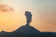 Barren Island erupts
 Crater on Barren Island in 2016.
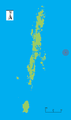 Outline map of the Andaman Islands, with the location of Barren Island highlighted (red circle)
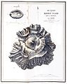 Topography of the island
 INS Saryu (P54), IN LCU 55 and IN LCU 58 approaching Barren Island.
 Barren Island seen from INS Saryu (P54) in 2021.


See also
References
- "Islandwise Area and Population - 2011 Census" (PDF). Government of Andaman. Archived from the original (PDF) on 2017-08-28. Retrieved 2016-09-22.
- Sailing Directions (Enroute), Pub. 173: India and the Bay of Bengal (PDF). Sailing Directions. United States National Geospatial-Intelligence Agency. 2017. p. 274.
- "A&N Islands - Pincodes". 2016-09-22. Archived from the original on 2014-03-23. Retrieved 2016-09-22.
{{cite web}}: CS1 maint: bot: original URL status unknown (link) - "STD Codes of Andaman and Nicobar". All Codes India. May 25, 2017.
- Registration Plate Numbers added to ISO Code
- Srivastava, Priya (2018-11-21). "All about Barren Island, South Asia's Only Active Volcano in Andaman". Times of India.
- Benjamin Elisha Sawe (15 March 2019). "Which Is The Only Active Volcano In South Asia?". Retrieved 2019-03-15.
- Dr. Aditi Jain. "Volcanic spewing in Barren Island is continuation of 2005 eruption". Retrieved 2018-02-09.
- Mishra, Rashmi. "List of Volcanoes in India: The only Indian live Volcano at Andaman & Nicobar Islands is Active again!". Retrieved 2017-02-18.
- Koshy, Jacob (26 February 2017). "Why did Barren Island volcano erupt again?". The Hindu. Retrieved 26 February 2017.
- "Barren Island". Global Volcanism Program. Smithsonian Institution.
- Aabech, Jørgen S. "Barren Island, Andaman Islands, Indian Ocean". Retrieved 2013-06-01.
- Mallet, F.R. (1895). "Bibliography of Barren Island and Narcondam, from 1884 to 1894". Records of the Geological Survey of India. 28: 34–38.
- "Directorate General of Lighthouses and Lightships". dgllnoida.gov.in. Archived from the original on 12 March 2013. Retrieved 14 January 2022.
- "NIO finds Andaman volcano spewing lava - Times of India". The Times of India. Retrieved 18 February 2017.
- "India's only live volcano active again: National Institute of Oceanography". The Indian Express. 18 February 2017. Retrieved 18 February 2017.
- "Barren Island volcano, India's only live volcano, became active in January". hindustantimes.com/. 18 February 2017. Retrieved 18 February 2017.
- Ray et al., Bull Volcanol 77: 57, 2015
- "Barren Island Volcano, Indian Ocean - facts & information". Volcanodiscovery.com. Retrieved 2013-06-01.
- G. S. Mudur (3 August 2003). "Mystery that got science's goat - Barren Island puzzle solved: springs, not special kidneys, sustain animals". The Telegraph (Kolkata). Retrieved 21 September 2019.
- "Scientific Expedition to Barren Island (Andaman Islands, Indian Ocean)". 2003. Archived from the original on 2 April 2012. Retrieved 2013-06-01.
- Krestovnikoff, Miranda; Halls, Monty (17 July 2006). Scuba Diving. DK Publishing. pp. 275–. ISBN 978-0-7566-4063-7.
- Pinto, Stanley (15 November 2013). "Scuba dive at an active volcano on Barren Island in Andamans". The Times of India. TNN. Retrieved 24 October 2021.
- "Village Code Directory: Andaman & Nicobar Islands" (PDF). Census of India. Retrieved January 16, 2011.
- "Volcano news & eruption updates: Barren Island". Retrieved 2019-10-17.
External links
- Geological Survey of India : THE BARREN ISLAND VOLCANO
- Department of Earth Sciences, IIT Bombay
- Bhaumik, Subir (11 July 2005). "Andamans volcano is post-tsunami hit". BBC News. Retrieved 2013-06-01.
- Geological Survey of India
Authority control | |
|---|---|
| General | |
| National libraries | |
На других языках
[de] Barren Island (Andamanen)
Barren Island ist eine kleine Vulkaninsel im Indischen Ozean, die zum Archipel der Andamanen gehört und etwa 100 km östlich der Hauptinseln liegt. Sie hat einen Durchmesser von etwa 4 km, eine Fläche von rund 8 km² und erreicht eine Höhe von 354 m über dem Meer. Barren Island ist unbewohnt und gehört politisch zum indischen Unionsterritorium Andamanen und Nikobaren.- [en] Barren Island (Andaman Islands)
[fr] Île Barren
L'île Barren (l'« île stérile ») est une petite île volcanique inhabitée de l'océan Indien, localisée dans la mer d'Andaman, à 99 kilomètres à l’est-sud-est d'Andaman centrale (Middle Andaman), une île majeure des îles Andaman. Elle appartient administrativement au territoire des îles Andaman-et-Nicobar, inclus dans la république de l'Inde.[it] Isola Barren
L'isola Barren è un'isola dell'arcipelago delle Andamane. Fa parte del territorio indiano delle Andamane e Nicobare.[1][ru] Баррен (Андаманские острова)
Баррен (англ. Barren Island) — активный вулкан на одноимённом острове, принадлежит Индии.Другой контент может иметь иную лицензию. Перед использованием материалов сайта WikiSort.org внимательно изучите правила лицензирования конкретных элементов наполнения сайта.
WikiSort.org - проект по пересортировке и дополнению контента Википедии