geo.wikisort.org - Island
Astola Island (Urdu: جزِیرہ اَستُولا) also known as Jezira Haft Talar (Balochi and Urdu: زروان ءِ هفت تلار) Satadip or 'Island of the Seven Hills', is a small uninhabited Pakistani island in the Arabian Sea approximately 25 km (16 mi) south of the nearest part of the coast and 39 km (24 mi) southeast of the fishing port of Pasni. Astola is Pakistan's largest offshore island at approximately 6.7 km (4.2 mi) long with a maximum width of 2.3 km (1.4 mi) and an area of approximately 6.7 km2 (2.6 sq mi). The highest point is 246 ft (75 m) above sea level. Administratively, the island is part of the Pasni subdistrict of Gwadar District in Balochistan province. The island can be accessed by motorized boats from Pasni, with a journey time of about 5 hours to reach the island. On August 4, 2020, Pakistan has released a new political map[5] that for the first time shows the Islands of Churna and Astola.[6]
This article needs additional citations for verification. (March 2013) |
 A view of the northern face of Astola Island, the skeletal lighthouse is in the upper left | |
 | |
| Location | Astola Island, Balochistan, Gwadar District, Pakistan |
|---|---|
| Coordinates | 25°07′08″N 63°50′00″E |
| Tower | |
| Constructed | 1982 |
| Construction | concrete (foundation), metal (tower) |
| Height | 10 m (33 ft) |
| Shape | square pyramidal skeletal tower[1][2][3] |
| Markings | grey |
| Power source | solar power |
| Light | |
| Focal height | 89 m (292 ft) |
| Lens | Type LASE-28/6 |
| Intensity | 25,500 candela |
| Range | 19 nmi (35 km; 22 mi) |
| Characteristic | Fl W 15s |
Ramsar Wetland | |
| Designated | 10 May 2001 |
| Reference no. | 1063[4] |
Marine Protected Area
Pakistan declared Astola as its first Marine Protected Area in June 2017 as part an international obligation of the Federal Government under the Convention on Biological Diversity and its Aichi Biodiversity Targets.[7]
History
The earliest mention of Astola is in Arrian's account of Admiral Nearchos, who was dispatched by Alexander the Great to explore the coast of the Arabian Sea and the Persian Gulf in 325 BC. The sailors in Nearchos's fleet were "frightened at the weird tales told about an uninhabited island, which Arrian calls Nosala".[8] It was also called Carmina, Karmine, by Arrian.[9]
Geography
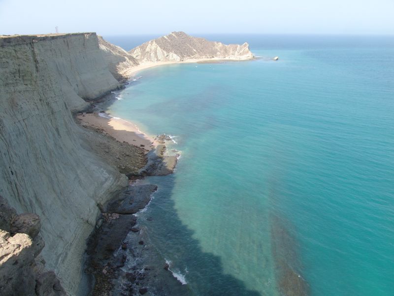
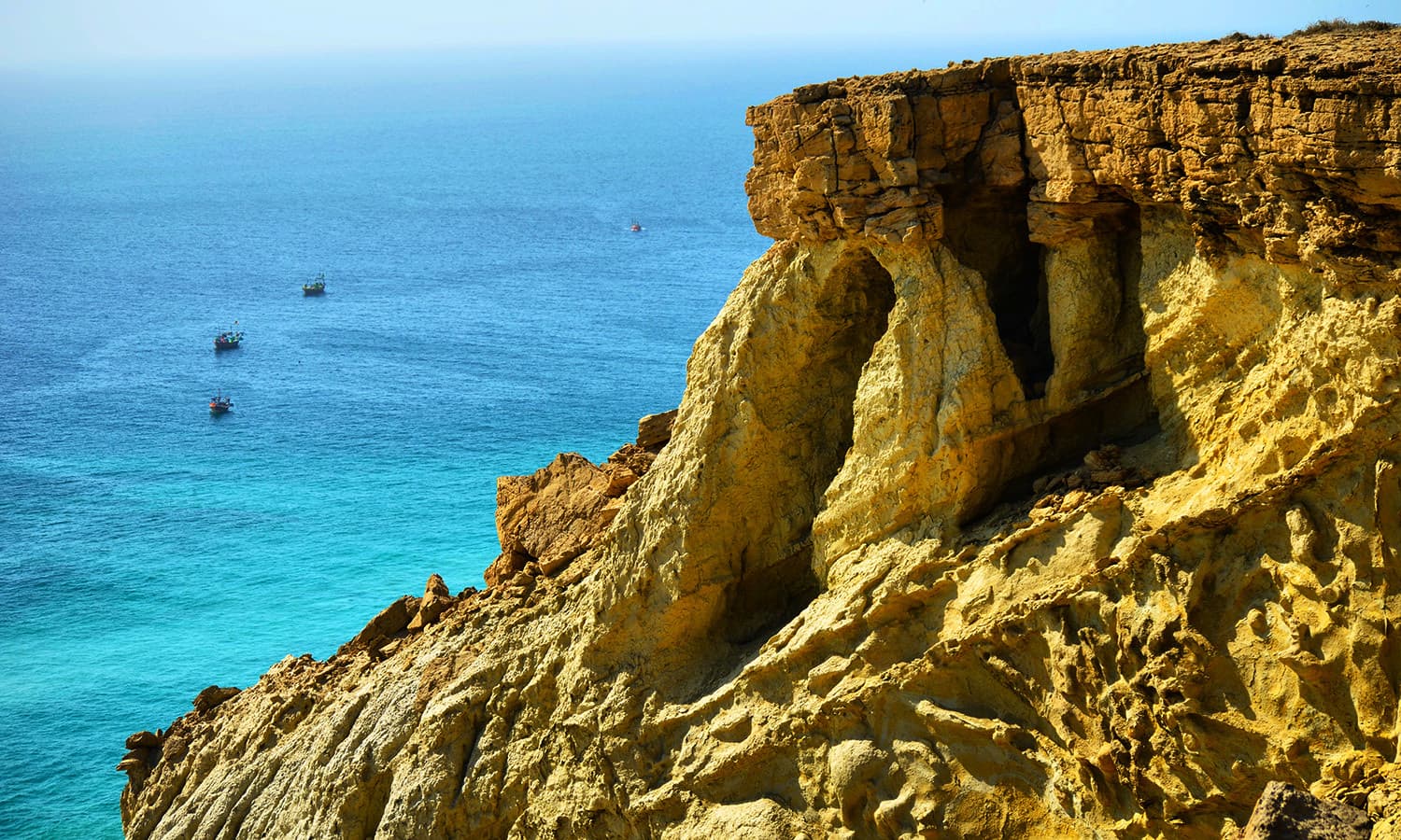
The island consists of a large tilted plateau and a series of seven small hillocks (hence the local name "Haft Talar" or "Seven Hills"), with deep chasms and crevices, which are several feet wide.[citation needed] There are several natural caves and coves on the island. The south face of the island slopes off gradually whereas the north face is cliff-like with a sharp vertical drop.[citation needed]
Ecology
Isolation has helped maintain several endemic life forms on Astola. The endangered green turtle (Chelonia mydas) and the hawksbill turtle (Eretmochelys imbracata) nest on the beach at the foot of the cliffs. The island is also an important area for endemic reptiles such as the Astola viper (Echis carinatus astolae). The island is reported to support a large number of breeding water birds including coursers, curlews, godwit, gulls, plovers and sanderling. Feral cats originally introduced by fishermen to control the endemic rodent population, pose an increasing threat to wildlife breeding sites. E.g. the sooty gull (Larus hemprichii) had a major breeding colony on the island, now extirpated because of introduced rats.[10]
Vegetation on the island is sparse and largely consists of scrubs and large bushes. There are no trees on the island. The largest shrub on the island is Prosopis juliflora, which was introduced into South Asia in 1877 from South America. There is no source of fresh water on the island and the vegetation depends on occasional rainfall and soil moisture for survival. Astola is also home to coral reef.
Man-made features
In 1982, the Government of Pakistan installed a lighthouse on the island for the safety of passing vessels, which was replaced by a solar-powered one in 1987.[11]
Between September and May of each year, Astola becomes a temporary base for mainland fishermen for catching lobsters and oysters. From June to August, the island remains uninhabited due to the fishing off-season, the rough seas and high tides.
There is a small mosque dedicated to the Muslim saint Pir Khawaja Khizr, which is used by the mainland fishermen during the fishing season. Ruins of an ancient Hindu temple of the Hindu goddess, Kali are located on the island.[12] The island was also known to the Hindus as Satadip.[13]
In Arrian's Indica, which describes the westward journey of Alexander's fleet after the Indian Campaign (325 BC), Admiral Nearchus is quoted as having anchored by an island named 'Carnine'. It was said to be inhabited by the Ichthyophagoi ('fish eaters' in Greek) and where, "even mutton had a fishy taste". The Persian phrase mahi khoran (fish eaters) has become the modern name of the coastal region of Makran. Some scholars have assumed Carnine to be Astola, without considering the extreme aridity and lack of fresh water, which renders the place inhospitable for human habitation, as well as animal husbandry. In all likelihood, Carnine was the name of an island in the inland sea, presently known as Khor Kalmat. This latter conjecture supports Nearchus' coast-hugging voyage (which would have kept him well away from Astola), a compulsion meant to provision Alexander's army that was supposed to have marched along a coastal route.
Gallery


See also
- List of lighthouses in Pakistan
- List of islands of Pakistan
References
- Rowlett, Russ. "Lighthouses of Pakistan". The Lighthouse Directory. University of North Carolina at Chapel Hill. Retrieved 2016-10-13.
- NGA List of Lights – Pub.112, Msi.nga.mil, Retrieved 13 October 2016
- Mercantile Marine Department, Mercantilemarine.gov.pk, Retrieved 13 October 2016
- "Astola Island". Ramsar Sites Information Service. Retrieved 25 April 2018.
- [permanent dead link]
- Siddiqui, Dawn. "In landmark move, PM Imran unveils 'new political map' of Pakistan". Dawn.com. Retrieved 2021-09-06.
- "'Corals in Astola Island bristle with marine life'". Dawn.com. 2020-12-20. Retrieved 2020-12-20.
- Jackson, A.V. Williams (1906). History of India, Volume II. London: The Grolier Society. p. 96.
- Arrian, Indica (book 8), chap. 26
- Grimmett, Richard, Roberts, Tom and Inskipp, Tim, 2008. Birds of Pakistan. Helm Field Guides, London, p. 112
- "Astola Island". Mercantilemarine.gov.pk. Retrieved 29 January 2022.
- Information Sheet on Ramsar Wetlands, Ramsar Convention on Wetlands. "Pakistan, Astola (Haft Talar) Island, 2001". Archived from the original on 2006-01-17. Retrieved 2006-04-22.
- S.A.J. Shirazi, ContactPakistan.com. "Astola with Sherazi". Archived from the original on 19 May 2006. Retrieved 2006-04-22.
External links
- Astola Island – A Spellbinding Site Archived 2014-01-18 at the Wayback Machine
- Astola Island
- Astola Island...
| National parks |
|
|---|---|
| Wildlife sanctuaries |
|
| Game reserves |
|
| Protected wetlands |
|
| Natural monuments |
|
| Protected forests |
|
| Biosphere reserves |
|
На других языках
[de] Astola (Insel)
Astola, auch Jezira Haft Talar (Belutschi: زروان ءِ هفت تلار, Satadip oder Insel der sieben Hügel), ist eine kleine, unbewohnte pakistanische Insel im Arabischen Meer rund 25 Kilometer südlich der belutschischen Südküste und 39 Kilometer südöstlich der Stadt Pasni. Astola ist die größte Insel Pakistans. Sie ist 6,7 km lang, bis zu 2,3 km breit, und weist eine Fläche von 6,7 km² auf. Sie erreicht eine Höhe von 75 Metern.- [en] Astola Island
[es] Isla Astola
La Isla Astola (también conocida como Jezira Haft Talar, en urdú: جزیرہ ہفت تلار o ‘siete colinas’ en baluchi: زروان ءِ هفت تلار) se halla situada en el mar Arábigo, a una distancia aproximada de 25 km de la costa de Baluchistán pakistaní y a unos cuarenta kilómetros al sudeste del puerto de Pasni, su punto más elevado tiene 246 pies y el área total es de aproximadamente 4 km². La isla tiene aproximadamente cuatro kilómetros de longitud y un kilómetro de ancho, en forma de meseta inclinada, con una serie de colinas y profundas grietas de varios pies de anchura. La parte sur de la isla asciende gradualmente hacia el norte, donde finaliza con un acantilado. Hay varias cavernas naturales por toda la isla.[ru] Астола (остров)
Остров Астола, также известный как «Джезира Хафт Талар» (урду جزیرہ ہفت تلار) или «Остров семи холмов» — маленький необитаемый остров в Пакистане, в Аравийском море, примерно в 25 км к югу от ближайшего побережья и 39 км на юго-восток от рыболовецкого города-порта Пасни. Остров принадлежит округу Гвадар города Пасни провинции Белуджистан. Добраться до острова можно на моторной лодке из порта Пасни, приблизительно за 5 часов.Другой контент может иметь иную лицензию. Перед использованием материалов сайта WikiSort.org внимательно изучите правила лицензирования конкретных элементов наполнения сайта.
WikiSort.org - проект по пересортировке и дополнению контента Википедии