geo.wikisort.org - Island
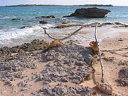
Anguillita is a small, uninhabited rocky island off the western tip of, and part of the territory of Anguilla,[3] located in the Caribbean. It's the dependency's southernmost point, located at coordinates 18°9' N, 63°11' W. Its average elevation is inverted compared to most, at -89 feet below sea level.[3]
 | |
 Anguillita The location of Anguillita within Anguilla  Anguillita Anguillita (Caribbean) | |
| Geography | |
|---|---|
| Location | Atlantic Ocean |
| Coordinates | 18°09′29.3″N 63°10′32.6″W |
| Archipelago | Antilles |
| Administration | |
United Kingdom | |
| British Overseas Territory | Anguilla |
| Additional information | |
| Time zone |
|
| ISO code | AI |
| Anguillita Lighthouse | |
| Foundation | concrete base |
| Construction | aluminium skeletal tower[1][2] |
| Height | 8 m (26 ft) |
| Shape | square prism skeletal tower with beacon |
| Power source | solar power |
| Focal height | 15 m (49 ft) |
| Range | 5 nmi (9.3 km; 5.8 mi) |
| Characteristic | Fl(2) W 16s |
Characteristics
Unlike Scrub Island, a larger island off the Eastern Tip and which has two excellent beaches, Anguillita is rarely even seen, since the western tip is virtually inaccessible by foot. As such it is rarely visited by tourists, though it is accessible by sea kayak.
Anguillita offers opportunities for scuba divers, and good snorkelling conditions can be found off its rugged coast. Species such as barracudas, stingrays, and turtles can be seen in its waters. There are three ledged mini-walls at a depth of some 5–20 metres, and numerous small underwater caves.
See also
- List of lighthouses in Anguilla
References
- Rowlett, Russ. "Lighthouses of Anguilla". The Lighthouse Directory. University of North Carolina at Chapel Hill. Retrieved 27 August 2016.
- List of Lights, Pub. 110: Greenland, The East Coasts of North and South America (Excluding Continental U.S.A. Except the East Coast of Florida) and the West Indies (PDF). List of Lights. United States National Geospatial-Intelligence Agency. 2016.
- "Anguillita Island." Archived 2012-04-23 at the Wayback Machine Chinci World Atlas Archived 2013-10-12 at the Wayback Machine. Accessed October 2011.
На других языках
[de] Anguillita
Anguillita ist eine kleine, felsige Insel im Karibischen Meer vor der Südwestspitze der Insel Anguilla und gehört wie diese zum gleichnamigen britischen Überseegebiet Anguilla. Die unbewohnte Insel misst etwa 300 mal 100 Meter und ist von Anguilla durch einen knapp 400 Meter breiten Meeresarm getrennt. In der Mitte der Insel verläuft ein schmaler Kanal, so dass Anguillita zumindest bei Flut aus zwei Inselchen und einigen Felsen besteht.- [en] Anguillita
[es] Anguillita
Anguillita es una pequeña isla rocosa en la punta occidental del territorio británico de ultramar de Anguila. Anguillita no es el punto más occidental de Anguila, esa posición se la queda una ubicada aún más al oeste los Cayos Prickly Pear. Sin embargo, es la dependencia más meridional. Está ubicado en las coordenadas 18°9'N, 63°11'W.[fr] Anguillita
Anguillita (-ita est un suffixe espagnol signifiant « petite ») est une petite île rocheuse du territoire britannique d'outre-mer d'Anguilla qui est située à l'Ouest de l'île principale. L'île mesure environ 300 m de long.[it] Anguillita
Anguillita è una piccola isola rocciosa situata poco distante dalla punta occidentale dell'isola di Anguilla.Другой контент может иметь иную лицензию. Перед использованием материалов сайта WikiSort.org внимательно изучите правила лицензирования конкретных элементов наполнения сайта.
WikiSort.org - проект по пересортировке и дополнению контента Википедии