geo.wikisort.org - Island
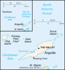
Scrub Island is an 8 km2 (3.1 sq mi) island lying off the eastern tip of the main island of Anguilla, a British Overseas Territory in the Caribbean. It is easily reached by boat. Privately owned,[1] the remains of an abandoned air field still exist. There are several abandoned houses on the island, mainly due to damage from hurricanes. There is no electricity or plumbing.
 View of Scrub Bay | |
 Scrub Island The location of Scrub Island within Anguilla  Scrub Island Scrub Island (Caribbean) | |
| Geography | |
|---|---|
| Location | Atlantic Ocean |
| Coordinates | 18°17′15″N 62°56′50″W |
| Archipelago | Antilles |
| Area | 8 km2 (3.1 sq mi) |
| Administration | |
United Kingdom | |
| British Overseas Territory | |
| Additional information | |
| Time zone |
|
| ISO code | AI |
Fauna
The island has been identified as an Important Bird Area by BirdLife International, mainly because of its nesting seabirds. These are laughing gulls as well as royal, roseate and least terns. Resident landbirds include Caribbean elaenias and pearly-eyed thrashers. The island's five species of reptiles comprise the Anguilla Bank ameiva, Anolis gingivinus, little dwarf gecko, island dwarf gecko and the endangered leeward island racer. Green and leatherback turtles have been recorded. Feral goats and rats are present.[2] Whales are commonly seen west of Scrub, along the southern coastline.
References
- "MOU signed for Scrub Island development". The Anguillan. 11 November 2011. Retrieved 9 January 2019.
- "Scrub Island". BirdLife data zone: Important Bird Areas. BirdLife International. 2012. Retrieved 2012-11-23.
External links
This Anguilla location article is a stub. You can help Wikipedia by expanding it. |
На других языках
[de] Scrub Island (Anguilla)
Scrub Island ist eine Insel in der Karibik und Teil des britischen Überseegebietes Anguilla. Die Insel ist mit einer Fläche von 3,48 km² die größte Nebeninsel Anguillas und liegt vor der nordöstlichen Spitze der Hauptinsel. Der Meeresarm zwischen beiden Inseln, der Scrub Island Channel, ist etwa 600 m breit.- [en] Scrub Island, Anguilla
[es] Scrub
La isla Scrub (en español antiguamente Isla Anguilita[1]) es la segunda isla en tamaño del archipiélago de Anguila, en el mar Caribe, localizada al noroeste de la isla de Anguila. Posee un área de 3,48 km² y se encuentra deshabitada. La forma más fácil de acceder a ella es por vía marítima, básicamente alquilando un bote o barco. Es posible observar ballenas en el oeste de la isla. Gran parte de su territorio es propiedad privada de la familia Hodge de Anguila.[cita requerida][fr] Île Scrub
L'île Scrub est une île inhabitée du territoire britannique d'outre-mer d'Anguilla. Deuxième de l'archipel par sa taille, elle est située à l'est de l'île d'Anguilla dont elle séparée par un canal sur 600 mètres. Elle mesure environ 4 km de long et sa surface est d'environ 8 km ².[it] Scrub Island (Anguilla)
Scrub Island è un'isola disabitata situata vicino alla punta orientale di Anguilla (sono separate da un canale largo circa 600 metri), la sua superficie è di 3,48 km².[ru] Скраб (остров)
Скраб (англ. Scrub) — остров, расположенный у восточной оконечности острова Ангилья, заморской территории Великобритании в Карибском море.Другой контент может иметь иную лицензию. Перед использованием материалов сайта WikiSort.org внимательно изучите правила лицензирования конкретных элементов наполнения сайта.
WikiSort.org - проект по пересортировке и дополнению контента Википедии