geo.wikisort.org - Island
Île Altazin is one of the Kerguelen Islands near the coast of Grande Terre, the principal island.
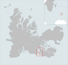 The Île Altazin is highlighted on this Kerguelen Islands map. | |
| Geography | |
|---|---|
| Location | Indian Ocean |
| Coordinates | 49°38′S 69°45′E |
| Archipelago | Îles Kerguelen |
| Highest elevation | 292 m (958 ft) |
| Highest point | unnamed hill |
| Administration | |
| District | Îles Kerguelen |
| Demographics | |
| Population | 0 |
It lies in the Swains Bay between the south-eastern part of the Gallieni Peninsula and the west coast of the Joan of Arc Peninsula, around 1 km NW of the Gaby Island.
The highest point of the island is an unnamed hill that reaches the elevation of 292 m above the sea level.
References
- Kerguelen islands map, Géoportail IGN.
- General view of non-metropolitan France, Maison de la Géographie.
This French Southern Territories location article is a stub. You can help Wikipedia by expanding it. |
На других языках
- [en] Île Altazin
[fr] Île Altazin
L'île Altazin est une île française de l'archipel des Kerguelen située dans la baie des Swains entre le sud-est de la péninsule Gallieni et l'ouest de la presqu'île Jeanne d'Arc.Текст в блоке "Читать" взят с сайта "Википедия" и доступен по лицензии Creative Commons Attribution-ShareAlike; в отдельных случаях могут действовать дополнительные условия.
Другой контент может иметь иную лицензию. Перед использованием материалов сайта WikiSort.org внимательно изучите правила лицензирования конкретных элементов наполнения сайта.
Другой контент может иметь иную лицензию. Перед использованием материалов сайта WikiSort.org внимательно изучите правила лицензирования конкретных элементов наполнения сайта.
2019-2025
WikiSort.org - проект по пересортировке и дополнению контента Википедии
WikiSort.org - проект по пересортировке и дополнению контента Википедии