geo.wikisort.org - Insel
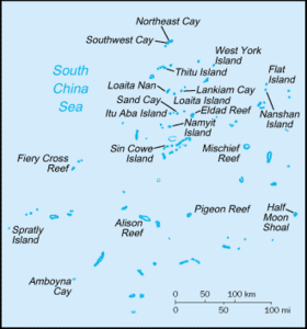
Die Spratly-Insel (vietnamesisch Đảo Trường Sa, englisch Spratly Island) ist eine Insel im Südchinesischen Meer im Pazifik. Sie zählt zu den Spratly-Inseln. Sie ist mit einer Fläche von 15 ha die viertgrößte der Inselgruppe, aber namensgebend. Auf ihr sind Soldaten aus Vietnam stationiert.[1] Es gibt einen kleinen Flugplatz mit einer ca. 900 m langen Landebahn und einen Schutzhafen.
| Spratly-Insel | |
|---|---|
| Gewässer | Südchinesisches Meer |
| Geographische Lage | 8° 38′ 43″ N, 111° 55′ 11″ O |
 | |
| Fläche | 15 ha |

Weblinks
Commons: Spratly Islands – Sammlung von Bildern, Videos und Audiodateien
Einzelnachweise
На других языках
- [de] Spratly-Insel
[en] Spratly Island
Spratly Island, also known as Storm Island (Vietnamese: Đảo Trường Sa Lớn; simplified Chinese: 南威岛; traditional Chinese: 南威島; pinyin: Nánwēi Dǎo; Tagalog: Pulo ng Lagos, lit. 'Lagos Island'), is the fourth largest of the naturally occurring[1] Spratly Islands in the South China Sea with an area of 15 hectares (37 acres),[2] and the largest of the Vietnamese-administered Spratly islands.[3][es] Isla Spratly
La Isla Spratly (propiamente dicha) o la isla de Truong Sa (tagalo: Lagos; chino: 岛 南威, pinyin: Dao Nanwei; vietnamita: Đảo Truong Sa) es una isla en las Islas Spratly en el Mar de China Meridional. Con una superficie de 15 hectáreas (0,15 km²), es la cuarta isla más grande del archipiélago de las Spratly y las más grande entre las islas Spratly ocupadas por los vietnamitas. Está cubierta con arbustos y césped. Es el hogar de algunas aves y tiene depósitos de guano. Un obelisco de 5,5 m de altura está ubicado en el extremo sur. La isla tiene una pista de aterrizaje de 610 metros (667 yardas) y un pequeño puerto pesquero. Situada a lo largo del arrecife está por encima del agua durante la marea baja.[2][fr] Île Spratley
L'Île Spratley, en vietnamien : Dảo Trường Sa, est une île située dans les îles Spratleys en mer de Chine méridionale. Elle est contrôlée par le Viêt Nam depuis 1975, mais est revendiquée par la Chine et Taïwan. L'île a été baptisé île de la Tempête en 1930, avant d'être renommée Nishitori jima par les japonais durant la Seconde Guerre mondiale. Elle est par la suite renommée île Nanwei par la Chine, avant d'être occupée par le Viêt Nam. L'île possède une piste d'atterrissage.Текст в блоке "Читать" взят с сайта "Википедия" и доступен по лицензии Creative Commons Attribution-ShareAlike; в отдельных случаях могут действовать дополнительные условия.
Другой контент может иметь иную лицензию. Перед использованием материалов сайта WikiSort.org внимательно изучите правила лицензирования конкретных элементов наполнения сайта.
Другой контент может иметь иную лицензию. Перед использованием материалов сайта WikiSort.org внимательно изучите правила лицензирования конкретных элементов наполнения сайта.
2019-2026
WikiSort.org - проект по пересортировке и дополнению контента Википедии
WikiSort.org - проект по пересортировке и дополнению контента Википедии