geo.wikisort.org - Insel
Pulau Pura ist eine Insel im Alor-Archipel in Indonesien.
| Pulau Pura | ||
|---|---|---|
 | ||
| Gewässer | Floressee, Sawusee | |
| Inselgruppe | Alor-Archipel | |
| Geographische Lage | 8° 17′ 54″ S, 124° 20′ 46″ O | |
| ||
| Länge | 6,7 km | |
| Breite | 6 km | |
| Fläche | 27,53 km² | |
| Höchste Erhebung | Pura 1015 m | |
| Einwohner | 1945 (2010) 71 Einw./km² | |
| Hauptort | Pura | |
Geographie
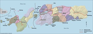
Die Insel liegt in der Pantarstraße zwischen den Inseln Alor und Pantar.[1] Pura hat eine Fläche von 27,53 km²[2] und erreicht eine Höhe von 1015 Metern. Sie bildet einen Distrikt in Kabupaten Alor.[3]
Übersicht der Dörfer:
| Desa/Kelurahan | Einwohnerzahl |
|---|---|
| Pura Barat | 156 |
| Pura Selatan | 166 |
| Maru | 111 |
| Pura Timur | 120 |
| Pura | 1.196 |
| Pura Utara | 196 |
Einzelnachweise

Verwaltungsgliederung des Regierungsbezirks Alor
Kabola | Lembur | Mataru | Nordzentralalor (Alor Tengah Utara) | Ostalor (Alor Timur) | Ostalor Meer (Alor Timur Laut) | Ostpantar (Pantar Timur) | Pantar | Insel Pura (Pulau Pura) | Pureman | Südalor (Alor Selatan) | Südwestalor (Alor Barat Daya) | Teluk Mutiara | Westalor Meer (Alor Barat Laut) | Westpantar (Pantar Barat) | Westpantar Meer (Pantar Barat Laut) | Zentralpantar (Pantar Tengah)
Текст в блоке "Читать" взят с сайта "Википедия" и доступен по лицензии Creative Commons Attribution-ShareAlike; в отдельных случаях могут действовать дополнительные условия.
Другой контент может иметь иную лицензию. Перед использованием материалов сайта WikiSort.org внимательно изучите правила лицензирования конкретных элементов наполнения сайта.
Другой контент может иметь иную лицензию. Перед использованием материалов сайта WikiSort.org внимательно изучите правила лицензирования конкретных элементов наполнения сайта.
2019-2026
WikiSort.org - проект по пересортировке и дополнению контента Википедии
WikiSort.org - проект по пересортировке и дополнению контента Википедии