geo.wikisort.org - Insel
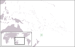
Nugent Island ist die nördlichste Insel der Kermadecinseln und damit das nördlichste Gebiet in Neuseeland. Es liegt nordöstlich von Neuseeland, ist ungefähr kreisförmig und hat einen Durchmesser von etwa 100 Metern. Nugent Island gehört zur Gruppe der Inseln rund um Raoul Island.
| Nugent Island | |
|---|---|
 | |
| Gewässer | Pazifischer Ozean |
| Inselgruppe | Kermadecinseln |
| Geographische Lage | 29° 13′ 54″ S, 177° 52′ 9″ W |
 | |
| Länge | 100 m |
| Breite | 100 m |
 | |
Das Gestein der Insel ist ungefähr 600.000 bis 1,4 Millionen Jahre alt; es besteht aus gehobener und gekippter Kissenlava und entstand bei submarinen Vulkanausbrüchen.[1]
Einzelnachweise
- Tim J. Worthington, Murray R. Gregory, Vladislav Bondarenko: The Denham Caldera on Raoul Volcano: dacitic volcanism in the Tonga–Kermadec arc. In: Journal of Volcanology and Geothermal Research. ISSN 0377-0273 90(1999), S. 29–48, hier S. 31f.
На других языках
- [de] Nugent Island
[en] Nugent Island
Nugent Island is the most northerly island in the Kermadec Islands and the most northerly part of New Zealand, being some 20 metres further to the North than nearby Napier Island. Nugent Island has a small island on the NW side with a narrow passage between. It is one of a group of islands to the north-east of Raoul Island. It is roughly circular and approximately 100 metres (330 ft) across, with a highest point of 66 m.[1] The island has never been modified by introduced mammals, and so has retained its original bird populations.[2] It forms part of the Kermadec Islands Important Bird Area, identified as such by BirdLife International because it is an important site for nesting seabirds.[3]Текст в блоке "Читать" взят с сайта "Википедия" и доступен по лицензии Creative Commons Attribution-ShareAlike; в отдельных случаях могут действовать дополнительные условия.
Другой контент может иметь иную лицензию. Перед использованием материалов сайта WikiSort.org внимательно изучите правила лицензирования конкретных элементов наполнения сайта.
Другой контент может иметь иную лицензию. Перед использованием материалов сайта WikiSort.org внимательно изучите правила лицензирования конкретных элементов наполнения сайта.
2019-2026
WikiSort.org - проект по пересортировке и дополнению контента Википедии
WikiSort.org - проект по пересортировке и дополнению контента Википедии