geo.wikisort.org - Insel
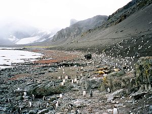
Die Livingston-Insel (englisch Livingston Island) ist die zweitgrößte Insel der Südlichen Shetlandinseln vor der Westantarktis.
| Livingston-Insel | ||
|---|---|---|
 | ||
| Gewässer | Südlicher Ozean (zwischen Drake- und Bransfieldstraße) | |
| Inselgruppe | Südliche Shetlandinseln | |
| Geographische Lage | 62° 36′ S, 60° 30′ W | |
|
| ||
| Länge | 73 km | |
| Breite | 35 km | |
| Fläche | 974 km² | |
| Höchste Erhebung | Mount Friesland 1700 m | |
 | ||
Die Insel ist 73 km lang und 34 km breit, die Fläche beträgt 974 km². Sie liegt westlich der benachbarten Greenwich Island sowie nördlich der Deception-Insel. Der höchste Punkt Livingstons ist mit 1700 Metern der Berggipfel Mount Friesland in den Tangra Mountains. Die Temperaturen im Sommer überschreiten kaum 3 °C, im Winter kann es bis −14 °C kalt werden.
Die Insel wurde am 19. Februar 1819 vom englischen Seefahrer William Smith entdeckt und bereits kurz darauf von Robbenjägern aufgesucht.
Heute befinden sich auf Livingston einige antarktische Forschungsstationen, darunter die spanische Juan-Carlos-I.-Station und die bulgarische St.-Kliment-Ohridski-Station. Die Insel ist auch Station für den Besuch von Kreuzfahrtschiffen.
Nach dem deutschen Politiker Manfred Wörner wurde der hier vorhandene Bergsattel Wörner Gap benannt.
Karten
- L. L. Ivanov: Antarctica: Livingston Island and Greenwich, Robert, Snow and Smith Islands. Topografische Karte im Maßstab 1:120.000. Manfred-Wörner-Stiftung, Troyan, 2009, ISBN 978-954-92032-6-4
- L. L. Ivanov. Antarctica: Livingston Island and Smith Island. Scale 1:100000 topographic map. Manfred Wörner Foundation, 2017. ISBN 978-619-90008-3-0
Weblinks
- Ivanov, L. General Geography and History of Livingston Island. In: Bulgarian Antarctic Research: A Synthesis. Eds. C. Pimpirev and N. Chipev. Sofia: St. Kliment Ohridski University Press, 2015. S. 17–28. ISBN 978-954-07-3939-7
- Ivanov, L.L. Livingston Island: Tangra Mountains, Komini Peak, west slope new rock route; Lyaskovets Peak, first ascent; Zograf Peak, first ascent; Vidin Heights, Melnik Peak, Melnik Ridge, first ascent. The American Alpine Journal, 2005. S. 312–315.
- Gildea, D. Mountaineering in Antarctica: complete guide: Travel guide. Primento and Editions Nevicata, 2015. ISBN 978-2-51103-136-0
На других языках
- [de] Livingston-Insel
[en] Livingston Island
Livingston Island (Russian name Smolensk,[1][2] 62°36′S 60°30′W) is an Antarctic island in the Southern Ocean, part of the South Shetlands Archipelago, a group of Antarctic islands north of the Antarctic Peninsula. It was the first land discovered south of 60° south latitude in 1819, a historic event that marked the end of a centuries-long pursuit of the mythical Terra Australis Incognita and the beginning of the exploration and utilization of real Antarctica. The name Livingston, although of unknown derivation, has been well established in international usage since the early 1820s.[es] Isla Livingston
La isla Livingston es la segunda en superficie de las islas Shetland del Sur en la Antártida. Se ubica entre la isla Nevada o Snow al oeste (separada por el estrecho Morton) y la isla Greenwich por el este (separada por el estrecho Mac Farlane). Unos 20 km al sur de Livingston está la isla Decepción.[fr] Île Livingston
L'île Livingston (Smolensk) est la deuxième île par la taille de l'archipel des Shetland du Sud situé au nord de l’Antarctique. Sa longueur est de 73 km dans le sens est-ouest, et sa superficie de 974 km2. Le point Hannah sur le littoral sud et l’île Half Moon, près de la côte est, sont des destinations parmi les plus populaires du tourisme antarctique et austral extrême, souvent visitées par des bateaux d’excursion.[it] Isola Livingston
L'isola Livingston è la seconda più grande isola nelle Shetland Meridionali, in Antartide. L'isola si estende in senso est-ovest per 73 km, e ha un'area di 974 km²: essa è situata nell'oceano Antartico fra il canale di Drake e lo stretto di Bransfield, 110 km a nord-ovest della penisola Antartica e 830 km a sud-sud-est del capo Horn.[ru] Ливингстон (остров)
Ли́вингстон или Смоленск (англ. Livingston Island) — второй по площади остров архипелага Южные Шетландские острова.Другой контент может иметь иную лицензию. Перед использованием материалов сайта WikiSort.org внимательно изучите правила лицензирования конкретных элементов наполнения сайта.
WikiSort.org - проект по пересортировке и дополнению контента Википедии
