geo.wikisort.org - Insel
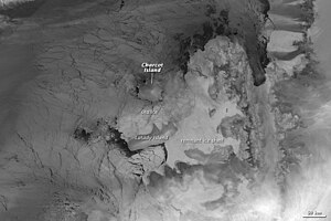
Die Latady-Insel (engl. Latady Island) ist eine von Eis bedeckte Insel in der Westantarktis. Sie liegt 72 km südlich der Charcot-Insel und westlich der Alexander-Insel und bildet die südöstliche Begrenzung des Wilkins-Schelfeises. Die Insel ist etwa 60 km lang, 40 km breit und hat eine Fläche von 3,300 km². 1929 sah Sir Hubert Wilkins aus der Luft ein eisbedecktes Gebilde an dieser Stelle und beschrieb diese, erkannte aber weder, dass es sich um eine Insel handelt, noch kartografierte er sie separat.
| Latady-Insel | ||
|---|---|---|
 | ||
| Gewässer | Bellingshausensee (Südlicher Ozean) | |
| Geographische Lage | 70° 55′ S, 75° 10′ W | |
|
| ||
| Länge | 115 km | |
| Breite | 48 km | |
| Fläche | 3 300 km² | |
| Einwohner | unbewohnt | |
Die Latady-Insel wurde aus der Luft während der Ronne Antarctic Research Expedition (RARE) in den Jahren 1947 und 1948 fotografiert und 1960 anhand dieser Fotos durch den britischen Geographen Derek Searle vom Falkland Islands Dependencies Survey (FIDS) kartografiert. Das UK Antarctic Place-Names Committee benannte die Insel 1961 nach William Robertson Latady (1918–1979), einem Luftfotografen und Navigator des Fluges der RARE.
Weblinks
- 'Webcam’ from Space Envisat Advanced Synthetic Aperture Radar (ASAR)
- Latady Island im Geographic Names Information System des United States Geological Survey (englisch). (englisch)
- Latady Island auf geographic.org (englisch)
На других языках
- [de] Latady-Insel
[en] Latady Island
Latady Island is a low ice-covered island off Antarctica, about 35 nmi (65 km) long and 10 nmi (20 km) wide, lying 45 nmi (85 km) south of Charcot Island and west of Alexander Island. An ice-covered feature in this approximate position was seen from the air and described by Sir Hubert Wilkins in 1929, but not recognized as an island or separately mapped. Latady Island was first photographed from the air by the Ronne Antarctic Research Expedition (RARE), 1947–1948, and mapped from these photos by D. Searle of the Falkland Islands Dependencies Survey in 1960. it was named by the UK Antarctic Place-Names Committee for William R. Latady, an aerial photographer and navigator on the RARE flight.[1][es] Isla Latady
La isla Latady es un isla de la Antártida cubierta por el hielo, de unas 35 millas de largo por unas 10 millas de ancho. Se ubica a unas 45 millas al sur de la isla Charcot y al oeste de la isla Alejandro I. Su área aproximada es de 3300 km².[it] Isola Latady
L'isola Latady è un'isola situata al largo dell'Antartico, nel mare di Bellingshausen, a circa 85 chilometri dalla costa meridionale dell'isola Charcot e a circa 45 km dalla costa settentrionale della penisola Beethoven, nella parte sud-occidentale dell'isola Alessandro I. Politicamente contesa tra Cile che la rivendica nel territorio antartico cileno e il Regno Unito che la annovera tra i suoi territori d'oltre mare antartici, l'isola, che è interamente coperta di ghiaccio, è completamente disabitata ed è larga circa 20 km e lunga circa 65.[1] Fino a pochi anni fa, la costa orientale dell'isola era unita a quella occidentale dell'isola Alessandro I dalla piattaforma glaciale Wilkins, che la univa anche all'isola Charcot, tuttavia, a seguito del riscaldamento globale che, a partire dagli anni 1950, ha fatto sì che le temperature in questa regione dell'Antartide salissero 2,5 gradi Celsius, la struttura che rimaneva connessa all'isola Latady si è via via disintegrata.[2][3]Другой контент может иметь иную лицензию. Перед использованием материалов сайта WikiSort.org внимательно изучите правила лицензирования конкретных элементов наполнения сайта.
WikiSort.org - проект по пересортировке и дополнению контента Википедии
