geo.wikisort.org - Insel
Faraulep, Faraulip oder Faraulap (auch als Gardner bezeichnet) ist ein Atoll im Osten des Bundesstaats Yap der Föderierten Staaten von Mikronesien und gehört damit zur Inselgruppe der Karolinen im Pazifischen Ozean.
| Faraulep | ||
|---|---|---|
 | ||
| Gewässer | Pazifischer Ozean | |
| Archipel | Karolinen | |
| Geographische Lage | 8° 36′ N, 144° 31′ O | |
| ||
| Anzahl der Inseln | 3 | |
| Hauptinsel | Nigaruyaru | |
| Länge | 4,1 km | |
| Breite | 3 km | |
| Landfläche | 42,2 ha | |
| Lagunenfläche | 2,336 km² | |
| Gesamtfläche | 7 km² | |
| Einwohner | 221 (2000) | |
 | ||

Geographie
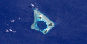
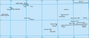
Faraulep liegt 116 km südwestlich der Insel Gaferut und 695 ostsüdöstlich der Hauptinsel von Yap. Das Atoll weist einen annähernd quadratischen Grundriss auf, mit Seitenlängen von 3 bis 4 km, und einer Gesamtfläche von 7 km²[1]. Der breite Riffranz umschließt eine kleine, tiefe Lagune, die nur im Südwesten eine Öffnung aufweist. Das Atoll weist drei Inseln auf, mit einer Gesamtfläche von gut 40 Hektar:[2]
- Fuasubukoru (8° 36′ 56″ N, 144° 32′ 2″ O), bewohnt, 10,2 ha
- Nigaruyaru (8° 36′ 23″ N, 144° 32′ 4″ O), bewohnt, 20,2 ha
- Eate (8° 35′ 14″ N, 144° 33′ 0″ O), unbewohnt, 11,7 ha
Die Bevölkerung betrug 221 zur Volkszählung 2000[3]. Sie verteilt sich auf die beiden Dörfer Nigaruyaru und Fuasubukoru auf den gleichnamigen Inseln.
Das Atoll wurde 1828 von dem russischen Weltumsegler Friedrich Benjamin von Lütke entdeckt.
Verwaltung
Faraulep bildet eine Gemeinde (municipality) des Staates Yap, zu der auch die Insel Gaferut gehört. Die Gemeinde gehört zum vierten Wahlbezirk des Bundesstaates Yap, einem der insgesamt fünf Wahlbezirke.[4][5]
Literatur
- Stichwort: Faraulip. Online in: Deutsches Kolonial-Lexikon, Band I, Leipzig 1920, S. 600.
Einzelnachweise
- Oceandots (Memento vom 23. Dezember 2010 im Internet Archive)
- Otis W. Freeman, Geography of the Pacific, Wiley 1953
- 2000 census of Yap (PDF; 2,9 MB)
- http://www.pacificworlds.com/yap/home/location.cfm
- Yap State Code, Title 7, Elections, §111 Election districts
На других языках
- [de] Faraulep
[en] Faraulep
Faraulep Atoll is a coral atoll of three islands in the central Caroline Islands in the Pacific Ocean, and forms a legislative district in Yap State in the Federated States of Micronesia. Its total land area is only 0.422 square kilometres (0.163 sq mi), but it encloses a deep central lagoon of 7 square kilometres (2.7 sq mi) with a single opening on the southwest side. Faraulep is located approximately 100 kilometres (62 mi) southwest of Gaferut, 150 kilometres (93 mi) northeast of Woleai, and 700 kilometres (430 mi) east of Yap.[fr] Faraulep
Faraulep est un atoll corallien constitué de trois îles situé dans les îles Carolines dans l'océan Pacifique. Il appartient aux îles extérieures de Yap. Il constitue une municipalité de l'État de Yap des États fédérés de Micronésie. L'île isolée et inhabitée de Gaferut à 116 km au nord-est lui est rattaché. Dans le cadre des élections législatives internes à l'État de Yap, la municipalité appartient avec celles d'Eauripik et d'Ifalik au quatrième district électoral. Ce district élit pour quatre ans un sénateur au scrutin uninominal majoritaire à un tour[1],[2]. La municipalité est peuplée de 193 habitants en 2010.[ru] Фараулеп
Фараулеп (англ. Faraulep) — атолл в Тихом океане в архипелаге Каролинские острова. Является частью Федеративных Штатов Микронезии и административно входит в состав штата Яп.Другой контент может иметь иную лицензию. Перед использованием материалов сайта WikiSort.org внимательно изучите правила лицензирования конкретных элементов наполнения сайта.
WikiSort.org - проект по пересортировке и дополнению контента Википедии