geo.wikisort.org - Insel
Die Brabant-Insel (französisch Île Brabant, englisch Brabant Island; spanisch Isla Brabante) ist die zweitgrößte Insel im Palmer-Archipel. Sie gehört zum britischen, argentinischen und chilenischen Antarktisterritorium. Die Insel liegt südlich der Bransfieldstraße zwischen der Anvers-Insel und Liège Island. Ihre Nord-Süd-Ausdehnung beträgt 53 km. Sie ist 25 km breit, hat eine Fläche von 976,8 km² und erreicht im Mount Parry eine Höhe von 2520 m[1][2] (nach anderer Quelle 2522 m[3]).
| Brabant Island | ||
|---|---|---|
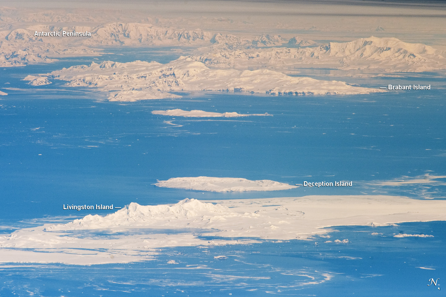 | ||
| Gewässer | Südlicher Ozean (Dallmann-Bucht, Schollaert-Kanal, Gerlache-Straße, Bouquet Bay) | |
| Inselgruppe | Palmer-Archipel | |
| Geographische Lage | 64° 15′ S, 62° 20′ W | |
| ||
| Länge | 53 km | |
| Breite | 25 km | |
| Fläche | 976,8 km² | |
| Höchste Erhebung | Mount Parry 2520 m | |
| Einwohner | unbewohnt | |

Die aufgrund ihrer Unzugänglichkeit noch wenig erforschte Insel ist ein Vulkanfeld, dessen Vulkane noch während des späten Pleistozäns (< 200 ka BP) aktiv waren.[4]
Die Brabant-Insel wurde von der Belgica-Expedition (1897–1899) unter Adrien de Gerlache de Gomery nach der damaligen belgischen Provinz Brabant benannt in Anerkennung der Unterstützung durch deren Bevölkerung.
Weblinks
- Brabant Island im Global Volcanism Program der Smithsonian Institution (englisch).
- Karte der Region.
Einzelnachweise
- John Stewart: Antarctica – An Encyclopedia. Bd. 2, McFarland & Co., Jefferson und London 2011, ISBN 978-0-7864-3590-6, S. 1182 (englisch).
- Mount Parry. In: Geographical Names. National Geospatial-Intelligence Agency, abgerufen am 27. Dezember 2017 (englisch).
- Islands of Antarctic Islands – Brabant. In: Island Directory. UNEP, abgerufen am 17. März 2017 (englisch).
- John L. Smellie et al.: Eruptive environment of volcanism on Brabant Island: Evidence for thin wet-based ice in northern Antarctic Peninsula during the Late Quaternary. In: Palaeogeography, Palaeoclimatology, Palaeoecology. Band 231, Nr. 1–2, 9. Februar 2006, S. 233–252, doi:10.1016/j.palaeo.2005.07.035 (englisch).
На других языках
- [de] Brabant-Insel
[en] Brabant Island
Brabant Island is the second largest island of the Palmer Archipelago within the British Antarctic Territory, lying between Anvers Island and Liège Island. Brabant Island is 59 km (37 mi) long north-south, 30 km (19 mi) wide, and rises to 2,520 m (8,268 ft) in Mount Parry. The interior of the island is occupied by two mountain ranges, Solvay Mountains (Cook Summit, 1590 m) in its southern part and Stribog Mountains (summit Mount Parry) in its central and northern parts.[es] Isla Brabante
La isla Brabante o Brabant es la segunda en extensión del archipiélago Palmer, adyacente a la costa nororiental de la península Antártica. Brabante se ubica entre la isla Lieja al noreste y la isla Anvers al suroeste, separadas por el canal Schollaert. El estrecho de Gerlache separa a Brabante de la Costa Danco, que forma parte de la península Antártica. Se localiza a 64°25′S 62°33′O.[fr] Île Brabant
L'île Brabant est une île située au large de la côte occidentale de la péninsule Antarctique.[it] Isola di Brabant
L'isola di Brabant è la seconda isola più grande dell'arcipelago Palmer all'interno del territorio antartico britannico, situata tra l'isola Anvers e l'isola Liège. L'isola di Brabant misura 59 km nella direzione nord-sud e 30 km nella direzione est-ovest, mentre la massima altitudine è raggiunta presso il monte Parry, la cui cima arriva a 2520 m s.l.m.. L'interno dell'isola è occupato da due catene montuose, le montagne di Solvay (la cui massima altezza, 1590 m s.l.m., è raggiunta presso il monte Cook), nella parte meridionale, e le montagne di Stribog (di cui fa parte il già citato monte Parry), nella parte centrale e settentrionale.[1][ru] Брабант (остров)
Брабант (англ. Brabant Island) — второй крупнейший остров в архипелаге Палмер.Другой контент может иметь иную лицензию. Перед использованием материалов сайта WikiSort.org внимательно изучите правила лицензирования конкретных элементов наполнения сайта.
WikiSort.org - проект по пересортировке и дополнению контента Википедии