geo.wikisort.org - Coast
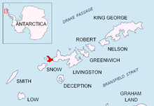
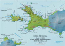
Varadero Point is a point projecting 620 m into Barclay Bay from Robbery Beaches on Byers Peninsula, Livingston Island in the South Shetland Islands, Antarctica and forming the west side of the entrance to Baba Tonka Cove. Dominated by Varadero Hill (116 m).


The point is named descriptively ('Boathouse Point') from being an area where icebergs get stranded.
Location
The point is located at 62°36′26.9″S 61°04′40.7″W which is 6.46 km southeast of Essex Point and 1.19 km west-northwest of Villard Point (British mapping in 1968, detailed Spanish mapping in 1992, and Bulgarian mapping in 2005 and 2009).
Maps
- Península Byers, Isla Livingston. Mapa topográfico a escala 1:25000. Madrid: Servicio Geográfico del Ejército, 1992.
- L.L. Ivanov et al. Antarctica: Livingston Island and Greenwich Island, South Shetland Islands. Scale 1:100000 topographic map. Sofia: Antarctic Place-names Commission of Bulgaria, 2005.
- L.L. Ivanov. Antarctica: Livingston Island and Greenwich, Robert, Snow and Smith Islands. Scale 1:120000 topographic map. Troyan: Manfred Wörner Foundation, 2009. ISBN 978-954-92032-6-4
References
На других языках
[de] Varadero Point
Der Varadero Point (englisch; spanisch Punta Varadero) ist eine Landspitze der Livingston-Insel im Archipel der Südlichen Shetlandinseln. Auf der Byers-Halbinsel bildet sie die Westseite der Baba Tonka Cove und wird vom 116 m hohen Cerro Varadero dominiert.- [en] Varadero Point
Текст в блоке "Читать" взят с сайта "Википедия" и доступен по лицензии Creative Commons Attribution-ShareAlike; в отдельных случаях могут действовать дополнительные условия.
Другой контент может иметь иную лицензию. Перед использованием материалов сайта WikiSort.org внимательно изучите правила лицензирования конкретных элементов наполнения сайта.
Другой контент может иметь иную лицензию. Перед использованием материалов сайта WikiSort.org внимательно изучите правила лицензирования конкретных элементов наполнения сайта.
2019-2025
WikiSort.org - проект по пересортировке и дополнению контента Википедии
WikiSort.org - проект по пересортировке и дополнению контента Википедии